- Maryland Route 30
-
Maryland Route 30
Hanover Pike 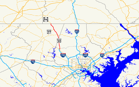
Route information Maintained by MDSHA Length: 19.16 mi[1][2] (30.84 km) Existed: 1933 – present Major junctions South end:  MD 140 in Reisterstown
 MD 128 in Reisterstown
 MD 91 near Fowblesburg
 MD 27 in Manchester
North end:  PA 94 at PA state line near Hanover
Location Counties: Baltimore, Carroll Highway system Maryland highway system
Interstate • US • State • Minor • Former • Turnpikes←  US 29
US 29MD 31  →
→Maryland Route 30 is a 19.16-mile (30.84 km) state highway in Central Maryland region in the U.S. state of Maryland. It serves as one of the major north–south routes of central Maryland.
Contents
Route description
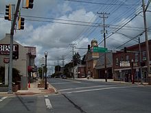 MD 30 northbound in Manchester
The route begins at a skewed intersection with MD 140 in northern Reisterstown. After intersecting with MD 128 the route runs north as a two-lane semi-rural country road. MD 30 intersects MD 91 in Fowblesburg before reaching Hampstead in Carroll County.
The Hampstead Bypass was recently opened for traffic on August 6, 2009, and now is the mainline routing for Maryland Route 30 in the town. The original alignment is now known as Maryland Route 30 Business and continues as Hampstead's Main Street. The need for the bypass was brought about due to the high levels of traffic and severe congestion that MD 30 experiences through Hampstead. The bypass skirts the west side of Hampstead, starting at a point on MD 30 slightly to the north of Wolf Hill Drive. The road is a total of 6.0 miles (9.7 km) long, and will not only have full access controls, but will also contain two grade separations - one at Houcksville Road and one at Shiloh Road. The bypass ends north of Hampstead, near Brodbeck Road, and includes three at-grade roundabouts—one at the southern terminus, with a spur to Wolf Hill Drive; one at MD 482; and one at the northern terminus just to the south of Brodbeck Road. Original rights-of-way, such as Houcksville Road, were converted into frontage roads.
Beyond Hampstead, it resumes its Hanover Pike moniker and continues running northwest, meeting MD 27 in Manchester. North of Manchester, MD 30 intersects MD 86 and MD 496 before continuing to the Pennsylvania state line, where it becomes PA 94.
The route is dotted with many small communities, neighborhoods and houses; traffic levels are therefore rather elevated, given the otherwise rural nature of the route. Traffic levels in Hampstead and Manchester are high and MD 30 through these towns is often congested and even halted due to the high levels of traffic.
Junction list
County Location Mile[1][2] Destinations Notes Baltimore Reisterstown 0.00 MD 140 (Westminster Road) – Westminster, Baltimore0.39 MD 128 (Butler Road) – Butlerroad west of intersection designated as MD 795; signed as MD 128 0.49 Old Hanover Road north former alignment of MD 30 1.16 Old Hanover Rd. south 2.51-2.53 Glen Falls Rd. west/Old Hanover Rd. east Fowblesburg 5.20 MD 91 south (Emory Road) to MD 140 – FinksburgEmory Rd. continues to Old Hanover Rd. 5.30 Old Hanover Rd. south former alignment of MD 30 6.28 Bortner Rd. west/Dover Rd. east - to Trenton Rd. Carroll 7.87 
 MD 30 Bus. north (Hanover Pike)
Roundabout, southern terminus of Hampstead Bypass Hampstead 10.49  MD 482 (Hampstead-Mexico Road) – Mexico
Roundabout 12.30
MD 30 Bus. south (Hanover Pike)Roundabout, northern terminus of Hampstead Bypass 13.19 Cape Horn Rd. south - to Harvey Gummel Rd. Manchester 14.49 York St. north - to Water Tank Rd. portion of York St. once part of both MD 27 and MD 31 MD 27 south (Westminster Road)former alignment of MD 27 14.72 MD 27 south (Manchester Road) – Westminster15.90  MD 86 north (Lineboro Road) – Lineboro to
  PA 516
16.25  MD 496 (Ebbvale Road) – Ebbvale
16.53 MD 86 (Traceys Mill Road)Melrose 17.35  MD 496 south (Bachman Valley Road) to MD 97 north (Wentz Road) – Bachman Mills
MD 496 runs south of MD 30 17.98 To MD 97 south (Deep Run Road) – Union Mills19.16 PA 94 north (Hanover Pike) – Hanovernorthern terminus of MD 30 1.000 mi = 1.609 km; 1.000 km = 0.621 mi MD 30 Business
Maryland Route 30 Business
Location: Hampstead Length: 4.00 mi[2] (6.44 km) Maryland Route 30 Business is a 4.00 miles (6.44 km) business route of MD 30 through Hampstead.[2] It was created on August 6, 2009 along the former alignment of MD 30 through the town after MD 30 was relocated onto the Hampstead Bypass.[3] The route is known as Main Street, a heavily congested arterial street, and intersects MD 88 and MD 482 in Hampstead.
References
- ^ a b Maryland State Highway Administration (2008). "Highway Location Reference: Baltimore County" (PDF). http://apps.roads.maryland.gov/KeepingCurrent/performTrafficStudies/dataAndStats/hwyLocationRef/2008_hlr_all/co03.pdf. Retrieved 2010-02-27.
- ^ a b c d Maryland State Highway Administration (2008). "Highway Location Reference: Carroll County" (PDF). http://apps.roads.maryland.gov/KeepingCurrent/performTrafficStudies/dataAndStats/hwyLocationRef/2008_hlr_all/co06.pdf. Retrieved 2010-02-27.
- ^ "STATE HIGHWAY ADMINISTRATION OPENS HAMPSTEAD BYPASS IN CARROLL COUNTY". Maryland State Highway Administration. 2009-08-06. http://apps.roads.maryland.gov/pages/release.aspx?newsId=444. Retrieved 2010-02-27.
See also
External links
- MD 30 @ MDRoads.com
- MD 30 Hampstead Bypass project page @ MDOT SHA
- Route of Hampstead Bypass
- Pictures of Hampstead Bypass
Categories:- State highways in Maryland
- Roads in Baltimore County, Maryland
- Roads in Carroll County, Maryland


Wikimedia Foundation. 2010.