- Maryland Route 435
-
Maryland Route 435
Taylor Avenue, Annapolis Street 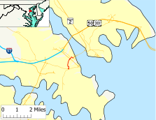
Route information Maintained by MDSHA Length: 1.16 mi[1] (1.87 km) Major junctions South end:  MD 450 in northwestern Annapolis
 MD 70 in northwestern Annapolis
 MD 436 in northwestern Annapolis
North end: MD 450 in western AnnapolisHighway system Maryland highway system
Interstate • US • State • Minor • Former • Turnpikes←  MD 425
MD 436 →Maryland Route 435 (MD 435) is a state highway in the U.S. state of Maryland. The route runs 1.16 mi (1.87 km) between two different intersections with Maryland Route 450, one in western Annapolis and the other in northwestern Annapolis. As a result, MD 435 serves as a bypass of Downtown Annapolis. In addition, the route is the main access for Navy-Marine Corps Memorial Stadium.
Contents
Route description
Maryland Route 435 begins as municipally-maintained Taylor Avenue at Westgate Circle on the west side of Annapolis. MD 435 is the north leg of the roundabout, whose other legs are Maryland Route 450 (West Street) west toward Parole and east toward the Annapolis Historic District, and Maryland Route 387 (Spa Road) to the south. The route heads north as a two-lane road with a speed limit of 30 mph (48 km/h), passing Annapolis National Cemetery to the west. After passing the headquarters of the Annapolis Police Department, MD 435 crosses the former right of way of the South Shore Division of the Washington, Baltimore and Annapolis Electric Railway and a future rail trail. At this point, the road transfers from municipal maintenance to state maintenance.
Soon after crossing the old railroad right of way, MD 435 passes Cedar Park Road, which leads to auxiliary entrances to Navy-Marine Corps Memorial Stadium, which is sited to the west of the road immediately afterwards. After passing some state offices on the east, the road intersects Maryland Route 70 (Roscoe Rowe Boulevard), which connects U.S. Route 50 and U.S. Route 301 to the Maryland State House and other state offices. East of MD 70, MD 435 passes Barracks J of the Maryland State Police and meets the southern terminus of Maryland Route 436 (Ridgely Avenue). The road then turns east onto Annapolis Street and soon after meets its northern terminus at MD 450 (King George Street) adjacent to the campus of the United States Naval Academy.
History
Maryland Route 435 was first paved in 1933 and was marked as MD 435 by 1939.[2] However, while the route has always followed Taylor Avenue, its routing in West Annapolis has changed over the years.[3] For more details on the routing in West Annapolis, see Maryland Route 436.
Junction list
The entire route is in Annapolis in Anne Arundel County.
Mile[1] Destinations Notes 0.00 MD 450 (West Street) – Parole, Downtown Annapolis
 MD 387 south (Spa Road)
Southern terminus 0.26 Old Washington, Baltimore and Annapolis Electric Railway right of way 0.33 Cedar Park Road 0.81 MD 70 (Roscoe Rowe Boulevard), Downtown Annapolis0.92 MD 436 north (Ridgely Avenue), West Annapolis0.99 Annapolis Street  turns south onto Annapolis Street
1.16 MD 450 (King George Street), Downtown AnnapolisNorthern terminus References
- ^ a b Maryland State Highway Administration (2008). "Highway Location Reference: Anne Arundel County" (PDF). http://apps.roads.maryland.gov/KeepingCurrent/performTrafficStudies/dataAndStats/hwyLocationRef/2008_hlr_all/co02.pdf. Retrieved 2010-01-14.
- ^ Maryland State Highway Administration (1933). "Map of Maryland" (PDF). http://commons.wikimedia.org/wiki/File:Maryland_State_Highway_Map_-_1933.pdf. Retrieved 2010-01-14.
- ^ Maryland State Highway Administration (1939). "Map of Maryland" (PDF). http://commons.wikimedia.org/wiki/File:Maryland_State_Highway_Map_-_1939.pdf. Retrieved 2010-01-14.
External links
Categories:- State highways in Maryland
- Roads in Anne Arundel County, Maryland


Wikimedia Foundation. 2010.