- Maryland Route 832
-
Maryland Route 832
Old Taneytown Road 
Route information Maintained by MDSHA Length: 7.67 mi[1] (12.34 km) Major junctions West end:  MD 140 in Taneytown
 MD 84 near Frizzelburg
East end: MD 140 near WestminsterLocation Counties: Carroll Highway system Maryland highway system
Interstate • US • State • Minor • Former • Turnpikes←  MD 831
MD 833  →
→Maryland Route 832 (MD 832) is a state highway in the U.S. state of Maryland. Known as Old Taneytown Road, the state highway runs 7.67 miles (12.34 km) from MD 140 near Taneytown east to MD 140 near Westminster. MD 832 is the old alignment of the highway now designated MD 140 in western Carroll County. The state highway was constructed as one of the original state roads in the mid-1910s and became part of MD 32 in 1927. MD 32 was replaced by MD 97 in 1956. MD 97 was moved to a new alignment between Westminster and Taneytown in the mid-1960s; the old alignment became part of MD 32 again. MD 832 replaced MD 32 on the highway in 1978, one year before the parallel highway became MD 140.
Contents
Route description
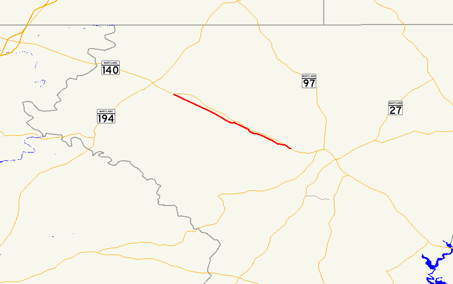
MD 832 begins at the Taneytown Roundabout just east of Taneytown. MD 140 heads northwest from the roundabout as Baltimore Street and east as Taneytown Pike. The fourth leg of the roundabout is Antrim Boulevard, which heads southwest as a county highway. MD 832 heads southeast as a two-lane road that passes through farmland and crosses Big Pipe Creek and Bear Branch. The state highway meets the northern end of MD 84 (Baust Church Road) and passes the eponymous church, Emmanuel Baust United Church of Christ, before heading through the hamlet of Tyrone. MD 832 continues through the village of Frizzelburg and the hamlet of Fountain Valley. The state highway closely parallels MD 140 (Taneytown Pike) for a short distance before MD 832 reaches its eastern terminus opposite Hughes Shop Road at Roop's Mill just west of Westminster.[1][2]
History
MD 832 is the old alignment of the highway now designated MD 140 from Taneytown to Westminster. The portion of the highway from Fountain Valley to its eastern terminus was originally part of the Westminster and Meadow Branch Turnpike.[3] The remainder of the highway was the Taneytown Road.[4] These two highways were designated for improvement as one of the original state roads by the Maryland State Roads Commission in 1909.[5] Taneytown Road was reconstructed as a 14-foot (4.3 m) wide concrete road from Fountain Valley through Frizzelburg in 1914 and from Frizzelburg to Taneytown in 1915. The turnpike was resurfaced in macadam shortly after 1915.[6] In 1927, the Taneytown–Westminster highway became one of the original state-numbered highways when it was designated part of MD 32, which originally ran from West Friendship in Howard County to Emmitsburg via Eldersburg, Westminster, and Taneytown.[7] MD 32 was widened to 20 feet (6.1 m) from Westminster to just east of Taneytown around 1930.[8]
In 1956, MD 97 was extended north from Howard County to Westminster, then assumed MD 32 northwest from there to Emmitsburg.[9] Construction on the new alignment of MD 97 from east of Fountain Valley to east of Taneytown began by 1964 and was completed in 1965.[10][11] The old alignment of MD 97 became a disjoint section of MD 32.[11] Old Taneytown Road's designation was changed to MD 832 in 1978.[12] The following year, U.S. Route 140 was decommissioned from Baltimore to Gettysburg. US 140 from Baltimore to Westminster became part of MD 140, which was extended west of Westminster along what had been MD 97 through Emmitsburg. MD 97 was moved to US 140's old route north of Westminster toward Gettysburg.[13] The Taneytown Roundabout at MD 832's western terminus was constructed in 1996.[14]
Junction list
The entire route is in Carroll County.
Location Mile
[1]Destinations Notes Taneytown 0.00 MD 140 (Taneytown Pike/Baltimore Street) / Antrim Boulevard west – Westminster, EmmitsburgWestern terminus; Taneytown Roundabout Frizzelburg 3.13 MD 84 south (Baust Church Road) – Uniontown, New WindsorWestminster 7.67 MD 140 (Taneytown Pike) / Hughes Shop Road north – BaltimoreEastern terminus 1.000 mi = 1.609 km; 1.000 km = 0.621 mi References
- ^ a b c "Highway Location Reference: Carroll County" (PDF). Maryland State Highway Administration. 2009. http://www.marylandroads.com/Location/2009_CARROLL.pdf. Retrieved 2011-04-29.
- ^ Google, Inc. Google Maps – Maryland Route 832 (Map). Cartography by Google, Inc. http://maps.google.com/maps?f=d&source=s_d&saddr=Old+Taneytown+Rd&daddr=Old+Taneytown+Rd&hl=en&geocode=FWn6XAId_rdm-w%3BFREgXAIdwYxo-w&mra=ls&sll=39.646643,-77.153034&sspn=0.003726,0.009645&ie=UTF8&ll=39.626317,-77.072525&spn=0.11926,0.308647&t=h&z=12. Retrieved 2011-04-29.
- ^ Clark, William Bullock (1899). Report on the Highways of Maryland. Baltimore: Maryland Geological Survey. p. 224. http://books.google.com/books?id=b9l9AAAAIAAJ&printsec=frontcover#v=onepage&q&f=false. Retrieved 2011-04-29.
- ^ United States Geological Survey. Taneytown, MD quadrangle (Map). 1:48,000. 15 Minute Series (Topographic) (1911 ed.). http://historical.mytopo.com/quad.cfm?quadname=Taneytown&state=MD&series=15. Retrieved 2011-04-29.
- ^ Maryland Geological Survey. Map of Maryland (Map) (1910 ed.).
- ^ Report of the State Roads Commission of Maryland. 1912-1915. Baltimore: Maryland State Roads Commission. May 1915. pp. 50, 106. http://www.archive.org/details/annualreportsofs1912mary. Retrieved 2011-04-29.
- ^ Maryland Geological Survey. Map of Maryland: Showing State Road System and State Aid Roads (Map) (1927 ed.).
- ^ Report of the State Roads Commission of Maryland. 1927-1930. Baltimore: Maryland State Roads Commission. 1930-10-01. p. 82. http://www.archive.org/details/reportofstateroa1927mary. Retrieved 2011-04-29.
- ^ Maryland State Roads Commission. Maryland: Official Highway Map (Map) (1956 ed.).
- ^ Maryland State Roads Commission. Maryland: Official Highway Map (Map) (1964 ed.).
- ^ a b Maryland State Roads Commission. Maryland: Official Highway Map (Map) (1965 ed.).
- ^ Maryland State Highway Administration. Maryland: Official Highway Map (Map) (1978 ed.).
- ^ Maryland State Highway Administration. Maryland: Official Highway Map (Map) (1979-80 ed.).
- ^ Niederhauser, Mike (March 2002). "Modern Roundabouts in Maryland" (PDF). Maryland State Highway Administration. http://www.alaskaroundabouts.com/RABCHART4.pdf. Retrieved 2011-04-29.
External links
Roads in Carroll County, Maryland State highways 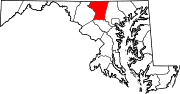
U.S. Highways Interstate Highways Categories:- State highways in Maryland
- Roads in Carroll County, Maryland


Wikimedia Foundation. 2010.