- Maryland Route 77
-
Maryland Route 77
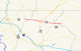
Route information Maintained by MDSHA Length: 20.74 mi[1][2][3] (33.38 km) Major junctions West end:  MD 64 in Smithsburg
 US 15 in Thurmont
 MD 550 in Thurmont
 MD 76 in Rocky Ridge
East end:  MD 194 in Keymar
Location Counties: Washington, Frederick, Carroll Highway system Maryland highway system
Interstate • US • State • Minor • Former • Turnpikes← MD 76MD 78  →
→Maryland Route 77 (MD 77) is a state highway in the U.S. state of Maryland. The state highway runs 20.74 miles (33.38 km) from MD 64 in Smithsburg east to MD 194 in Keymar. MD 77 is the main east–west highway of northern Frederick County. The state highway connects Thurmont with eastern Washington County via Foxville, which lies between South Mountain and Catoctin Mountain near Catoctin Mountain Park and Cunningham Falls State Park. MD 77 links Thurmont with western Carroll County through the communities of Graceham, Rocky Ridge, and Detour in the Monocacy River valley. MD 77 was constructed from Thurmont east to Detour in the 1920s and early 1930s. A disjoint section of MD 77 was built between Cavetown and Foxville in the late 1930s. The portions of the modern highway between Foxville and Thurmont and from Detour to Keymar were county highways until they were designated part of MD 77 in 1956. MD 77's western terminus was moved east to MD 64 in Smithsburg in 1960.
Contents
Route description
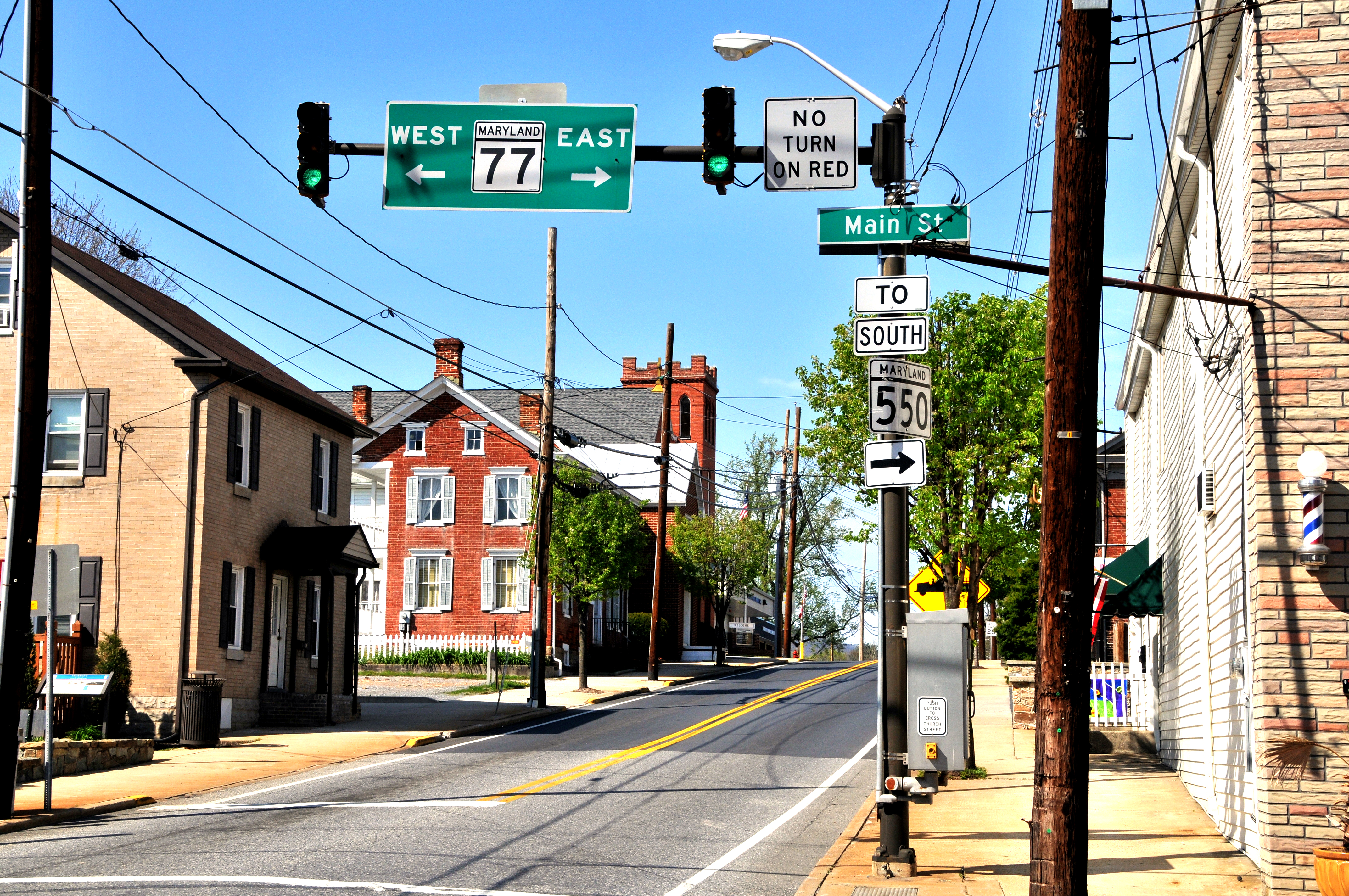
 MD 77 in Thurmont
MD 77 begins at an intersection with MD 64 (Smithsburg Pike) in Smithsburg. The roadway continues northwest as county-maintained Leitersburg Smithsburg Road into the town of Smithsburg, where it becomes that town's Main Street, then continues northwest to Leitersburg. MD 77's first intersection east of MD 64 is Wolfsville Road, which becomes MD 17 at the Washington–Frederick county line and heads into the Middletown Valley. MD 77 heads east as Foxville Road, a two-lane road that passes through several sharp curves as the highway ascends South Mountain. The state highway passes Pleasant Valley Road before it reaches its highest point at the Washington–Frederick County line.[4][1] East of Foxville, MD 77 begins to follows the boundary between Cunningham Falls State Park to the south and the National Park Service-managed Catoctin Mountain Park to the north. Catoctin Mountain Park contains three historic camps: Camp Greentop, Camp Misty Mount, and the Presidential retreat Camp David.[4][2]
MD 77 follows a curvaceous route along the narrow valley of Hunting Creek to descend Catoctin Mountain. The state highway emerges from the mountain valley just west of the town of Thurmont, where the highway becomes Main Street and meets U.S. Route 15 (Catoctin Mountain Highway) at a folded diamond interchange. MD 77 intersects Church Street and Water Street in the center of town; Church Street heads north as MD 550. The two state highways run concurrently through the eastern part of Thurmont until MD 550 heads south as Jimtown Road and MD 77 continues east as Rocky Ridge Road. MD 77 leaves the town of Thurmont and passes through the village of Graceham, where the highway passes Graceham Moravian Church and Parsonage and has a one-lane underpass of the Maryland Midland Railroad. The state highway passes through farmland and traverses Owens Creek just west of Old Frederick Road, which crosses the creek to the south on the Loys Station Covered Bridge. Another historic bridge across Owens Creek, the Old Mill Road Bridge, is accessed by Old Mill Road just east of Loyds Station.[4][2]
MD 77 passes under the railroad again just west of Rocky Ridge, where the highway meets the southern end of MD 76 (Motters Station Road). The state highway crosses the Monocacy River on a through truss bridge at Millers Bridge just south of the confluence of the Monocacy River and Double Pipe Creek.[4][2] A short distance to the east, MD 77 crosses Double Pipe Creek and enters Carroll County at the village of Detour, which is located just north of the confluence of Big Pipe Creek and Little Pipe Creek to form Double Pipe Creek. The state highway continues east as Middleburg Road, which intersects the Maryland Midland Railroad at grade and crosses Big Pipe Creek before reaching its eastern terminus at MD 194 (Francis Scott Key Memorial Highway) in the village of Keymar, which sits at the junction of the Maryland Midland Railroad's east–west and north–south rail lines. Middleburg Road continues east as a county highway that passes through Middleburg and Uniontown before continuing as Uniontown Road toward Westminster.[4][3]
History
The first section of what was to become MD 77 was paved in concrete from the railroad crossing at Graceham east to Old Frederick Road near Loys Station by 1923.[5] This section of improved road was extended east with concrete to Rocky Ridge starting in 1924 and completed by 1927.[6][7] MD 77 was also extended west to the eastern edge of Thurmont as a macadam road by 1927.[7] The concrete highway was extended east 1 mile (1.6 km) from Rocky Ridge in 1928 and to the Monocacy River in 1930.[8][9] MD 77 was extended east to the Frederick–Carroll county line at Double Pipe Creek just west of Detour starting in 1930.[10] The state highway's truss bridge over the Monocacy River was built in 1932, replacing an old truss bridge of the same design as one that had catastrophically failed on US 240's (now MD 355) crossing of the Baltimore & Ohio Railroad in 1930.[11]
MD 77 was connected to US 15 in Thurmont by municipally-maintained Main Street and from Detour to MD 71 (now MD 194) in Keymar by a county connecting road.[12] The first portion of the western half of MD 77 was built between 1936 and 1938 from Cavetown to Foxville.[13][14] The westernmost part of MD 77 included Cavetown Church Road from MD 64 (now MD 66) in Cavetown to just east of Wolfsville Road. The two sections of MD 77 were connected by county-maintained Foxville Road from Foxville to Thurmont.[15] Foxville Road between Foxville and Thurmont and Middleburg Road from Double Pipe Creek east to MD 194 became part of MD 77 in 1956.[16] MD 77 was widened through Thurmont that same year.[17]
In 1956, construction began on MD 77's interchange with the US 15 bypass, which opened in 1958.[17][18] The US 15 interchange originally consisted of one two-way ramp in the northeast quadrant of the junction between MD 77 and the two-lane bypass.[19] When US 15 was expanded to a four-lane divided highway in 1985, the southbound US 15 ramps in the southwest quadrant of the junction were constructed.[20][21] MD 77's western terminus was moved from Cavetown to the Smithsburg Bypass when MD 64 was moved to the new highway in 1960.[22] The old alignment of MD 77 west to Cavetown consists of Cavetown Church Road, which is unsigned MD 844 between MD 64 and a dead end adjacent to modern MD 77 east of Wolfsville Road.[1]
Junction list
County Location Mile
[1][2][3]Destinations Notes Washington Smithsburg 0.00 MD 64 (Smithsburg Pike) / Leitersburg Smithsburg Road west – Hagerstown, WaynesboroWestern terminus Frederick Thurmont 10.10 US 15 (Catoctin Mountain Highway) – Frederick, GettysburgInterchange 10.47 MD 550 north (Church Street) / Water Street south – SabillasvilleWest end of concurrency with MD 550 11.46 MD 550 south (Jimtown Road) – Creagerstown, WoodsboroEast end of concurrency with MD 550 Rocky Ridge 15.99 MD 76 north (Motters Station Road) / Longs Mill Road south – EmmitsburgCarroll Keymar 20.74 MD 194 (Francis Scott Key Highway) / Middleburg Road east – Taneytown, Woodsboro, MiddleburgEastern terminus 1.000 mi = 1.609 km; 1.000 km = 0.621 mi References
- ^ a b c d "Highway Location Reference: Washington County" (PDF). Maryland State Highway Administration. 2009. http://www.marylandroads.com/Location/2009_WASHINGTON.pdf. Retrieved 2011-04-07.
- ^ a b c d e "Highway Location Reference: Frederick County" (PDF). Maryland State Highway Administration. 2009. http://www.marylandroads.com/Location/2009_FREDERICK.pdf. Retrieved 2011-04-07.
- ^ a b c "Highway Location Reference: Carroll County" (PDF). Maryland State Highway Administration. 2009. http://www.marylandroads.com/Location/2009_CARROLL.pdf. Retrieved 2011-04-07.
- ^ a b c d e Google, Inc. Google Maps – Maryland Route 77 (Map). Cartography by Google, Inc. http://maps.google.com/maps?f=d&source=s_d&saddr=S+Main+St&daddr=MD-77+E%2FMiddleburg+Rd&hl=en&geocode=FdT-XAIdrGZg-w%3BFWBLXAIdOnRl-w&mra=ls&sll=39.603308,-77.239616&sspn=0.007456,0.01929&ie=UTF8&t=h&z=11. Retrieved 2011-04-07.
- ^ Maryland Geological Survey. Map of Maryland: Showing State Road System and State Aid Roads (Map) (1923 ed.).
- ^ Report of the State Roads Commission of Maryland. 1924-1926. Baltimore: Maryland State Roads Commission. January 1927. pp. 48, 84. http://www.archive.org/details/annualreportsofs1924mary. Retrieved 2011-04-15.
- ^ a b Maryland Geological Survey. Map of Maryland: Showing State Road System and State Aid Roads (Map) (1927 ed.).
- ^ Maryland Geological Survey. Map of Maryland: Showing State Road System and State Aid Roads (Map) (1928 ed.).
- ^ Maryland Geological Survey. Map of Maryland Showing State Road System: State Aid Roads and Improved County Road Connections (Map) (1930 ed.).
- ^ Report of the State Roads Commission of Maryland. 1927-1930. Baltimore: Maryland State Roads Commission. 1930-10-01. p. 210. http://www.archive.org/details/reportofstateroa1927mary. Retrieved 2011-04-15.
- ^ Report of the State Roads Commission of Maryland. 1931-1934. Baltimore: Maryland State Roads Commission. 1934-12-28. p. 44. http://www.archive.org/details/reportofstateroa1931mary. Retrieved 2011-04-15.
- ^ Maryland Geological Survey. Map of Maryland Showing State Road System: State Aid Roads and Improved County Road Connections (Map) (1933 ed.).
- ^ Report of the State Roads Commission of Maryland. 1935-1936. Baltimore: Maryland State Roads Commission. 1936-12-04. p. 255. http://www.archive.org/details/reportofstateroa1935mary. Retrieved 2011-04-15.
- ^ Report of the State Roads Commission of Maryland. 1937-1938. Baltimore: Maryland State Roads Commission. 1939-03-04. p. 123. http://www.archive.org/details/reportofstateroa1937mary. Retrieved 2011-04-15.
- ^ Maryland State Roads Commission. General Highway Map: State of Maryland (Map) (1939 ed.).
- ^ Maryland State Roads Commission. Maryland: Official Highway Map (Map) (1956 ed.).
- ^ a b Report of the State Roads Commission of Maryland. 1955-1956. Baltimore: Maryland State Roads Commission. 1956-11-02. pp. 204–205. http://www.archive.org/details/reportofstateroa1955mary. Retrieved 2011-04-15.
- ^ Maryland State Roads Commission. Maryland: Official Highway Map (Map) (1958 ed.).
- ^ United States Geological Survey (1981-07-01). Thurmont, Maryland, United States (Map). Topo Map. http://msrmaps.com/image.aspx?T=2&S=12&Z=18&X=366&Y=5487&W=2. Retrieved 2011-04-15.
- ^ Maryland State Highway Administration. Maryland: Official Highway Map (Map) (1985-86 ed.).
- ^ "NBI Structure Number: 100000100180010". National Bridge Inventory. http://nationalbridges.com/nbi_record.php?StateCode=24&struct=100000100180010. Retrieved 2011-04-15.
- ^ Maryland State Roads Commission. Maryland: Official Highway Map (Map) (1960 ed.).
External links
Roads in Carroll County, Maryland State highways 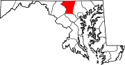
U.S. Highways Interstate Highways Roads in Frederick County, Maryland State highways 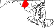
U.S. Highways Interstate Highways Roads in Washington County, Maryland State highways 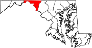
U.S. Highways Interstate Highways Categories:- State highways in Maryland
- Roads in Carroll County, Maryland
- Roads in Frederick County, Maryland
- Roads in Washington County, Maryland


Wikimedia Foundation. 2010.