- Maryland Route 88
-
Maryland Route 88
Lower Beckleysville Road, Blackrock Road 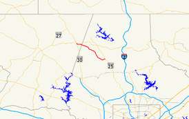
Route information Maintained by MDSHA Length: 8.01 mi[1][2] (12.89 km) Major junctions West end: 
 MD 30 Bus. in Hampstead
 MD 833 in Hampstead
East end:  MD 25 near Butler
Highway system Maryland highway system
Interstate • US • State • Minor • Former • Turnpikes←  MD 87
MD 87MD 89  →
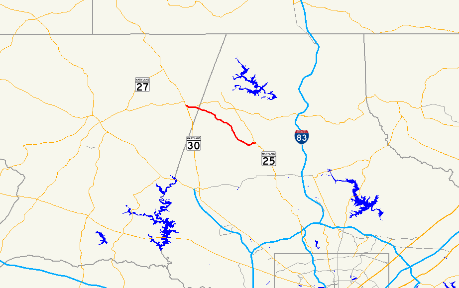
→Maryland Route 88 is a 8.01-mile (12.89 km) state highway in the U.S. state of Maryland, located in Carroll County and Baltimore County. It is a simple two-lane road, beginning at its western terminus at Main Street (MD 30 Business) in Hampstead and ending at its eastern terminus at Falls Road (MD 25) in Butler.
Contents
Route description
Maryland Route 88 starts off as Lower Beckleysville Road at Maryland Route 30 Business (Main Street) in Hampstead. After three blocks within the town, it curves to the northeast and features a roundabout with Blackrock Road and Maryland Route 833. MD 88 leaves the roundabout to the east on Blackrock Road, following a thin two-lane road as it quickly crosses the Baltimore County line.[2][3] Through here, the route follows mostly open countryside, featuring a mix of homes and forest patches as well as it cuts through the open country on a gently curvy alignment, intersecting several connecting roads in the process but not providing access to major population centers. Just before it meets its eastern end at Maryland Route 25, better known as Falls Road, the route curves 90 degrees and travels to the northeast through another small patch of forest for a short stretch. The end of the road is located to the north of Butler.[1][3]
Junction list
County Location Mile
[1][2]Roads intersected Notes Carroll Hampstead 0.00
MD 30 Bus. (South Main Street) – Reisterstown, Manchester, Hanover, PAWestern terminus 0.68 MD 833 west (Old Blackrock Road)roundabout Baltimore Butler 8.01 MD 25 (Falls Road)Eastern terminus References
- ^ a b c Maryland State Highway Administration (2008). "Highway Location Reference: Baltimore County" (PDF). http://apps.roads.maryland.gov/KeepingCurrent/performTrafficStudies/dataAndStats/hwyLocationRef/2008_hlr_all/co03.pdf. Retrieved 2010-02-27.
- ^ a b c Maryland State Highway Administration (2008). "Highway Location Reference: Carroll County" (PDF). http://apps.roads.maryland.gov/KeepingCurrent/performTrafficStudies/dataAndStats/hwyLocationRef/2008_hlr_all/co06.pdf. Retrieved 2010-02-27.
- ^ a b Google, Inc. Google Maps – overview of Maryland Route 88 (Map). Cartography by Google, Inc. http://maps.google.com/maps?f=d&source=s_d&saddr=maryland+30+and+maryland+88+hampstead,+md&daddr=maryland+25+and+maryland+88+butler,+md&hl=en&geocode=FW9JXAIdcWBr-ykpx-J_tUHIiTF9g5JRpTmflQ%3BFWVzWwIdiQJt-yn_XBomU2vIiTGN5IH7oLPO4g&mra=ls&sll=37.0625,-95.677068&sspn=31.839416,86.572266&ie=UTF8&t=h&z=13. Retrieved 2010-04-22.
External links
Categories:- State highways in Maryland
- Roads in Carroll County, Maryland
- Roads in Baltimore County, Maryland

Wikimedia Foundation. 2010.