- Maryland Route 258
-
Maryland Route 258
Bay Front Road 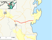
Route information Maintained by MDSHA Length: 7.13 mi[1] (11.47 km) Major junctions West end: Wrighton Road in Bristol  MD 4 in Bristol
 MD 2 in Tracys Landing
East end:  MD 256 in Deale
Highway system Maryland highway system
Interstate • US • State • Minor • Former • Turnpikes←  MD 257
MD 259  →
→Maryland Route 258 (MD 258) is a state highway in the U.S. state of Maryland. Known as Bay Front Road, the route runs 7.13 mi (11.47 km) from Wrighton Road in Bristol east to Maryland Route 256 in Deale.
Contents
Route description
Maryland Route 258 begins at an intersection with Wrighton Road, a county-maintained road, and an off-ramp from Maryland Route 4 (Southern Maryland Boulevard) south. This intersection is 50 ft (15 m) from Southern Maryland Boulevard, a frontage road to the modern MD 4. After passing a park and ride, an on-ramp to MD 4 south leaves to the south and MD 258 crosses the MD 4 expressway. The next intersection is with Maryland Route 794 (Southern Maryland Boulevard), which parallels MD 4 north toward Drury. An off-ramp from MD 4 north arrives at the same intersection. Heading north on MD 794 leads to an on-ramp to MD 4 north and Maryland Route 259 (Greenock Road).
MD 258 heads east from the MD 4 interchange as a two-lane road with a speed limit of 50 mph (80 km/h). The road heads east through an area of forest, scattered residences, and farms, including horse farms, within which the road passes Little Road. A little further east is the intersection of McKendree Road, where the old alignment of MD 258, unsigned MD 796A, splits off to the north and shortly returns. MD 258 encounters Brookswood Road and crosses Lyons Creek before meeting Maryland Route 2 (Solomons Island Road) at a signalized intersection where MD 258 temporarily expands to four lanes.
After crossing MD 2, MD 258 continues east as a two-lane road with a speed limit of 50 mph (80 km/h). Compared to the stretch of MD 258 west of MD 2, this segment cuts straight through the gently rolling hills as it beelines to the east. After crossing Traceys Creek, the road crosses Franklin Gibson Road and Nutwell Sudley Road and passes through farmland. Shortly after meeting the northern end of Rockhold Creek Road, which heads south to the center of Deale, MD 258 crosses Rockhold Creek on a level bridge, then intersects Swamp Circle Road. The route then passes through forest before meeting its eastern end in a roundabout at Maryland Route 256 (Deale Churchton Road) between the referenced two communities.
History
The part of Maryland Route 258 west of Maryland Route 2 was paved by 1933.[2] The 1939 Maryland state highway map shows only this stretch as MD 258.[3] The straight eastern stretch was built on a new alignment in the 1960s.[4] The roundabout at the eastern terminus was completed in 2007.[5]
Junction list
The entire route is in Anne Arundel County.
Location Mile[1] Destinations Notes Bristol 0.00 Wrighton Road Western terminus 0.17 MD 4 south (Southern Maryland Boulevard) – Prince Frederick0.29  MD 794 north (Southern Maryland Boulevard) – Drury
TO north - Upper Marlboro
TO
north - Lothian1.74 Little Road 2.83 McKendree Road Tracys Landing 3.69 Brookswood Road 4.26 MD 2 (Solomons Island Road) – Annapolis, Prince FrederickDeale 5.71 Franklin Gibson Road / Nutwell Sudley Road 6.29 Rockhold Creek Road 6.65 Swamp Circle Road 7.13 MD 256 (Deale Churchton Road) – Deale, ChurchtonEastern terminus Roundabout
References
- ^ a b Maryland State Highway Administration (2008). "Highway Location Reference: Anne Arundel County" (PDF). http://apps.roads.maryland.gov/KeepingCurrent/performTrafficStudies/dataAndStats/hwyLocationRef/2008_hlr_all/co02.pdf. Retrieved 2010-01-09.
- ^ Maryland State Highway Administration (1933). "Map of Maryland" (PDF). http://commons.wikimedia.org/wiki/File:Maryland_State_Highway_Map_-_1933.pdf. Retrieved 2010-01-08.
- ^ Maryland State Highway Administration (1939). "Map of Maryland" (PDF). http://commons.wikimedia.org/wiki/File:Maryland_State_Highway_Map_-_1939.pdf. Retrieved 2010-01-09.
- ^ Maryland State Highway Administration (1970). "Map of Maryland" (PDF). http://commons.wikimedia.org/wiki/File:Maryland_State_Highway_Map_-_1970.pdf. Retrieved 2010-01-09.
- ^ Ben Miller (2008). "When is the Safest Distance Not a Straight Line?" (PDF). http://www.bayweekly.com/year08/issuexvi50/lead_1.html. Retrieved 2010-01-09.[dead link]
External links
Categories:- State highways in Maryland
- Roads in Anne Arundel County, Maryland


Wikimedia Foundation. 2010.