- Maryland Route 423
-
Maryland Route 423
Fairhaven Road 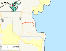
Route information Maintained by MDSHA Length: 2.79 mi[1] (4.49 km) Major junctions West end:  MD 2 in Friendship
East end: Arundel Road in Fairhaven Highway system Maryland highway system
Interstate • US • State • Minor • Former • Turnpikes←  MD 422
MD 424  →
→Maryland Route 423 (MD 423) is a state highway in the U.S. state of Maryland. Known as Fairhaven Road, the route runs 2.75 mi (4.43 km) from Maryland Route 2 in Friendship east to Arundel Road in Fairhaven.
Contents
Route description
Maryland Route 423 begins at Maryland Route 2 (Solomons Island Road) in the unincorporated area of Friendship. Jewell Road heads west from the same intersection. After passing Old Solomons Island Road, MD 423 heads east as a two-lane road with a speed limit of 40 mph (64 km/h) through an area of farms and scattered residences. The road next passes Franklin Gibson Road, which heads north towards Deale. Right before reaching Herring Bay, the road reaches an intersection with Town Point Road, which serves the marina of the same name to the north. At this intersection, MD 423 turns sharply to the south and the speed limit drops to 30 mph (48 km/h). After passing the residential community of Fairhaven, the road crosses an inlet of Herring Bay and comes to an end at Arundel Road, a residential street. Fairhaven Road continues south as a county-maintained road toward Maryland Route 261 (Friendship Road).
History
Maryland Route 423 was first paved in 1933.[2] The 1939 Maryland state highway map shows MD 423 marked along its present course.[3]
Junction list
The entire route is in Anne Arundel County.
Location Mile[1] Destinations Notes Friendship 0.00 MD 2 (Solomons Island Road) – Annapolis, Prince Frederick
Jewell Road
Western terminus 0.29 Old Solomons Island Road 0.84 Franklin Gibson Road Fairhaven 1.87 Town Point Road 2.79 Arundel Road Fairhaven Road
Eastern terminus To
 MD 261
References
- ^ a b Maryland State Highway Administration (2008). "Highway Location Reference: Anne Arundel County" (PDF). http://apps.roads.maryland.gov/KeepingCurrent/performTrafficStudies/dataAndStats/hwyLocationRef/2008_hlr_all/co02.pdf. Retrieved 2010-01-14.
- ^ Maryland State Highway Administration (1933). "Map of Maryland" (PDF). http://commons.wikimedia.org/wiki/File:Maryland_State_Highway_Map_-_1933.pdf. Retrieved 2010-01-14.
- ^ Maryland State Highway Administration (1939). "Map of Maryland" (PDF). http://commons.wikimedia.org/wiki/File:Maryland_State_Highway_Map_-_1939.pdf. Retrieved 2010-01-14.
External links
Categories:- State highways in Maryland
- Roads in Anne Arundel County, Maryland


Wikimedia Foundation. 2010.