- Maryland Route 436
-
Maryland Route 436
Ridgely Avenue 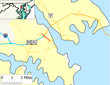
Maryland Route 436 highlighted in redRoute information Maintained by MDSHA Length: 1.14 mi[1] (1.83 km) Major junctions South end:  MD 435 in northwestern Annapolis
North end: Bestgate Road in western Annapolis Highway system Maryland highway system
Interstate • US • State • Minor • Former • Turnpikes← MD 435MD 439  →
→Maryland Route 436 (MD 436) is a state highway in the U.S. state of Maryland. Known as Ridgely Avenue, the route runs 1.14 mi (1.83 km) from Maryland Route 435 in Annapolis to Bestgate Road in West Annapolis.
Contents
Route description
Maryland Route 436 begins at an intersection with Maryland Route 435 (Taylor Avenue) near the campus of the United States Naval Academy. The route heads northwest as a two-lane road with a speed limit of 30 mph (48 km/h) through a commercial area. After passing Melvin Avenue, MD 436 transitions to a residential area. The road then crosses Weems Creek on a drawbridge. After crossing the creek, the speed limit increases to 35 mph (56 km/h). MD 436 then passes Riverview Avenue, which is unsigned Maryland Route 783, crosses over U.S. Route 50 and U.S. Route 301 (John Hanson Highway), and passes Acorn Drive, which is unsigned Maryland Route 784. MD 436 meets its northern terminus at Bestgate Road, which heads west to intersect Maryland Route 70 and Maryland Route 178.
History
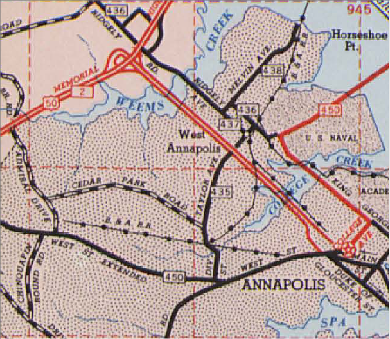
 West Annapolis on the 1956 Maryland State highway map.
The history of Maryland Route 436 is inextricably tied with the other state routes in West Annapolis, the current Maryland Route 435 and former MD 437 and MD 438. All four routes were paved by 1933.[2] By 1946, MD 435 turned north on Annapolis Street from the north end of Taylor Avenue, then turned east on Severn Avenue (now Melvin Avenue), while MD 438 followed Revell Street and West Annapolis Avenue (both streets now Ridgely Avenue).[3] The 1950 Maryland state highway map implicitly suggests MD 436 was Annapolis Street between King George Street (then U.S. Route 50, now MD 450) and MD 435, while MD 437 was the block of Severn Avenue between MD 435 and MD 438.[4]
In 1954, MD 436 was on Annapolis Avenue from King George Street (MD 450) to Severn Avenue, headed west on Severn for one block, then went north on Revell Street and West Annapolis Avenue.[5] Severn Avenue to the east of MD 436 was MD 438. MD 437 was the segment of Revell Street between MD 435 (Taylor Avenue) and MD 436. The 1956 map explicitly confirms these routings, as well as includes as unnumbered state routes ramps to the new U.S. Route 50 expressway, the remnants of which are MD 783 and MD 784 today.[6][1] Sometime in the 1970s, MD 437 and MD 438 were removed from the state route system and MD 435 and MD 436 were moved to their present courses.[7] The ramps from MD 436 to and from U.S. Route 50 and 301 were removed in the late 1980s as part of the project to transform U.S. 50-301 from an expressway to a freeway east of Maryland Route 70.[8]
Junction list
The entire route is in Annapolis in Anne Arundel County.
Mile[1] Destinations Notes 0.00 MD 435 (Taylor Avenue)Southern terminus 0.20 Melvin Avenue 0.51 Weems Creek drawbridge 0.72 Riverview Avenue Unsigned MD 783 0.92 Crosses over 
 US 50/US 301 with no access
0.97 Acorn Drive Unsigned MD 784 1.14 Bestgate Road Northern terminus References
- ^ a b c Maryland State Highway Administration (2008). "Highway Location Reference: Anne Arundel County" (PDF). http://apps.roads.maryland.gov/KeepingCurrent/performTrafficStudies/dataAndStats/hwyLocationRef/2008_hlr_all/co02.pdf. Retrieved 2010-01-14.
- ^ Maryland State Highway Administration (1933). "Map of Maryland" (PDF). http://commons.wikimedia.org/wiki/File:Maryland_State_Highway_Map_-_1933.pdf. Retrieved 2010-01-14.
- ^ Maryland State Highway Administration (1946). "Map of Maryland" (PDF). http://commons.wikimedia.org/wiki/File:Maryland_State_Highway_Map_-_1946.pdf. Retrieved 2010-01-14.
- ^ Maryland State Highway Administration (1950). "Map of Maryland" (PDF). http://commons.wikimedia.org/wiki/File:Maryland_State_Highway_Map_-_1950.pdf. Retrieved 2010-01-14.
- ^ Maryland State Highway Administration (1954). "Map of Maryland" (PDF). http://commons.wikimedia.org/wiki/File:Maryland_State_Highway_Map_-_1954.pdf. Retrieved 2010-01-14.
- ^ Maryland State Highway Administration (1956). "Map of Maryland" (PDF). http://commons.wikimedia.org/wiki/File:Maryland_State_Highway_Map_-_1956.pdf. Retrieved 2010-01-14.
- ^ Maryland State Highway Administration (1980). "Map of Maryland" (PDF). http://commons.wikimedia.org/wiki/File:Maryland_State_Highway_Map_-_1980.pdf. Retrieved 2010-01-14.
- ^ Steve Anderson. "John Hanson Highway (US 50, US 301, and I-595)". http://www.dcroads.net/roads/I-595_MD/. Retrieved 2010-01-14.
External links
Categories:- State highways in Maryland
- Roads in Anne Arundel County, Maryland


Wikimedia Foundation. 2010.