- Maryland Route 422
-
Maryland Route 422
Bayard Road 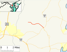
Maryland Route 422 highlighted in redRoute information Maintained by MDSHA Length: 3.04 mi[1] (4.89 km) Major junctions West end: Polling House Road in Bayard East end:  MD 2 in Lothian
Highway system Maryland highway system
Interstate • US • State • Minor • Former • Turnpikes←  MD 418
MD 423  →
→Maryland Route 422 (MD 422) is a state highway in the U.S. state of Maryland. Known as Bayard Road, the route runs 3.04 mi (4.89 km) from Polling House Road near Bayard east to Maryland Route 2 in Lothian.
Contents
Route description
Maryland Route 422 begins at Polling House Road east of the hamlet of Bayard. Bayard Road continues west through Bayard to Sands Road, which parallels the Patuxent River. The route heads east as a two-lane road with a speed limit of 40 mph (64 km/h) through farmland. After passing South Polling House Road, which meets Polling House Road in Harwood, the route turns southeast toward Lothian. MD 422 meets its terminus as the north leg of the Lothian Roundabout, which also features Maryland Route 408 (Mount Zion Road) as the west leg and Maryland Route 2 (Solomons Island Road) as the south and east legs.
History
Maryland Route 422 was first paved in 1933.[2] The 1939 Maryland state highway map shows MD 422 marked along its present course.[3]
Junction list
The entire route is in Anne Arundel County.
Location Mile[1] Destinations Notes Bayard 0.00 Polling House Road Western terminus Lothian 1.91 South Polling House Road 3.04 MD 2 (Solomons Island Road) – Annapolis, Prince Frederick
 MD 408 west (Mount Zion Road) – Upper Marlboro
Eastern terminus Roundabout
References
- ^ a b Maryland State Highway Administration (2008). "Highway Location Reference: Anne Arundel County" (PDF). http://apps.roads.maryland.gov/KeepingCurrent/performTrafficStudies/dataAndStats/hwyLocationRef/2008_hlr_all/co02.pdf. Retrieved 2010-01-14.
- ^ Maryland State Highway Administration (1933). "Map of Maryland" (PDF). http://commons.wikimedia.org/wiki/File:Maryland_State_Highway_Map_-_1933.pdf. Retrieved 2010-01-14.
- ^ Maryland State Highway Administration (1939). "Map of Maryland" (PDF). http://commons.wikimedia.org/wiki/File:Maryland_State_Highway_Map_-_1939.pdf. Retrieved 2010-01-14.
External links
Categories:- State highways in Maryland
- Roads in Anne Arundel County, Maryland


Wikimedia Foundation. 2010.