- Maryland Route 256
-
Maryland Route 256
Deale Road, Deale Churchton Road 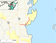
Route information Maintained by MDSHA Length: 4.21 mi[1] (6.78 km) Major junctions West end:  MD 2 in Tracys Landing
 MD 258 in Deale
East end:  MD 468 in Churchton
Highway system Maryland highway system
Interstate • US • State • Minor • Former • Turnpikes←  MD 255
MD 257  →
→Maryland Route 256 (MD 256) is a state highway in the U.S. state of Maryland. The route runs 5.28 mi (8.50 km) from Maryland Route 2 in Tracys Landing east to Maryland Route 468 in Churchton.
Contents
Route description
Maryland Route 256 begins at an intersection with Maryland Route 2 (Solomons Island Road) in Tracys Landing. After passing Deale-Tracys Park, the route heads east as a two-lane road with a speed limit of 45 mph (72 km/h) through an area of forests, farms, and scattered residences, within which the road crosses Franklin Gibson Road at an oblique angle. After passing the entrance to two of the many marinas around Deale, the road crosses Traceys Creek and turns to the north. After encountering more marinas and a speed drop to 30 mph (48 km/h), MD 256 reaches the intersection of Rockhold Creek Road, where MD 255 turns east to continue on Deale Road and cross Rockhold Creek.
MD 256 continues east through the unincorporated village of Deale until it passes Drum Point Road and meets Masons Beach Road. The latter road continues straight, while MD 256 has a 90-degree turn to the north onto Deale Churchton Road. After passing the South County Branch Library, the speed limit increases to 40 mph (64 km/h) and the road runs through an area of residences and marina-related shops, as well as Mimosa Cove Road and Swamp Circle Road. The road continues north until the roundabout at which MD 256 encounters Maryland Route 258 (Bay Front Road), which is surrounded by some commercial establishments. After the roundabout, the road passes Deale Beach Road and enters an area of forest and scattered residences. Within the unincorporated village of Churchton, MD 256 meets Franklin Manor Road. The road then heads north through a sparsely settled area until it reaches its terminus at a traffic signal at Maryland Route 458. MD 458 heads west as Muddy Creek Road and east as Shady Side Road.
History
Maryland Route 256 was paved from MD 2 to Traceys Creek on the west side of Deale in 1927.[2] The entire route was paved by 1933.[3] The 1939 Maryland state highway map shows MD 256 assigned to its present course.[4] The roundabout at the MD 258 junction was completed in 2007.[5]
Junction list
The entire route is in Anne Arundel County.
Location Mile[1] Destinations Notes Tracys Landing 0.00 MD 2 (Solomons Island Road) – Annapolis, Prince FrederickWestern terminus 0.74 Franklin Gibson Road Deale 2.22 Rockhold Creek Road 2.53 Drum Point Road 2.58 Masons Beach Road  turns north on Deale Churchton Road
2.95 Mimosa Cove Road 3.22 Swamp Circle Road 3.51 MD 258 west (Bay Front Road) – BristolRoundabout Churchton 3.61 Deale Beach Road 4.47 Franklin Manor Road 5.28 MD 468 (Muddy Creek Road/Shady Side Road) – Galesville, Shady SideEastern terminus References
- ^ a b Maryland State Highway Administration (2008). "Highway Location Reference: Anne Arundel County" (PDF). http://apps.roads.maryland.gov/KeepingCurrent/performTrafficStudies/dataAndStats/hwyLocationRef/2008_hlr_all/co02.pdf. Retrieved 2010-01-08.
- ^ Maryland State Highway Administration (1927). "Map of Maryland" (JPG). http://www.mdhighwaycentennial.com/images/template/gallery/maps/1927SIDE1.jpg. Retrieved 2010-01-08.
- ^ Maryland State Highway Administration (1933). "Map of Maryland" (PDF). http://commons.wikimedia.org/wiki/File:Maryland_State_Highway_Map_-_1933.pdf. Retrieved 2010-01-08.
- ^ Maryland State Highway Administration (1939). "Map of Maryland" (PDF). http://commons.wikimedia.org/wiki/File:Maryland_State_Highway_Map_-_1939.pdf. Retrieved 2010-01-08.
- ^ Ben Miller (2008). "When is the Safest Distance Not a Straight Line?" (PDF). http://www.bayweekly.com/year08/issuexvi50/lead_1.html. Retrieved 2010-01-09.[dead link]
External links
Categories:- State highways in Maryland
- Roads in Anne Arundel County, Maryland


Wikimedia Foundation. 2010.