- Maryland Route 253
-
Maryland Route 253 Mayo Road 
Route information Maintained by MDSHA Length: 1.34 mi[1] (2.16 km) Major junctions South end:  MD 214 in Edgewater
North end:  MD 2 in Edgewater
Highway system Maryland highway system
Interstate • US • State • Minor • Former • Turnpikes←  MD 252
MD 254  →
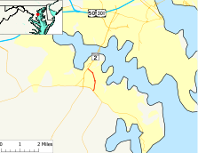
→Maryland Route 253 (MD 253) is a state highway in the U.S. state of Maryland. Known as Mayo Road, the route runs 1.34 mi (2.16 km) from Maryland Route 214 north to Maryland Route 2 within Edgewater.
Contents
Route description
Maryland Route 253 begins at an intersection with Maryland Route 214 (Central Avenue) across from the entrance to South River High School. The route heads north as a two-lane road with a speed limit of 30 mph (48 km/h) through a forested area. MD 253 then becomes lined with commercial establishments within dense residential development on the side streets, where it soon intersects Stepneys Lane and Londontown Road. Londontown Road leads to the historic London Town Publik House, located next to the landing of a former ferry across South River. After passing Washington Road, which leads to Edgewater Elementary School and South River Park, the road turns northwest and enters suburban commercial development immediately before it ends at an intersection with Maryland Route 2 (Solomons Island Road) across from the entrance to Lee Airport.
History
Maryland Route 253 originally extended along its current route, which was entirely paved by 1927, then east along current MD 214 to Mayo.[2] The 1939 Maryland state highway map shows MD 253 assigned to the above routing.[3] MD 253 was extended to Beverly Beach by 1946.[4] MD 214 was extended east to MD 253 in 1949 and replaced it east of the current southern terminus in 1950.[5][6]
Junction list
The entire route is in Edgewater, Anne Arundel County.
Mile[1] Destinations Notes 0.00  MD 214 (Central Avenue) – Davidsonville, Mayo
Southern terminus 0.50 Stepneys Lane / Londontown Road 1.07 Washington Road 1.34  MD 2 (Solomons Island Road) – Annapolis, Prince Frederick
Northern terminus References
- ^ a b Maryland State Highway Administration (2008). "Highway Location Reference: Anne Arundel County" (PDF). http://apps.roads.maryland.gov/KeepingCurrent/performTrafficStudies/dataAndStats/hwyLocationRef/2008_hlr_all/co02.pdf. Retrieved 2010-01-08.
- ^ Maryland State Highway Administration (1927). "Map of Maryland" (JPG). http://www.mdhighwaycentennial.com/images/template/gallery/maps/1927SIDE1.jpg. Retrieved 2010-01-07.
- ^ Maryland State Highway Administration (1939). "Map of Maryland" (PDF). http://commons.wikimedia.org/wiki/File:Maryland_State_Highway_Map_-_1939.pdf. Retrieved 2010-01-08.
- ^ Maryland State Highway Administration (1946). "Map of Maryland" (PDF). http://commons.wikimedia.org/wiki/File:Maryland_State_Highway_Map_-_1946.pdf. Retrieved 2010-01-08.
- ^ Maryland State Highway Administration (1949). "Map of Maryland" (PDF). http://commons.wikimedia.org/wiki/File:Maryland_State_Highway_Map_-_1949.pdf. Retrieved 2010-01-08.
- ^ Maryland State Highway Administration (1950). "Map of Maryland" (PDF). http://commons.wikimedia.org/wiki/File:Maryland_State_Highway_Map_-_1950.pdf. Retrieved 2010-01-08.
External links
Categories:- State highways in Maryland
- Roads in Anne Arundel County, Maryland
Wikimedia Foundation. 2010.

