- Maryland Route 270
-
This article describes a Maryland state highway numbered 270. For the Interstate with the same number, see Interstate 270.
Maryland Route 270 Furnace Branch Road 
Route information Maintained by MDSHA Length: 2.16 mi[1] (3.48 km) Major junctions South end:  MD 648 in Glen Burnie
 MD 10 in Glen Burnie
 MD 2 in Glen Burnie
North end: 
 MD 3 Bus. in Glen Burnie
Highway system Maryland highway system
Interstate • US • State • Minor • Former • Turnpikes←  I-270
I-270MD 272  →
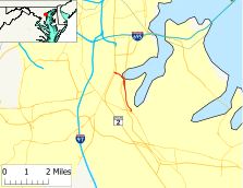
→Maryland Route 270 (MD 270) is a state highway in the U.S. state of Maryland. Known as Furnace Branch Road, the route runs 2.16 mi (3.48 km) from Maryland Route 648 north to Maryland Route 3 Business within Glen Burnie.
Contents
Route description
Maryland Route 270 begins at an intersection with Maryland Route 648 (Baltimore Annapolis Boulevard) immediately to the east of MD 648's (officially MD 648E) interchange with Maryland Route 10 (Arundel Expressway) and immediately to the west of Marley Creek. The road continues south of MD 648E as Maryland Route 648G, which is a connector to Maryland Route 648I (McGivney Way), which is an old alignment of MD 648 from before the construction of MD 10.
MD 270 heads northwest as a two-lane road with a speed limit of 40 mph (64 km/h) through a suburban area of businesses and residential subdivisions. Within the suburban area, the route reaches the intersection of Margate Drive and North Thompson Avenue, which crosses MD 10 to access residential areas on the other side of the expressway. After crossing Thompson Avenue, the road expands to a four-lane divided highway ahead of the signal-controlled intersection with Point Pleasant Road. The road then goes through a five-ramp interchange with MD 10.
After the interchange with MD 10, MD 270 becomes a five-lane road with center turn lane. After an intersection with Maryland Route 2 (Governor Ritchie Highway), MD 270 meets its northern terminus at a stop sign at Maryland Route 3 Business (Robert Crain Highway). Furnace Branch Road continues northwest as a county-maintained road about 1,200 ft (370 m) to the north of the intersection of MD 270 and MD 3 BUS.
History
Maryland Route 270 was entirely paved by 1933.[2] The 1939 Maryland state highway map shows MD 270 assigned to its present course.[3]
Junction list
The entire route is within Glen Burnie in Anne Arundel County.
Mile[1] Destinations Notes 0.00  MD 648 (Baltimore Annapolis Boulevard) – Glen Burnie, Pasadena
Southern terminus 1.05 North Thompson Road / Margate Drive 1.23 Point Pleasant Road 1.56  MD 10 (Arundel Expressway) – Baltimore, Severna Park
Follow MD 10 north to  I-695
I-6952.09  MD 2 (Governor Ritchie Highway) – Glen Burnie, Brooklyn Park
2.16 
 MD 3 BUS (Robert Crain Highway) - Glen Burnie
Northern terminus References
- ^ a b Maryland State Highway Administration (2008). "Highway Location Reference: Anne Arundel County" (PDF). http://apps.roads.maryland.gov/KeepingCurrent/performTrafficStudies/dataAndStats/hwyLocationRef/2008_hlr_all/co02.pdf. Retrieved 2010-01-12.
- ^ Maryland State Highway Administration (1933). "Map of Maryland" (PDF). http://commons.wikimedia.org/wiki/File:Maryland_State_Highway_Map_-_1933.pdf. Retrieved 2010-01-12.
- ^ Maryland State Highway Administration (1939). "Map of Maryland" (PDF). http://commons.wikimedia.org/wiki/File:Maryland_State_Highway_Map_-_1939.pdf. Retrieved 2010-01-12.
External links
Categories:- State highways in Maryland
- Roads in Anne Arundel County, Maryland
Wikimedia Foundation. 2010.

