- Maryland Route 100
-
Maryland Route 100
Paul T. Pitcher Memorial Highway 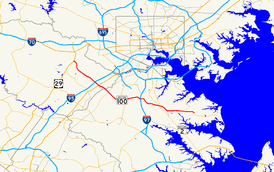
Route information Maintained by MDSHA Length: 22.05 mi[1][2] (35.49 km) Major junctions West end:  US 29 in Columbia
 MD 108
 MD 103
 I-95
I-95
 US 1
US 1
 MD 295
 MD 170
 I-97
I-97
 MD 2
MD 2 MD 10
MD 10East end:  MD 177 in Pasadena
Highway system Maryland highway system
Interstate • US • State • Minor • Former • Turnpikes←  MD 99
MD 99MD 103 →Maryland Route 100 (MD 100 or Route 100) is a major east–west highway connecting U.S. Route 29 (US 29) in Ellicott City (just north of Columbia) and MD 177 (Mountain Road) in Pasadena. MD 100 also connects to Interstate 95 (I-95), US 1, the Baltimore-Washington Parkway (MD 295), and I-97. The highway connects Howard County to the west with Anne Arundel County and the Chesapeake Bay to the east. MD 100 also provides access to the Baltimore-Washington International Airport (BWI) and the Arundel Mills shopping mall.
The eastern section of MD 100 in Anne Arundel County is known as the Paul T. Pitcher Memorial Highway. The name comes in dedication to Paul T. Pitcher, an Anne Arundel County executive, who originally conceived the highway.[3]
Contents
Route description
The route begins as a four-lane divided expressway at MD 177, continuing west and intersecting MD 607 near Jacobsville. Beyond this intersection, MD 100 upgrades into a four-lane freeway and forms a bypass of MD 177. At MD 10, the highways split, with each road merging with its counterpart from MD 10, forming a weave zone where traffic for each route must weave on the flat to stay on the same route.
Beyond this unusual interchange, MD 100 interchanges with MD 2 and follows one of the oldest segments of the highway as far as Interstate 97. Beyond here, the route increases from four to six lanes and interchanges with MD 170 (Telegraph Road), where the route narrows to four lanes again. It also interchanges with MD 713 (Arundel Mills Boulevard), the Baltimore-Washington Parkway, the Dorsey MARC station at Exit 7, and US 1 before reaching Interstate 95. The segment between and I-95 is another one of the oldest segments of the highway.
Beyond I-95, the route increases to, and remains from there on, six lanes through interchanges with MD 103, Snowden River Parkway, MD 104 and MD 108 before finally terminating at US 29 near Ellicott City.
History
Maryland Route 100 began in the 1970s as two separate roads, both having the MD 100 designation. The first was known as the Mountain Road Extension, stretching between Governor Ritchie Highway and the old Maryland Route 3, now Interstate 97. The second was built as a short spur between the newly constructed Interstate 95 and US 1 in Elkridge, Maryland. The eastern section, originally known as the Mountain Road Bypass, was constructed east of Ritchie Highway in the late 1970s. MD 100 was completed west of I-97 to I-95, thereby connecting the two roads, in 1994, but it was not completed in its entirety to US 29 until November 1998. A portion of the route between Exit 1B-C and Exit 2 was constructed earlier than the rest as an at-grade boulevard, on the right-of-way of the future eastbound lanes; this section was eventually upgraded. [4]
The construction of the route near Lake Waterford Road severed the original road between Baltimore and Annapolis: the Baltimore-Annapolis Boulevard, signed in part as MD 648. The physical road ends at a pair of dead ends on either side of the right-of-way; MD 648 follows Lake Waterford Road between Baltimore-Annapolis Boulevard and MD 177 before rejoining its original path.
The route is part of the Baltimore Outer Beltway, a 3/4 circular beltway designed to provide a route parallel to the Baltimore Beltway. MD 100 represents the major portion that was built; US 29 between MD 100's terminus and US 29's own northern terminus at Maryland Route 99, four miles (6 km) in length, is another portion. The Outer Beltway was projected beyond MD 99 to run through Howard and Baltimore Counties and intersect MD 140, Interstate 83, US 1, and Interstate 95 before terminating at US 40 northeast of Baltimore.
Junction list
County Location Mile Exit Destinations Notes Howard Ellicott City 0.0  US 29 to I-70 – Columbia, Ellicott City
0.7 1A Long Gate Parkway to MD 103no westbound exit 1.4 1B Centre Park Drive no eastbound exit; westbound entrance/exit signed as 1B-C 1C Executive Park Drive to MD 108eastbound entrance and eastbound exit 2.5 2  MD 104 / MD 108
Columbia 3 Snowden River Parkway – Columbia 4 MD 103 (Meadowridge Road)Elkridge 5.4 5 I-95 – Baltimore, Washington, D.C.split into 5A and 5B 6.1 6 US 1 (Washington Boulevard) – Elkridge, Waterloosplit into 6A and 6B on eastbound side only 6.8 7  Dorsey MARC Station
No trucks over five tons. Anne Arundel Dorsey 7.4 8 Coca-Cola Drive to MD 1038.1 9 MD 295 (Baltimore-Washington Parkway) – Baltimore, Fort Meadesplit into 9A and 9B Hanover 9.1 10  MD 713 (Arundel Mills Boulevard) – Hanover, Arundel Mills
split into 10A and 10B 11.1 11 MD 170 (Telegraph Road) – Odenton, Linthicum13.6 13 
 I-97 to MD 3 / MD 32 – Baltimore, Annapolis
split into 13A and 13B. To Baltimore via I-695 and I-895 Glen Burnie 14.2 14  MD 174 (Quarterfield Road)
eastbound exit and westbound entrance 15.6 15 Oakwood Road 16.8 16 MD 2 – Glen Burnie, Pasadenasplit into 16A and 16B; 16B on westbound provides access via MD 177 17.4 17  MD 10 north to I-695 – Glen Burnie
westbound exit and eastbound entrance 18.3 18 MD 10 south to MD 2 – Severna Parkeastbound exit and westbound entrance 19.8 19 Catherine Avenue eastbound exit and westbound entrance 20.6 20  Edwin Raynor Boulevard to MD 173 (Fort Smallwood Road)
eastbound exit and westbound entrance; MD 100 becomes four-lane at-grade expressway Jacobsville 21.2  MD 607 (Magothy Bridge Road) to MD 177
Magothy Beach Road 22.1 MD 177 (Mountain Road) – Lake Shore, Gibson Islandeastbound exit and westbound entrance; eastern terminus of MD 100 Notes
- The cloverleaf ramp allowing access to MD 2 north from MD 100 east is an accident hotspot, with many drivers neglecting to slow down before entering the ramp and colliding with the earthworks beyond the ramp curb. The roadway was realigned and resurfaced in 2006 in an attempt to reduce the number of accidents.
Related routes
References
- ^ Maryland State Highway Administration (2008). "Highway Location Reference: Howard County" (PDF). http://apps.roads.maryland.gov/KeepingCurrent/performTrafficStudies/dataAndStats/hwyLocationRef/2008_hlr_all/co13.pdf. Retrieved 2010-04-21.
- ^ Maryland State Highway Administration (2008). "Highway Location Reference: Anne Arundel County" (PDF). http://apps.roads.maryland.gov/KeepingCurrent/performTrafficStudies/dataAndStats/hwyLocationRef/2008_hlr_all/co02.pdf. Retrieved 2010-04-21.
- ^ http://www.mdasphalt.org/paver99/1999Paverspring.pdf
- ^ [1]
External links
Categories:- State highways in Maryland
- Roads in Howard County, Maryland
- Roads in Anne Arundel County, Maryland
- Freeways in the United States


Wikimedia Foundation. 2010.