- Maryland Route 156
-
Maryland Route 156
Aldino Road 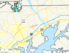
Route information Maintained by MDSHA Length: 3.92 mi[1] (6.31 km) Major junctions West end:  MD 22 in Churchville
East end:  MD 155 near Webster
Location Counties: Harford Highway system Maryland highway system
Interstate • US • State • Minor • Former • Turnpikes← MD 155MD 157  →
→Maryland Route 156 (MD 156) is a state highway in the U.S. state of Maryland. Known as Aldino Road, the state highway runs 3.92 miles (6.31 km) from MD 22 in Churchville east to MD 155 near Webster. MD 156 provides access to the Harford County Airport in the unincorporated community of Aldino. The state highway, which was originally designated part of MD 155, was built as a modern highway by 1910 and rebuilt in the 1920s. MD 156 received its present designation in 1952 when MD 155 and MD 156 swapped paths.
Contents
Route description
MD 156 begins at an oblique intersection with MD 22 (Churchville Road) in Churchville. Access is only permitted from westbound MD 156 to westbound MD 22 and from eastbound MD 22 to eastbound MD 156. The movements to connect with MD 22 in the direction of Aberdeen are made via the Aldino Road Spur, which is unsigned MD 156A. MD 156 heads east as a two-lane road through farmland. The state highway provides access to the Harford County Airport in the hamlet of Aldino and intersects Chapel Road, which heads toward Havre de Grace and passes the historic homes Chestnut Ridge and Winsted. MD 156 crosses Swan Creek before it reaches its eastern terminus at MD 155 (Level Road) near Webster.[1][2]
History
MD 156 follows the path of the old Bel Air Road from Havre de Grace. As a result, the highway was already paved by 1910.[3] The state highway was repaved in macadam starting from the west end in 1921 and completed east to Webster in 1922.[4][5][6] Aldino Road was originally marked as part of MD 155, which ran from the MD 22–MD 156 intersection in Churchville east to Havre de Grace; Level Road from Churchville to Hopewell Village was designated MD 156.[7] MD 155 and MD 156 swapped routes in 1952.[8]
Junction list
The entire route is in Harford County.
Location Mile[1] Destinations Notes Churchville 0.00 MD 22 west (Churchville Road) – Bel AirWestern terminus 0.07 To MD 22 east (Churchville Road) – AberdeenUnsigned MD 156A Webster 3.92 MD 155 (Level Road) – Havre de Grace, Hopewell VillageEastern terminus 1.000 mi = 1.609 km; 1.000 km = 0.621 mi Auxiliary route
MD 156A is the designation for the Aldino Road Spur, a 0.04-mile (0.064 km) connector between MD 22 and MD 156 in Churchville. The spur completes the adjacent partial intersection of MD 22 and MD 156 by allowing access from westbound MD 22 to eastbound MD 156 and from westbound MD 156 to eastbound MD 156. MD 156A was designated in 2009.[1][9] However, the Aldino Road Spur dates back to at least 1999.[10]
References
- ^ a b c d "Highway Location Reference: Harford County" (PDF). Maryland State Highway Administration. 2009. http://www.marylandroads.com/Location/2009_HARFORD.pdf. Retrieved 2011-03-03.
- ^ Google, Inc. Google Maps – Maryland Route 156 (Map). Cartography by Google, Inc. http://maps.google.com/maps?f=d&source=s_d&saddr=MD-156%2FAldino+Rd&daddr=MD-156%2FAldino+Rd+to:MD-156%2FAldino+Rd&hl=en&geocode=FTCNWwIdiLF0-w%3BFbyxWwIdCxh1-w%3BFVDTWwId-ad1-w&mra=ls&sll=39.555743,-76.234581&sspn=0.007478,0.01929&ie=UTF8&t=h&z=14. Retrieved 2011-03-03.
- ^ Maryland Geological Survey. Map of Maryland (Map) (1910 ed.).
- ^ Maryland Geological Survey. Map of Maryland: Showing State Road System and State Aid Roads (Map) (1921 ed.).
- ^ Maryland Geological Survey. Map of Maryland: Showing State Road System and State Aid Roads (Map) (1923 ed.).
- ^ "NBI Structure Number: 100000120038030". National Bridge Inventory. http://nationalbridges.com/nbi_record.php?StateCode=24&struct=100000120038030. Retrieved 2011-03-03.
- ^ Maryland State Roads Commission. General Highway Map: State of Maryland (Map) (1939 ed.).
- ^ Maryland State Roads Commission. Maryland: Official Highway Map (Map) (1952 ed.).
- ^ Google, Inc. Google Maps – Maryland Route 156A (Map). Cartography by Google, Inc. http://maps.google.com/maps?f=d&source=s_d&saddr=Unknown+road&daddr=Unknown+road&hl=en&geocode=FcKKWwId5rN0-w%3BFfaLWwIdp7V0-w&mra=ls&sll=39.553361,-76.235268&sspn=0.003739,0.009645&ie=UTF8&ll=39.553791,-76.237006&spn=0.00187,0.004823&t=h&z=18. Retrieved 2011-03-03.
- ^ "Highway Location Reference: Harford County" (PDF). Maryland State Highway Administration. 1999. http://www.marylandroads.com/Location/1999_HARFORD.pdf. Retrieved 2011-03-03.
External links
Roads in Harford County, Maryland State highways 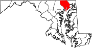
U.S. Highways Interstate Highways Categories:- State highways in Maryland
- Roads in Harford County, Maryland


Wikimedia Foundation. 2010.