- Maryland Route 132
-
Maryland Route 132

Route information Maintained by MDSHA MD 132 Length: 2.15 mi[1] (3.46 km) West end: Cul-de-sac in Aberdeen Major
junctions: US 40 in Aberdeen
East end: Norman Avenue in Aberdeen MD 132B Length: 1.43 mi[1] (2.30 km) South end:  MD 22 in Aberdeen
North end: US 40 near Havre de GraceLocation Counties: Harford Highway system Maryland highway system
Interstate • US • State • Minor • Former • Turnpikes←  MD 131
MD 133  →
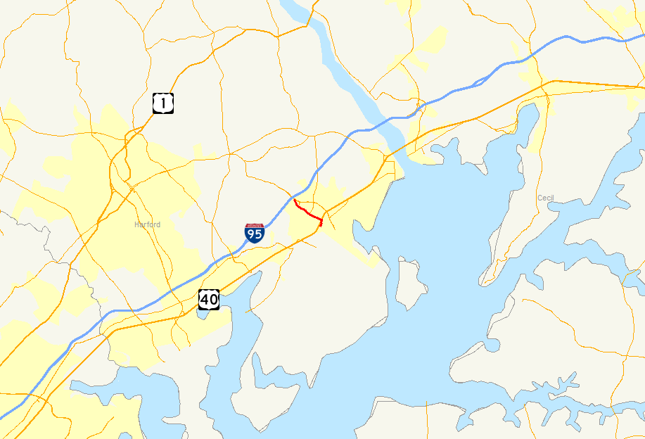
→Maryland Route 132 (MD 132) is a collection of state highways in the U.S. state of Maryland. These four highways are sections of old alignment of and connecting roads with MD 22 in Aberdeen. MD 132 is an east–west highway within Aberdeen that connects neighborhoods east and west of U.S. Route 40 (US 40) with MD 22 and Interstate 95 (I-95). MD 132B is a north–south highway that serves the area east of US 40 and north of MD 22 between Aberdeen and Havre de Grace. MD 132A and MD 132C are connectors between MD 132 and MD 22. The highways that are now part of MD 132 were originally built in the early 1910s and marked as part of MD 22 and US 40 in 1927. MD 22 was extended east and north along the US 40 portion when the U.S. highway was relocated in the 1930s. MD 132 was assigned to the highway when MD 22 was relocated in the late 1960s. MD 132 became a split route following the construction of a railroad grade separation in the 1980s.
Contents
Route description
MD 132 runs 2.15 miles (3.46 km) between the west and east sides of Aberdeen. MD 132B runs 1.43 miles (2.30 km) from MD 22 in Aberdeen north to US 40 near Havre de Grace.[1]
MD 132
MD 132 begins at a cul-de-sac adjacent to I-95's interchange with MD 22 just west of the city limits of Aberdeen. The highway immediately receives a ramp from northbound I-95. MD 132 heads east as two-lane Bel Air Avenue through a commercial area and intersects Northeast Road; the north leg of the intersection is a one-lane ramp from eastbound MD 22 that is unsigned MD 132C. MD 132's next intersection is with Bush Chapel Road and Beards Hill Road. Beards Hill Road, which is unsigned MD 132A, provides access to MD 22 (Aberdeen Thruway) and that highway's interchange with I-95 a short distance to the west. MD 132 continues east through residential neighborhoods of Aberdeen, where the highway meets the southern end of MD 462 (Paradise Road) and passes the historic James B. Baker House.[1][2]
MD 132 crosses CSX's Philadelphia Subdivision at grade and enters downtown Aberdeen, where the highway intersects US 40 (Philadelphia Boulevard). Adjacent to the intersection is the Aberdeen Amtrak station, which is also a stop on MARC's Penn Line. Immediately east of US 40, MD 132 makes a right angle turn south and crosses over the Amtrak Northeast Corridor on an S-curve. The state highway reaches its eastern terminus just south of the end of the bridge at its intersection with Norman Avenue and federal government-maintained APG Road in a residential neighborhood. Both streets connect with Post Road, which heads north as a municipal street toward MD 132B.[1][2]
MD 132B
MD 132B begins at an intersection with MD 22 (Aberdeen Thruway) on the east side of Aberdeen. The state highway heads northeast as Post Road, a two-lane highway that passes between residential subdivisions and distribution centers. MD 132 leaves the city of Aberdeen and crosses Swan Creek before curving northwest and meeting Oakington Road on a tangent. Oakington Road leads to the Oakington community, which contained the farm of former U.S. Senator Millard E. Tydings. MD 132B's name changes to Oakington Road for the highway's final stretch, a crossing of the Amtrak Northeast Corridor immediately to the south of the highway's terminus at US 40 (Pulaski Highway).[1][3]
History
MD 132 and MD 132B are the old alignment of MD 22 in the Aberdeen area. MD 132 west of Paradise Road and MD 132B north of its southern terminus were constructed as macadam roads around 1911.[4] Bel Air Avenue east of Paradise Road and Post Road south to Bel Air Avenue east of downtown Aberdeen were constructed as a concrete road in 1917.[5] When the Maryland State Roads Commission first assigned route numbers in 1927, Bel Air Avenue was designated MD 22 and Post Road became part of US 40.[6] US 40 was moved to its present alignment between Aberdeen and Havre de Grace between 1930 and 1933; Post Road was renumbered as an extension of MD 22 by 1939.[7][8][9]
In 1969, MD 22 was transferred to the newly-completed Aberdeen Thruway. MD 132 was assigned to MD 22's old alignment east of the I-95 interchange at that time.[10] Beards Hill Road was reconstructed as a divided highway between MD 132 and MD 22 and the ramps from northbound I-95 to MD 132 and from eastbound MD 22 to MD 132 were constructed by 1972.[11] MD 132's S-curve bridge over the Amtrak Northeast Corridor was completed in 1983, replacing Bel Air Avenue's at-grade crossing of the railroad.[12] Bel Air Avenue east of the Amtrak line and Post Road south of MD 22 were removed from the state highway system around 1989.[13]
Junction list
MD 132
The entire route is in Aberdeen in Harford County.
Mile
[1]Destinations Notes 0.00 Cul-de-sac Western terminus; highway receives a ramp from northbound I-95 0.15 Northeast Road west North leg of intersection is one-lane, unsigned MD 135C 0.42 Beards Hill Road north to  MD 22 to I-95 / Bush Chapel Road south
Beards Hill Road is unsigned MD 132A 1.16  MD 462 north (Paradise Road)
1.82 US 40 (Philadelphia Boulevard) – Havre de Grace, Edgewood2.15 Norman Avenue east / APG Road east Eastern terminus 1.000 mi = 1.609 km; 1.000 km = 0.621 mi MD 132B
The entire route is in Harford County.
Location Mile
[1]Destinations Notes Aberdeen 0.00 MD 22 (Aberdeen Thruway) – Aberdeen Proving Ground, Bel AirSouthern terminus Havre de Grace 1.43 US 40 (Pulaski Highway) – Aberdeen, PerryvilleNorthern terminus 1.000 mi = 1.609 km; 1.000 km = 0.621 mi Auxiliary routes
- MD 132A is the designation for a 0.24-mile (0.39 km) section of Beards Hill Road that connects MD 132 with MD 22.[1][14] MD 132A was reconstructed as a four-lane divided highway and brought into the state highway system by 1972.[11]
- MD 132C is the designation for an unnamed one-lane 0.14-mile (0.23 km) ramp from eastbound MD 22 to MD 132 just east of MD 132's western terminus.[1][15] The ramp has existed since at least 1972; however, it was not designated MD 132C until 2007.[11][16]
References
- ^ a b c d e f g h i j "Highway Location Reference: Harford County" (PDF). Maryland State Highway Administration. 2009. http://www.marylandroads.com/Location/2009_HARFORD.pdf. Retrieved 2011-02-28.
- ^ a b Google, Inc. Google Maps – Maryland Route 132 (Map). Cartography by Google, Inc. http://maps.google.com/maps?f=d&source=s_d&saddr=W+Bel+Air+Ave&daddr=Aberdeen+Blvd&hl=en&geocode=FdgXWwId0W91-w%3BFXDMWgIdetJ1-w&mra=ls&sll=39.523128,-76.188855&sspn=0.003741,0.009645&ie=UTF8&t=h&z=14. Retrieved 2011-02-28.
- ^ Google, Inc. Google Maps – Maryland Route 132B (Map). Cartography by Google, Inc. http://maps.google.com/maps?f=d&source=s_d&saddr=N+Post+Rd&daddr=N+Post+Rd+to:Oakington+Rd&hl=en&geocode=FSLiWgIdbvV1-w%3BFeLyWgIdsg52-w%3BFTEYWwIdbDl2-w&mra=ps&sll=39.514421,-76.151047&sspn=0.003741,0.009645&ie=UTF8&ll=39.517549,-76.134825&spn=0.029928,0.077162&t=h&z=14. Retrieved 2011-02-28.
- ^ Report of the State Roads Commission of Maryland. 1912-1915. Baltimore: Maryland State Roads Commission. May 1915. pp. 112, 124. http://www.archive.org/details/annualreportsofs1912mary. Retrieved 2011-02-28.
- ^ Report of the State Roads Commission of Maryland. 1916-1919. Baltimore: Maryland State Roads Commission. January 1920. p. 39. http://www.archive.org/details/annualreportsofs1916mary. Retrieved 2011-02-28.
- ^ Maryland Geological Survey. Map of Maryland: Showing State Road System and State Aid Roads (Map) (1927 ed.).
- ^ Report of the State Roads Commission of Maryland. 1927-1930. Baltimore: Maryland State Roads Commission. 1930-10-01. p. 68. http://www.archive.org/details/reportofstateroa1927mary. Retrieved 2011-02-28.
- ^ Maryland Geological Survey. Map of Maryland Showing State Road System: State Aid Roads and Improved County Road Connections (Map) (1933 ed.).
- ^ Maryland State Roads Commission. General Highway Map: State of Maryland (Map) (1939 ed.).
- ^ Maryland State Roads Commission. Maryland: Official Highway Map (Map) (1969 ed.).
- ^ a b c Maryland State Highway Administration. Maryland: Official Highway Map (Map) (1972 ed.).
- ^ Maryland State Highway Administration. Maryland: Official Highway Map (Map) (1983-84 ed.).
- ^ Maryland State Highway Administration. Maryland: Official Highway Map (Map) (1989 ed.).
- ^ Google, Inc. Google Maps – Maryland Route 132A (Map). Cartography by Google, Inc. http://maps.google.com/maps?f=d&source=s_d&saddr=Beards+Hill+Rd&daddr=Beards+Hill+Rd&hl=en&geocode=FeQEWwIdOH91-w%3BFfARWwIdFIV1-w&mra=ls&sll=39.520694,-76.185089&sspn=0.003741,0.009645&ie=UTF8&ll=39.521241,-76.183062&spn=0.007482,0.01929&t=h&z=16. Retrieved 2011-02-28.
- ^ Google, Inc. Google Maps – Maryland Route 132C (Map). Cartography by Google, Inc. http://maps.google.com/maps?f=d&source=s_d&saddr=NE+Rd&daddr=NE+Rd&hl=en&geocode=FTwWWwIdvHh1-w%3BFfYQWwIdmHR1-w&mra=ls&sll=39.523417,-76.18724&sspn=0.00187,0.004823&ie=UTF8&ll=39.523483,-76.189016&spn=0.003741,0.009645&t=h&z=17. Retrieved 2011-02-28.
- ^ "Highway Location Reference: Harford County" (PDF). Maryland State Highway Administration. 2007. http://www.marylandroads.com/Location/2007_HARFORD.pdf. Retrieved 2011-02-28.
External links
Roads in Harford County, Maryland State highways 
U.S. Highways Interstate Highways Categories:- State highways in Maryland
- Roads in Harford County, Maryland


Wikimedia Foundation. 2010.