- Maryland Route 462
-
Maryland Route 462
Paradise Road 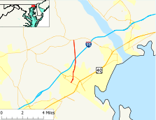
Route information Maintained by MDSHA Length: 4.15 mi[1] (6.68 km) Major junctions South end:  MD 132 in Aberdeen
 MD 22 in Aberdeen
North end:  MD 155 in Webster
Location Counties: Harford County Highway system Maryland highway system
Interstate • US • State • Minor • Former • Turnpikes←  MD 461
MD 463  →
→Maryland Route 462 (MD 462) is a state highway in the U.S. state of Maryland. Known as Paradise Road, the route runs 4.15 miles (6.68 km) from MD 132 in Aberdeen north to MD 155 in Webster. MD 462 was built in the early 1930s.
Contents
Route description
MD 462 begins at an intersection with MD 132 (Bel Air Avenue) in the city of Aberdeen. The state highway heads north as a two-lane road through a residential neighborhood. Shortly after passing Aberdeen High School, MD 462 intersects MD 22 (Aberdeen Thruway), which connects Aberdeen Proving Ground with Interstate 95 (I-95) and Bel Air. The state highway continues north through residential areas and leaves the city limits of Aberdeen between crossings of Carsins Run and Swan Creek. MD 462 passes through a mix of farmland and forest and passes under I-95 with no access. The state highway has staggered intersections with Chapel Road, which heads east toward Havre de Grace and west toward Aldino. MD 462 intersects Webster Road, the old alignment of MD 155, before reaching its northern terminus at MD 155 (Level Road) in the village of Webster.[1][2]
History
MD 462 was fully paved in macadam from Aberdeen to Webster by 1933.[3] The state highway has not changed since except for minor improvements.
Junction list
The entire route is in Harford County.
Location Mile[1] Destinations Notes Aberdeen 0.00 MD 132 (Bel Air Avenue)Southern terminus 0.65 MD 22 (Aberdeen Thruway) – Bel Air, Aberdeen Proving GroundWebster 4.15 MD 155 (Level Road) – Churchville, Havre de GraceNorthern terminus 1.000 mi = 1.609 km; 1.000 km = 0.621 mi References
- ^ a b c "Highway Location Reference: Harford County" (PDF). Maryland State Highway Administration. 2009. http://www.marylandroads.com/Location/2009_HARFORD.pdf. Retrieved 2011-03-01.
- ^ Google, Inc. Google Maps – Maryland Route 462 (Map). Cartography by Google, Inc. http://maps.google.com/maps?f=d&source=s_d&saddr=Paradise+Rd&daddr=MD-462+N%2FParadise+Rd&hl=en&geocode=FWrtWgId9Kl1-w%3BFcTTWwIdjr91-w&mra=ls&sll=39.512418,-76.171432&sspn=0.014965,0.038581&ie=UTF8&ll=39.539264,-76.216965&spn=0.119674,0.308647&t=h&z=12. Retrieved 2011-03-02.
- ^ Maryland Geological Survey. Map of Maryland Showing State Road System: State Aid Roads and Improved County Road Connections (Map) (1933 ed.).
External links
Roads in Harford County, Maryland State highways 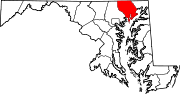
U.S. Highways Interstate Highways Categories:- State highways in Maryland
- Roads in Harford County, Maryland


Wikimedia Foundation. 2010.