- Maryland Route 129
-
Maryland Route 129
Park Heights Avenue 
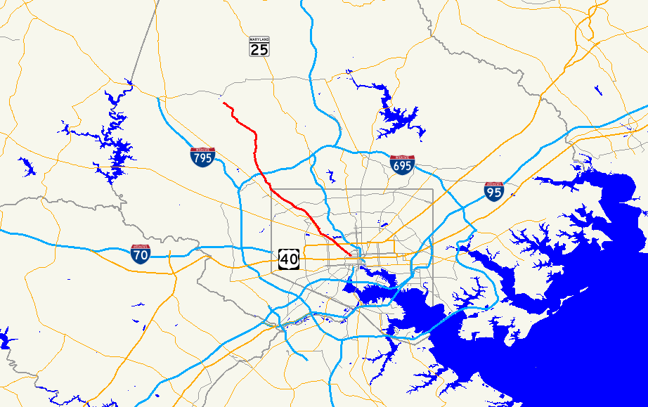
Route information Maintained by MDSHA, Baltimore DOT Length: 15.43 mi[1][2] (24.83 km) Major junctions South end: 
 US 40/MD 295 in downtown Baltimore
 MD 140 near Mondawmin
 I-695 near Pikesville
North end: Garrison Forest Rd. near Reisterstown Highway system Maryland highway system
Interstate • US • State • Minor • Former • Turnpikes←  MD 128
MD 130  →
→Maryland Route 129 is a state highway in the U.S. state of Maryland, running north-northwesterly from downtown Baltimore into Baltimore County, ending east of Reisterstown. The route leaves downtown on the one-way pair of McCulloh Street and Druid Hill Avenue, and then uses the entire length of Park Heights Avenue to the end.
Contents
Route description
Baltimore City
Maryland Route 129, in Baltimore City, passes through or near many historic neighborhoods. These include Upton, Bolton Hill, Reservoir Hill, Pimlico, and Park Heights. The route is mostly lined with rowhouses until it reaches Upper Park Heights, an area known for its single-family homes, duplexes, and luxury apartments and condos. (Fallstaff, Baltimore)
Park Heights Avenue is also one of the boundaries of the famous Pimlico Race Course, home of the Preakness Stakes.
The entire route throughout Baltimore City has at least two travel lanes in each direction and parallel parking in most locations. For a short distance while passing Druid Hill Park, route 129 overlaps with Maryland Route 140, also known as Reisterstown Road.
Baltimore County
When Maryland Route 129 reaches the city/county line after Seven Mile Lane then at Slade Avenue, the road narrows into one travel lane in each direction, plus occasional turn lanes. From this point until its terminus at Garrison Forest Road in Owings Mills, the road is lined with upscale communities and undeveloped land.
The route intersects with the Interstate 695, also known as the Baltimore Beltway, about one mile (1.6 km) north of the city line.
Major landmarks
The following well-known landmarks can be found along Maryland Route 129:
- Druid Hill Park and the Maryland Zoo
- Pimlico Race Track
- Baltimore Hebrew University
- Suburban Country Club
- Druid Ridge Cemetery
- "Synagogue Row": A number of synagogues and a Jewish Community Center are clustered near each other near the start of Route 129. These include:
- Temple Oheb Shalom, in a building designed by Walter Gropius
Streets near Pimlico Race Course
- Glen Avenue
- Cross Country Boulevard
- Pimlico Road and Greenspring Avenue
Public transportation
In Baltimore City, there is plenty of public transportation along Maryland Route 129. Along Druid Hill Avenue/McCulloh Street, bus service is provided by Route 5. Route 54 operates along Park Heights Avenue up to Slade Avenue. Route 58 also overlaps with Route 54 between Glen Avenue and Clarks Lane, and Route 97 (Mondawmin Shuttle Bug) also operates in a southbound direction only between Coldspring Lane and Park Circle.
Following the elimination of Route M-12 in October 2005, there was no public transportation on any part of Maryland Route 129 in Baltimore County until the introduction of Route 18 in 2010.
Junction list
County Location Mile[1][2] Intersection Notes Baltimore City
(7.44 mi)0.00 US 40 (Franklin Street); MD 295 south (Paca Street; Greene Street)US 40 east (Mulberry Street) is one block south on MD 295. 0.32 Martin Luther King Jr. Boulevard 1.40 

 US 1/US 40 Truck (North Avenue)
2.44 Liberty Heights Avenue (to MD 26 west); Greenspring Avenue 2.72 MD 140 south (Reisterstown Road)MD 140 overlap begins 2.93 MD 140 north (Reisterstown Road)MD 140 overlap ends 5.44 Northern Parkway Baltimore
(7.99 mi)8.11  MD 133 east (Old Court Road)
8.81  MD 129A east (Brooks Robinson Drive) to I-695 inner
8.85 I-695 outerExit 21 of I-695 10.42 MD 130 (Greenspring Valley Road)15.43 Garrison Forest Road References
- ^ a b Maryland State Highway Administration (2005). "Highway Location Reference: Baltimore City" (PDF). http://apps.roads.maryland.gov/KeepingCurrent/performTrafficStudies/dataAndStats/hwyLocationRef/2005_hlr_all/co24.pdf. Retrieved 2009-12-10.
- ^ a b Maryland State Highway Administration (2008). "Highway Location Reference: Baltimore County" (PDF). http://apps.roads.maryland.gov/KeepingCurrent/performTrafficStudies/dataAndStats/hwyLocationRef/2008_hlr_all/co03.pdf. Retrieved 2010-04-21.
Annapolis Road · Aliceanna Street · Artmuseum Drive · Baltimore Street · Bellona Avenue · Biddle Street · Boston Street · Broadway · Broening Highway · Calvert Street · Cathedral Street · Caton Avenue · Centre Street · Charles Street · Chase Street · Coldspring Lane-Moravia Road · Druid Hill Avenue · Eager Street · Eastern Avenue · Eutaw Street · Falls Road · Fayette Street · Fleet Street · Franklin Street · Gay Street · Greene Street · Greenmount Avenue · Greene Street · Greenspring Avenue · Guilford Avenue · Gwynns Falls Parkway · Greenmount Avenue · Hanover Street · Harford Road · Hilton Street/Hilton Parkway · Howard Street · Key Highway · Liberty Heights Avenue · Loch Raven Boulevard · Lexington Street · Lombard Street · Madison Street · Maryland Avenue · McCulloh Street · Monument Street · Mt. Royal Avenue · Mulberry Street · North Avenue · Northern Parkway · Paca Street · Park Heights Avenue · Paca Street · Park Avenue · Patapsco Avenue · Pennsylvania Avenue · Pratt Street · Preston Street · Reisterstown Road · Roland Avenue · Russell Street · St. Paul Street · Saratoga Street · The Alameda · University Parkway · Wabash Avenue · York Road
Categories:- State highways in Maryland
- Roads in Baltimore County, Maryland
- Roads in Baltimore, Maryland

Wikimedia Foundation. 2010.