- Maryland Route 155
-
Maryland Route 155
Route information Maintained by MDSHA Length: 9.06 mi[1] (14.58 km) Major junctions West end:  MD 22 in Churchville
 MD 161 in Hopewell Village
 MD 156 near Webster
 MD 462 in Webster
 I-95 near Havre de Grace
East end: 
 US 40 / MD 7 in Havre de Grace
Location Counties: Harford Highway system Maryland highway system
Interstate • US • State • Minor • Former • Turnpikes←  MD 154
MD 156 →Maryland Route 155 (MD 155) is a state highway in the U.S. state of Maryland. Known for most of its length as Level Road, the state highway runs 9.06 miles (14.58 km) from MD 22 in Churchville east to U.S. Route 40 (US 40) and MD 7 in Havre de Grace. In conjunction with MD 22, MD 155 serves as the main highway linking Bel Air and Havre de Grace in eastern Harford County. The state highway also connects Havre de Grace with Interstate 95 (I-95) and Susquehanna State Park. The first portion of MD 155 near Havre de Grace was built by 1910; the remainder of the highway east of Hopewell Village was completed in the mid 1920s. The Churchville–Hopewell Village portion of the state highway, originally designated MD 156, was built in the mid 1930s. MD 155 received its present designation over its western half in 1952 when MD 155 and MD 156 swapped paths.
Contents
Route description
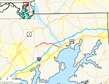
MD 155 begins at an intersection with MD 22 (Churchville Road) in Churchville. The state highway heads east as Level Road, a two-lane road that passes by Church of the Holy Trinity and Churchville County Park and intersects Glenville Road, which heads northeast through the Finney Houses Historic District. In Hopewell Village (also known as Level), MD 155 becomes a partially controlled access highway east to I-95. The state highway parallels two sections of old alignment, McCommons Road to the south and Level Village Road to the north, and meets the southern end of MD 161 (Darlington Road) at a three-way stop. East of the village, MD 155 is paralleled by Rider Lane to the south and intersects the east end of MD 156 (Aldino Road). In the village of Webster, the state highway meets the northern terminus of MD 462 (Paradise Road), Webster Road parallels the highway to the south, and the highway intersects Webster Lapidum Road, which heads northeast toward the Steppingstone Museum and the ruins of Lapidum, which are both contained within Susquehanna State Park.[1][2]
After meeting I-95 (John F. Kennedy Memorial Highway) at a diamond interchange, MD 155 passes the historic home Sion Hill and passes a truck check station that heralds the steep descent from the bluff above the Susquehanna River to the city of Havre de Grace. During the descent, the state highway has four lanes: one lane eastbound, a center turn lane, and two lanes westbound. The center turn lane disappears and a second lane appears eastbound as MD 155 enters the city limits, where its name changes to Superior Street. Close to the bottom of the hill, the state highway passes under CSX's Philadelphia Subdivision and turns south onto Ohio Street. Superior Street continues straight as MD 763 toward downtown Havre de Grace. MD 155 heads south as a two-lane street for a short distance before reaching its eastern terminus at an intersection with US 40 (Pulaski Highway) and MD 7 (Otsego Street). At this five-way intersection, MD 155 and MD 7 are perpendicular and US 40 cuts across from southwest to northeast, requiring a very sharp left turn to access eastbound US 40 to cross the Thomas J. Hatem Memorial Bridge to Perryville.[1][2]
History
MD 155 from Webster east follows the path of the old Bel Air Road from Havre de Grace. As a result, the highway was paved from the city limits of Havre de Grace west to Lapidum Road by 1910.[3] MD 155 was paved with macadam from Aldino Road to Earlton Road in 1923, which was an extension of construction along Aldino Road.[4] The gap between Earlton Road and Lapidum Road was filled by 1927.[5] MD 155 was originally assigned to Aldino Road east from Churchville, then its modern path to Havre de Grace.[6] The next segment of MD 155's modern path to be constructed was from Aldino Road to Hopewell Village, which was paved in macadam in 1928 as part of MD 161.[7] The original MD 156, Level Road from Churchville to Hopewell Village, was started east from Churchville around 1933.[8] Construction on the state highway resumed by 1936 and was completed by 1938.[9][10] MD 155 and MD 156 swapped routes in 1952.[11] In 1954, the intersection of MD 22 and MD 155 was reconstructed.[12] The MD 22–MD 155 intersection was relocated to the east to increase the distance from the intersection of MD 22 and MD 136 in 2003.[13]
Junction list
The entire route is in Harford County.
Location Mile[1] Destinations Notes Churchville 0.00 MD 22 (Churchville Road) – Bel Air, AberdeenWestern terminus Hopewell Village 3.72 MD 161 north (Darlington Road) – DarlingtonWebster 4.42 MD 156 west (Aldino Road) – Churchville4.74 MD 462 south (Paradise Road) – AberdeenHavre de Grace 6.51 I-95 (John F. Kennedy Memorial Highway) – Baltimore, New YorkI-95 Exit 89 8.71  MD 763 east (Superior Street)
MD 155 turns south onto Ohio Street 9.06 US 40 (Pulaski Highway) / MD 7 south (Otsego Street) / Otsego Street west – Aberdeen, PerryvilleEastern terminus 1.000 mi = 1.609 km; 1.000 km = 0.621 mi Auxiliary route
MD 155A is the designation for an unnamed 0.11-mile (0.18 km) section of old alignment of MD 155 at the MD 22–MD 155 intersection in Churchville. The state highway begins at a right-in/right-out intersection with westbound MD 22. The state highway heads east between businesses and drops to one lane eastbound before reaching its eastern terminus at MD 155.[1][14] MD 155A was assigned to the old alignment of MD 155 when MD 155's intersection with MD 22 was moved east.[13]
References
- ^ a b c d e "Highway Location Reference: Harford County" (PDF). Maryland State Highway Administration. 2009. http://www.marylandroads.com/Location/2009_HARFORD.pdf. Retrieved 2011-03-03.
- ^ a b Google, Inc. Google Maps – Maryland Route 155 (Map). Cartography by Google, Inc. http://maps.google.com/maps?f=d&source=s_d&saddr=MD-155+E%2FLevel+Rd&daddr=Ohio+St&hl=en&geocode=FX6gWwIdmoZ0-w%3BFRKHWwIdN8Z2-w&mra=ls&sll=39.554072,-76.104891&sspn=0.007478,0.01929&ie=UTF8&t=h&z=13. Retrieved 2011-03-03.
- ^ Maryland Geological Survey. Map of Maryland (Map) (1910 ed.).
- ^ Maryland Geological Survey. Map of Maryland: Showing State Road System and State Aid Roads (Map) (1923 ed.).
- ^ Maryland Geological Survey. Map of Maryland: Showing State Road System and State Aid Roads (Map) (1927 ed.).
- ^ Maryland State Roads Commission. General Highway Map: State of Maryland (Map) (1939 ed.).
- ^ Maryland Geological Survey. Map of Maryland: Showing State Road System and State Aid Roads (Map) (1928 ed.).
- ^ Maryland Geological Survey. Map of Maryland Showing State Road System: State Aid Roads and Improved County Road Connections (Map) (1933 ed.).
- ^ Report of the State Roads Commission of Maryland. 1935-1936. Baltimore: Maryland State Roads Commission. 1936-12-04. p. 81. http://www.archive.org/details/reportofstateroa1935mary. Retrieved 2011-03-03.
- ^ Maryland State Roads Commission. Map of Maryland Showing State Road System (Map) (1938 ed.).
- ^ Maryland State Roads Commission. Maryland: Official Highway Map (Map) (1952 ed.).
- ^ Report of the State Roads Commission of Maryland. 1953-1954. Baltimore: Maryland State Roads Commission. 1954-11-12. p. 175. http://www.archive.org/details/reportofstateroa1953mary. Retrieved 2011-03-03.
- ^ a b "Highway Location Reference: Harford County" (PDF). Maryland State Highway Administration. 2003. http://www.marylandroads.com/Location/2003_HARFORD.pdf. Retrieved 2011-03-03.
- ^ Google, Inc. Google Maps – Maryland Route 155A (Map). Cartography by Google, Inc. http://maps.google.com/maps?f=d&source=s_d&saddr=Level+Rd&daddr=Level+Rd&hl=en&geocode=FX2gWwIdfIB0-w%3BFeaiWwId0oZ0-w&mra=ls&sll=39.559619,-76.250224&sspn=0.000935,0.002411&ie=UTF8&ll=39.559625,-76.250224&spn=0.007477,0.01929&t=h&z=16. Retrieved 2011-03-03.
External links
Roads in Harford County, Maryland State highways 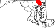
U.S. Highways Interstate Highways Categories:- State highways in Maryland
- Roads in Harford County, Maryland


Wikimedia Foundation. 2010.