- Maryland Route 131
-
Maryland Route 131
Seminary Avenue 
Route information Maintained by MDSHA Length: 3.06 mi[1] (4.92 km) Major junctions West end:  MD 25 in Lutherville, Maryland
East end:  MD 45 in Lutherville, Maryland
Highway system Maryland highway system
Interstate • US • State • Minor • Former • Turnpikes←  MD 130
MD 132  →
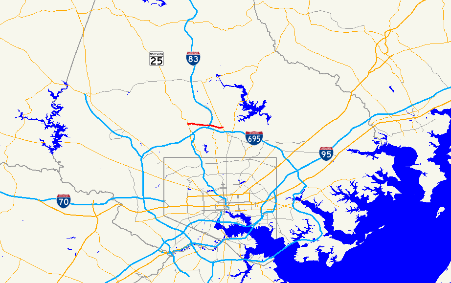
→Maryland Route 131 (MD 131), identified locally as Seminary Avenue, is a route in Baltimore County that runs from the area of Lutherville known as Brooklandville to Providence Road in Parkville. The route runs east–west, parallel to and just slightly north of the Baltimore Beltway, and is used by motorists often as an alternative route to the beltway when I-695 is congested. The entire route is lined with upscale housing and communities, except for some commercial development at the intersection of York Road.
Contents
Route description
Beginning at its western terminus at MD 25, Seminary Avenue begins as a two-lane road in the community of Brooklandville, home to the St. Paul's School, St. Paul's School for Girls, and Maryvale. Seminary Avenue is a long, winding road with only a few traffic signals. The road is lined with forest in the western end, and later with middle to upper middle class homes. After passing over Interstate 83 and then the Baltimore Light Rail at-grade, the first major intersection along the roadway is York Road. After crossing MD 45, Seminary Avenue loses its designation as MD 131 and becomes a county-maintained roadway, continuing as a two-way road, crossing Dulaney Valley Road and finally ending at Providence Road.[1][2]
Public transportation
There are no bus lines that actually operate on Seminary Avenue itself. However, regular frequent bus service is available on Route 8 on York Road, which the route crosses.
The Central Light Rail Line crosses Seminary Avenue at grade level, requiring gates to block traffic when trains are passing; however, there is no light rail stop at this location. When the light rail started operating in 1992, area residents complained that the frequent warning signals blasted by the trains that passed every 15 minutes in each direction until around midnight disturbed their sleep.[3]
In the past, several bus routes operated on portions of Seminary Avenue, including Routes 11 and 26. However, Route 26 has since been eliminated, and Route 11 modified.
Junction list
The entire route is in Lutherville, Baltimore County.
Mile
[1]Roads intersected Notes 0.00 MD 25 (Falls Road)Western terminus 3.06 MD 45 (York Road)Eastern terminus References
- ^ a b c Maryland State Highway Administration (2008). "Highway Location Reference: Baltimore County" (PDF). http://apps.roads.maryland.gov/KeepingCurrent/performTrafficStudies/dataAndStats/hwyLocationRef/2008_hlr_all/co03.pdf. Retrieved 2010-04-21.
- ^ Google, Inc. Google Maps – overview of Maryland Route 131 (Map). Cartography by Google, Inc. http://maps.google.com/maps?f=d&source=s_d&saddr=maryland+131+and+maryland+25&daddr=maryland+131+and+maryland+45&geocode=FdOYWQIdoxNu-ykfnaaWsBHIiTGnaLqylMeoNg%3B&hl=en&mra=ls&sll=39.423597,-76.619167&sspn=0.057152,0.169086&ie=UTF8&t=h&z=14. Retrieved 2010-04-28.
- ^ Carson, Larry (1992-10-06). "Horns to keep sounding in Lutherville". http://pqasb.pqarchiver.com/baltsun/access/113515559.html?dids=113515559:113515559&FMT=ABS&FMTS=ABS:FT&type=current&date=Oct+06%2C+1992&author=Larry+Carson&pub=The+Sun&desc=Horns+to+keep+sounding+in+Lutherville&pqatl=google.
Categories:- State highways in Maryland
- Roads in Baltimore County, Maryland

Wikimedia Foundation. 2010.