- Maryland Route 407
-
Maryland Route 407
Marston Road 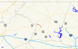
Route information Maintained by MDSHA Length: 3.81 mi[1] (6.13 km) Major junctions West end:  MD 31 near Marston
East end:  MD 27 near Taylorsville
Location Counties: Carroll Highway system Maryland highway system
Interstate • US • State • Minor • Former • Turnpikes←  MD 406
MD 408  →
→Maryland Route 407 (MD 407) is a state highway in the U.S. state of Maryland. Known as Marston Road, the state highway runs 3.81 miles (6.13 km) from MD 31 near Marston east to MD 27 near Taylorsville. MD 407 was constructed in the early to mid-1930s.
Contents
Route description
MD 407 begins at an intersection with MD 31 (New Windsor Road) northwest of Marston and south of New Windsor. The state highway heads southeast as a two-lane road through farmland to the village of Marston, where the highway turns east at a three-way junction with South Marston Road. East of Marston, MD 407 veers southeast and passes through the hamlet of Dennings. The state highway reaches its eastern terminus at MD 27 (Ridge Road) north of Taylorsville. The roadway continues southeast as county-maintained Baker Road, which leads to the historic McMurray-Frizzell-Aldridge Farm.[1][2]
History
Construction on the first section of MD 407 from MD 31 through Marston began shortly after 1930.[3] That section and a second segment to west of Dennings were completed as a concrete road by 1933.[4][5] The final portion through Dennings to MD 27 was completed in 1936.[6] MD 407 has changed very little since it was constructed.
Junction list
The entire route is in Carroll County.
Location Mile
[1]Destinations Notes Marston 0.00 MD 31 (New Windsor Road) – Libertytown, New WindsorWestern terminus Taylorsville 3.81 MD 27 (Ridge Road) / Baker Road east – Mount Airy, WestminsterEastern terminus 1.000 mi = 1.609 km; 1.000 km = 0.621 mi References
- ^ a b c "Highway Location Reference: Carroll County" (PDF). Maryland State Highway Administration. 2009. http://www.marylandroads.com/Location/2009_CARROLL.pdf. Retrieved 2011-04-29.
- ^ Google, Inc. Google Maps – Maryland Route 407 (Map). Cartography by Google, Inc. http://maps.google.com/maps?f=d&source=s_d&saddr=MD-407+S%2FMarston+Rd&daddr=MD-407+S%2FMarston+Rd&hl=en&geocode=FWj5WgId-Ghn-w%3BFShxWgIdlBdo-w&mra=ls&sll=39.481371,-77.063776&sspn=0.001867,0.004823&ie=UTF8&ll=39.499405,-77.086601&spn=0.059739,0.154324&t=h&z=13. Retrieved 2011-04-29.
- ^ Report of the State Roads Commission of Maryland. 1927-1930. Baltimore: Maryland State Roads Commission. 1930-10-01. p. 203. http://www.archive.org/details/reportofstateroa1927mary. Retrieved 2011-04-29.
- ^ Report of the State Roads Commission of Maryland. 1931-1934. Baltimore: Maryland State Roads Commission. 1934-12-28. p. 326. http://www.archive.org/details/reportofstateroa1931mary. Retrieved 2011-04-29.
- ^ Maryland Geological Survey. Map of Maryland Showing State Road System: State Aid Roads and Improved County Road Connections (Map) (1933 ed.).
- ^ Maryland State Roads Commission. Map of Maryland Showing State Road System (Map) (1936 ed.).
External links
Roads in Carroll County, Maryland State highways 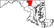
U.S. Highways Interstate Highways Categories:- State highways in Maryland
- Roads in Carroll County, Maryland


Wikimedia Foundation. 2010.