- Maryland Route 86
-
Maryland Route 86

Route information Maintained by MDSHA Length: 4.00 mi[1] (6.44 km) Major junctions South end:  MD 30 in Manchester
North end:  PA 516 in Lineboro
Location Counties: Carroll Highway system Maryland highway system
Interstate • US • State • Minor • Former • Turnpikes←  MD 85
MD 85MD 87  →
→Maryland Route 86 (MD 86) is a state highway in the U.S. state of Maryland. Known as Lineboro Road, the state highway runs 4.00 miles (6.44 km) from MD 30 in Manchester north to the Pennsylvania state line in Lineboro, where the highway continues as Pennsylvania Route 516 (PA 516). MD 86 was constructed in the late 1920s; the MD 30 junction was reconfigured due to residential development around 2008.
Contents
Route description
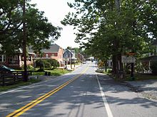 MD 86 northbound in Lineboro
MD 86 begins at an intersection with MD 30 (Hanover Pike) on the north side of the town of Manchester. A left turn is prohibited from southbound MD 30 to northbound MD 86; southbound MD 30 traffic has to use use municipally-maintained Hallie Avenue to access MD 86. MD 86 heads northeast through farmland just south of the parallel Dug Hill Ridge and north of a tributary of the South Branch of Gunpowder Falls. The tributary passes under the state highway and enters the South Branch just south of MD 86's intersection with Water Tank Road, where MD 86 crosses the South Branch. The state highway continues northeast as the main street of the village of Lineboro. MD 86 crosses over the North Branch of Gunpowder Falls and meets CSX's Hanover Subdivision at grade while passing through the Lineboro Historic District. The state highway reaches its northern terminus at the Pennsylvania state line. Lineboro Road continues northeast as PA 516 toward Glen Rock.[1][2]
History
The first 1-mile (1.6 km) concrete section of MD 86 was constructed from Manchester in 1925.[3][4] A second section was completed in 1928.[5] MD 86 was completed as a concrete road through Lineboro to the Pennsylvania state line in 1929 and 1930.[6][7] Around 2008, in conjunction with the construction of residential subdivisions, the MD 30–MD 86 intersection was modified to prohibit left turns from MD 30 to MD 86 to improve traffic flow on MD 30. The possibility of turning the intersection into a right-in/right-out intersection allowing access to and from MD 86 only from northbound MD 30 was considered but postponed for further study. The right-in/right-out configuration may be implemented in the future, which would require both directions of traffic between MD 86 and southbound MD 30 to use Hallie Avenue as a connector.[8]
Junction list
The entire route is in Carroll County.
Location Mile
[1]Destinations Notes Manchester 0.00 MD 30 (Hanover Pike) – HanoverSouthern terminus; no direct access from southbound MD 30 to northbound MD 86 Lineboro 4.00 PA 516 north (Lineboro Road) – Glen RockNorthern terminus; Pennsylvania state line 1.000 mi = 1.609 km; 1.000 km = 0.621 mi References
- ^ a b c "Highway Location Reference: Carroll County" (PDF). Maryland State Highway Administration. 2009. http://www.marylandroads.com/Location/2009_CARROLL.pdf. Retrieved 2011-04-23.
- ^ Google, Inc. Google Maps – Maryland Route 86 (Map). Cartography by Google, Inc. http://maps.google.com/maps?f=d&source=s_d&saddr=Hanover+Pike%2FMain+St&daddr=MD-86+S%2FE+Main+St&geocode=FYJ4XQIdmrlq-w%3BFTwWXgId2Hxr-w&hl=en&mra=ls&sll=39.718939,-76.843936&sspn=0.007444,0.01929&ie=UTF8&t=h&z=13. Retrieved 2011-04-23.
- ^ Report of the State Roads Commission of Maryland. 1924-1926. Baltimore: Maryland State Roads Commission. January 1927. p. 73. http://www.archive.org/details/annualreportsofs1924mary. Retrieved 2011-04-23.
- ^ Maryland Geological Survey. Map of Maryland: Showing State Road System and State Aid Roads (Map) (1927 ed.).
- ^ Maryland Geological Survey. Map of Maryland: Showing State Road System and State Aid Roads (Map) (1928 ed.).
- ^ Report of the State Roads Commission of Maryland. 1927-1930. Baltimore: Maryland State Roads Commission. 1930-10-01. p. 202. http://www.archive.org/details/reportofstateroa1927mary. Retrieved 2011-04-23.
- ^ Maryland Geological Survey. Map of Maryland Showing State Road System: State Aid Roads and Improved County Road Connections (Map) (1930 ed.).
- ^ D'Amario, Christopher; Coyne, David A. (2008-10-21). "Letter to Joe Chaffman and Residents of Hallie Hill Section One" (PDF). Town of Manchester, Maryland. http://www.manchestermd.org/PDF/HallieHillPressRelease.PDF. Retrieved 2011-04-23.
External links
Roads in Carroll County, Maryland State highways 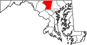
U.S. Highways Interstate Highways Categories:- State highways in Maryland
- Roads in Carroll County, Maryland


Wikimedia Foundation. 2010.