- Maryland Route 4
-
Maryland Route 4
St. Andrew's Church Road, Patuxent Beach Road, Solomons Island Road, Southern Maryland Boulevard, Pennsylvania Avenue 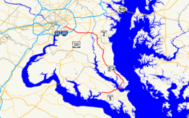
Maryland Route 4 highlighted in redRoute information Maintained by MDSHA Length: 64.85 mi[1][2][3][4] (104.37 km) Existed: 1927 – present Major junctions South end:  MD 5 in Leonardtown
 MD 235 in California
 MD 2 in Solomons
 MD 231 in Prince Frederick
MD 2 in Sunderland
 MD 260 in Lyons Creek
 US 301 in Upper Marlboro
 MD 223 in Mellwood
Suitland Parkway in Meadows

 I-95 / I-495 in Forestville
 MD 458 in District Heights
North end: Pennsylvania Avenue in Washington, D.C. Highway system Maryland highway system
Interstate • US • State • Minor • Former • Turnpikes←  MD 3
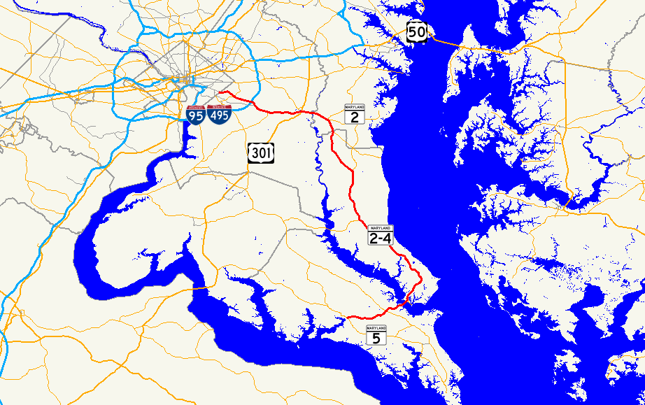
MD 3MD 5 →Maryland Route 4 (MD 4) is a state highway in the U.S. state of Maryland. The state highway runs 64.85 miles (104.37 km) from MD 5 in Leonardtown north to Southern Avenue at the Washington, D.C. border, past which the highway continues as Pennsylvania Avenue. MD 4 is a major commuter route in Southern Maryland, connecting Washington and suburbs in Prince George's County, Anne Arundel County, and Calvert County. MD 4 also connects residential communities in southern Calvert County with employment centers in St. Mary's County, including Naval Air Station Patuxent River. In conjunction with U.S. Route 301 (US 301) and MD 2, MD 4 also provides interregional connections with Baltimore and Annapolis, respectively. MD 4 is part of the National Highway System between MD 235 in California and its northern terminus.[5]
MD 4 heads east from Leonardtown as St. Andrew's Church Road and then Patuxent Beach Road east of MD 235. The state highway crosses the Patuxent River on the Governor Thomas Johnson Bridge between California and Solomons, then joins MD 2 north through Prince Frederick. At 27.40 miles (44.10 km), MD 2/MD 4 is the longest state-numbered highway concurrency in Maryland.[2] MD 4 and MD 2 separate at Sunderland, with MD 4 heading northwest as Southern Maryland Boulevard to a second crossing of the Patuxent River near Upper Marlboro. The state highway heads west as Pennsylvania Avenue toward Washington.
MD 4 is one of the original Maryland state highways. The state highway followed roughly its present alignment through Prince George's County, then headed east through Anne Arundel County along what is now MD 408. In the 1960s, MD 4 took over MD 416 (Southern Maryland Boulevard) southeast to Sunderland and joined MD 2 all the way to Solomons. After the Governor Thomas Johnson Bridge opened in the late 1970s, MD 4 was extended west from Solomons to Leonardtown. MD 4 has been upgraded to a divided highway for most of its length, beginning in the early 1960s from Washington, reaching Solomons in the mid 1980s, and expected to continue into St. Mary's County in the 2010s.
Contents
Route description
St. Andrew's Church Road and Patuxent Beach Road
MD 4 begins at an intersection with MD 5 (Point Lookout Road) in Leonardtown. The state highway heads east as St. Andrew's Church Road, a two-lane road with a speed limit of 50 mph (80 km/h) through a mix of forest and farmland.[1] After intersecting Indian Bridge Road, which becomes MD 471 closer to Great Mills, MD 4 turns northeast and passes St. Andrew's Church.[6] The state highway crosses the St. Mary's River adjacent to St. Mary's River State Park and passes by residential subdivisions before intersecting MD 235 (Three Notch Road) in California.[6]
MD 4 continues northeast as Patuxent Beach Road, a controlled access two-lane highway through scattered residential subdivisions.[1] The state highway crosses Kingston Creek and intersects two old segments of Patuxent Beach Road. The speed limit drops to 45 mph (72 km/h) as MD 4 begins to cross the Governor Thomas Johnson Bridge.[1] The bridge crosses Town Creek before curving to the northeast over the Patuxent River.[1][6] After an exit for Solomons, the state highway is joined by MD 2 (Solomons Island Road) in a long concurrency through Calvert County that is often referenced as MD 2-4.[6]
Solomons Island Road
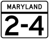 Highway marker used along the MD 2/MD 4 concurrency
Shortly after the concurrency begins, MD 2-4 expands to a four-lane controlled-access divided highway passing through a mix of shopping centers and residential subdivisions.[2][6] The state highway is closely paralleled on the east by the old alignment, MD 765 (H.G. Trueman Road), from the beginning of the concurrency to the intersection with Dowell Road.[6] Beyond Dowell Road, MD 765 heads further away from MD 2-4, which becomes surrounded by forest as the speed limit increases to 55 mph (89 km/h).[2][6] As the state highway approaches Lusby, the highway intersects Southern Connector Boulevard as well as Coster Road and Mill Bridge Road.[2] MD 2-4 turns northeast to meet the northern end of MD 760 (Rousby Hall Road), then turns north to pass the western end of MD 497 (Cove Point Road).[6]
After MD 2-4 turns northwest beyond Lusby, the divided highway intersects MD 765. MD 765 south (H.G. Trueman Road) leads to Calvert Cliffs State Park, while MD 765 north (Pardoe Road) provides access to Sollers Wharf Road.[6] After crossing Johns Creek and passing Nursery Road, the state highway passes Calvert Cliffs Parkway, which leads to the Calvert Cliffs Nuclear Power Plant, and Flag Ponds Parkway, which provides access to Flag Ponds Nature Park.[2][6] After crossing Quaker Swamp (Woodland Branch), MD 2-4 continues northwest through St. Leonard, where the old alignment splits to the east as MD 765 (St. Leonard Road).[2] The state highway turns north and intersects Ball Road, which heads west to Mutual, and Calvert Beach Road, which heads east toward the twin beach communities of Calvert Beach and Long Beach.[6] MD 2-4 turns northwest through Port Republic, where the divided highway meets the northern end of the St. Leonard Road section of MD 765 and intersects MD 264 (Broomes Island Road).[6]
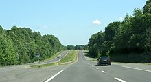 MD 2/MD 4 southbound in Calvert County
MD 2-4 continues northwest without access controls, with scattered residences and businesses lining the highway.[2] The divided highway passes MD 506, then the next iteration of MD 765 (Main Street) splits to the east to serve Prince Frederick.[6] After passing Westlake Boulevard, the speed limit drops to 45 mph (72 km/h) and the highway becomes lined with shopping centers.[2][6] MD 2-4 intersects MD 231 (Hallowing Point Road), then turns north to intersect the northern end of MD 765 and cross the west end of MD 402 (Dares Beach Road).[6] Beyond the intersection with Stoakley Road, the speed limit increases to 55 mph (89 km/h) and the state highway continues north through scattered residences and businesses.[2] After intersecting the west end of MD 263, MD 2-4 crosses Hunting Creek and enters Huntingtown. The old alignment splits to the west as MD 524 (Old Town Road), which leads to MD 521 (Hunting Creek Road).[6] MD 2-4 passes Huntingtown High School and meets the northern end of MD 524. After intersecting Pond Woods Road, the divided highway continues straight north to the end of the MD 2-MD 4 concurrency in Sunderland.[6]
Southern Maryland Boulevard
As MD 2 heads northeast toward Annapolis, MD 4 veers northwest as Southern Maryland Boulevard and immediately intersects MD 262 (Lower Marlboro Road).[2] The state highway continues as a four-lane divided highway with a speed limit of 55 mph (89 km/h) through a mix of farms and residential subdivisions through Chaneyville, where the highway passes Chaneyville Road and Mount Harmony Road, the latter being the old alignment of MD 260.[2][6] MD 4 turns north and enters the village of Dunkirk, where the highway passes shopping centers and Ferry Landing Road.[6] The state highway continues through the residential community of Lyons Creek, where the highway meets MD 260 (Chesapeake Beach Road) at a trumpet interchange that is missing the MD 260 west to MD 4 south movement and simultaneously crosses Lyons Creek.[6]
Upon entering Anne Arundel County, MD 4 gains a wide, forested median[3][6] The state highway reaches Bristol, where the median narrows and the state highway meets MD 258 (Bay Front Road) at a diamond interchange.[6] MD 258 provides access to a frontage road, MD 794, which leads to MD 259 (Greenock Road). From the MD 258 interchange, MD 4 curves to the northwest and becomes a freeway.[3] After a few off-ramps to the frontage roads and a right-in/right-out interchange southbound with Plummer Lane, the state highway curves to the west and meets the original path of MD 4, MD 408 (Mt. Zion-Marlboro Road), at a diamond interchange at Waysons Corner[6]. MD 4 makes its second crossing of the Patuxent River on Hills Bridge and enters Prince George's County, where its name changes to Pennsylvania Avenue.[4] Parts of Patuxent River Park, Jug Bay Wetlands Sanctuary and Patuxent Wetland Park are adjacent to Rt. 4 here at this popular Patuxent River fishing and paddling put-in location.
Pennsylvania Avenue
After crossing Hills Bridge, MD 4 immediately meets Marlboro Pike, the old alignment of MD 4, at a partial interchange that also involves Green Landing Road.[6] The state highway continues west to intersect US 301 (Crain Highway) at a cloverleaf interchange and cross CSX's Pope's Creek Subdivision.[6] MD 4 has a diamond interchange with Water Street (unsigned MD 717), which leads to the Prince George's County government offices as well as the Prince George's Equestrian Center and Show Place Arena.[6] The state highway crosses the Western Branch of the Patuxent River, then meets Old Crain Highway (at a partial interchange).[6] The median widens ahead of the partial interchange with Ritchie-Marlboro Road, then closes up ahead of the partial cloverleaf interchange with MD 223 (Woodyard Road), which leads to the historic home Melwood Park.[6]
MD 4 downgrades from a freeway to a controlled access highway at the intersection with Dower House Road and Marlboro Pike, after which the highway expands to six lanes, curves to the northwest, and abuts Andrews Air Force Base.[4] Access to the military base is provided through the intersection with the Suitland Parkway, which leads to MD 337. After an intersection with Old Marlboro Pike and Westphalia Road, MD 4 intersects the Capital Beltway at a cloverleaf interchange, where the state highway becomes four lanes again.[6]. All but four miles of the previous 54 miles of MD 4 are in the Patuxent River watershed. The five miles west of the Beltway are in the Oxon Run watershed within the drainage of the Potomac River; the southernmost six miles fall within the Potomac watershed as well.
MD 4 enters a dense suburban area with residential subdivisions and shopping centers upon crossing Forestville Road, which leads to the old alignment Marlboro Pike in Forestville.[6] After intersecting MD 458 (Silver Hill Road) and Brooks Drive in District Heights, MD 4 turns west through Coral Hills, where the speed limit drops to 35 mph (56 km/h).[4] The state highway passes Cedar Hill Cemetery on the south, then reaches its northern terminus at Southern Avenue on the Washington, D.C. border.[4] Pennsylvania Avenue continues northwest straight toward downtown Washington.[6]
History
MD 4 in Prince George's County was originally the Washington and Marlborough Turnpike, which exited the District of Columbia on Bowen Road, headed east to Forestville, south to Meadows, then east through Upper Marlboro to Hills Bridge on the Patuxent River.[7][8] An unnamed road continued east to Solomons Island Road in Lothian.[8] When the Maryland State Roads Commission was established in 1908, this route became one of the original state roads. In 1910, the highway was paved from the D.C. border to what is today District Heights, as well as from Hills Bridge to Waysons Corner, where MD 4 meets MD 408 today.[9] Marlboro Pike from the D.C. line to Hills Bridge and Mt. Zion Road between Hills Bridge and Lothian was fully paved by 1927, which was the same year MD 4 was assigned to the two named roads.[10] Southern Maryland Boulevard was built between Waysons Corner and MD 2 in Sunderland in 1929 and 1930, and was designated MD 416 by 1933.[11][12][13]
Pennsylvania Avenue was extended east out of D.C. to Meadows as a controlled access four-lane divided highway in 1959 and 1960 and was designated MD 4.[11][14] Marlboro Pike was assigned MD 4 Business, a designation that was gone by 1970.[14][15] Also in 1960, the MD 416 designation was extended south along MD 2 to Solomons.[14] By 1970, the MD 4 freeway between Meadows and Hills Bridge was complete.[15] In addition, MD 4 replaced MD 416 down Southern Maryland Boulevard and Solomons Island Road to Solomons, and the divided highway was extended south from Hills Bridge to MD 263.[11][15] In turn, MD 408 was placed on what was previously MD 4 between Upper Marlboro and Lothian.[15] The western extent of MD 408 was rolled back to Waysons Corner by 1980.[16] MD 2-4 was also expanded to a divided highway south to Port Republic by 1980.[16]
The next major change in the routing of MD 4 came in 1977, when the Governor Thomas Johnson Bridge was completed.[11][16] The St. Mary's County side of the bridge unloaded onto county highways until 1982, when the modern, controlled access Patuxent Beach Road was completed to MD 235.[11][17] MD 4 was then extended west from Solomons along Patuxent Beach Road and St. Andrew's Church Road to its present southern terminus in Leonardtown.[17] MD 2-4 bypassed Port Republic and St. Leonard along a new alignment in 1984.[18] The bypass of the old alignment between Lusby and Solomons was completed in 1985.[19] The MD 4 freeway was extended to Bristol in 1993 and the interchange at MD 260 was completed in 2003.[11][20][21]
Future
As of 2010, construction is underway to improve the intersection of MD 2-4 and MD 231 in Prince Frederick.[22] This project is a prelude to a larger project to expand MD 2-4 to six lanes between MD 765 south of Prince Frederick and Stoakley Road north of Prince Frederick.[23] Another future project along MD 4 involves upgrading the highway between MD 223 in Mellwood and the Capital Beltway in Forestville to a freeway featuring interchanges at the Suitland Parkway, Dower House Road, and Westphalia Road.[24] There is also a planning study underway to explore building a new bridge adjacent to the Governor Thomas Johnson Bridge and expanding MD 4 to a four-lane divided highway between MD 2 at Solomons and MD 235 in California.[25]
Junction list
County Location Mile
[1][2][3][4]Destinations Notes St. Mary's 9.36 miles (15.06 km)
Leonardtown 0.00 MD 5 (Point Lookout Road) – Leonardtown, St. Mary's CitySouthern terminus 3.55 Indian Bridge Road south to  MD 471 – Great Mills
California 6.10 MD 235 (Three Notch Road) – Waldorf, Lexington ParkGovernor Thomas Johnson Bridge – Patuxent River Calvert 36.43 miles (58.63 km)
Solomons 10.07 MD 2 south (Solomons Island Road) – SolomonsSouth end of concurrency with MD 2 11.31 Dowell Road east to  MD 765 – Dowell
Dowell Road is former MD 504 Lusby 12.38 Southern Connector Boulevard east to MD 765 – Drum Point12.73 Coster Road / Mill Bridge Road – Coster Coster Road is former MD 505 13.16  MD 760 south (Rousby Hall Road) – Drum Point
14.26  MD 497 east (Cove Point Road) – Chesapeake Ranch Estates
16.00 MD 765 (H.G. Trueman Road) to Sollers Wharf RoadSollers Wharf Road is former MD 266 St. Leonard 19.53 MD 765 north (St. Leonard Road) – St. LeonardPort Republic 24.52  MD 264 south (Broomes Island Road) / MD 765 south (St. Leonard Road) – Mutual, Port Republic
26.13  MD 506 west (Sixes Road) – Adelina
Prince Frederick 26.85 MD 765 north (Main Street) – Prince Frederick28.41 MD 231 (Hallowing Point Road) – Hughesville28.97 MD 765 south (Main Street) – Prince Frederick29.11  MD 402 east (Dares Beach Road) – Dares Beach
30.03 Stoakley Road west Former MD 507 31.88  MD 263 east (Plum Point Road) – Plum Point
Huntingtown 34.11  MD 524 north (Old Town Road) to MD 521 south (Hunting Creek Road) – Huntingtown
34.79 MD 524 south (Old Town Road) – Huntingtown35.38 Pond Woods Road east Former MD 575 Sunderland 37.47 MD 2 north (Solomons Island Road) – Annapolis, BaltimoreNorth end of concurrency with MD 2 37.63  MD 262 (Lower Marlboro Road) – Lower Marlboro
Chaneyville 40.17 Chaneyville Road west – Lower Marlboro Former MD 523 41.21 Mount Harmony Road east Old alignment of MD 260 Dunkirk 42.68 Ferry Landing Road west Former MD 525 Lyons Creek 45.59 MD 260 east (Chesapeake Beach Road) – Chesapeake Beach, North BeachTrumpet interchange; no access from MD 260 west to MD 4 south Lyons Creek Anne Arundel 4.77 miles (7.68 km)
Bristol 48.65 

 MD 258 east (Bay Front Road) / MD 259 north (Greenock Road) / MD 794 north (Southern Maryland Boulevard) – Deale
Diamond interchange 49.09 Plummer Lane Southbound right-in/right-out interchange Waysons Corner 50.06  MD 408 east (Mt. Zion Road) / MD 794 south (Southern Maryland Boulevard) – Lothian
Diamond interchange Hills Bridge – Patuxent River Prince George's 14.29 miles (23.00 km)
Upper Marlboro 51.08 Marlboro Pike west – Upper Marlboro Old alignment of MD 4; Northbound exit, southbound entrance 51.99 US 301 (Crain Highway) – Bowie, Waldorf, Baltimore, RichmondCloverleaf interchange 51.99 Water Street – Upper Marlboro Unsigned MD 717; diamond interchange 53.48 Old Crain Highway – Upper Marlboro, Marlton Old alignment of US 301; Southbound exit, northbound entrance 54.16 Ritchie–Marlboro Road west – Greater Upper Marlboro Former MD 221 Mellwood 56.87 MD 223 south (Woodyard Road) – ClintonPartial cloverleaf interchange Meadows 58.24 Dower House Road south / Marlboro Pike east – Rosaryville Marlboro Pike is old alignment of MD 4 58.99 Suitland Parkway west to  MD 337 west – Andrews Air Force Base, Camp Springs, Washington
Forestville 59.93 I-95 / I-495 (Capital Beltway) – College Park, Baltimore, Alexandria, RichmondI-95/I-495 Exit 11 60.35 Forestville Road to Marlboro Pike – Forestville Former MD 534 District Heights 62.48 MD 458 (Silver Hill Road) – District Heights, SuitlandCoral Hills 64.85 Pennsylvania Avenue / Southern Avenue – Washington Northern terminus References
- ^ a b c d e f "Highway Location Reference: St. Mary's County" (PDF). Maryland State Highway Administration. 2008. http://apps.roads.maryland.gov/KeepingCurrent/performTrafficStudies/dataAndStats/hwyLocationRef/2008_hlr_all/co18.pdf. Retrieved 2010-02-12.
- ^ a b c d e f g h i j k l m "Highway Location Reference: Calvert County" (PDF). Maryland State Highway Administration. 2008. http://apps.roads.maryland.gov/KeepingCurrent/performTrafficStudies/dataAndStats/hwyLocationRef/2008_hlr_all/co04.pdf. Retrieved 2010-02-12.
- ^ a b c d "Highway Location Reference: Anne Arundel County" (PDF). Maryland State Highway Administration. 2008. http://apps.roads.maryland.gov/KeepingCurrent/performTrafficStudies/dataAndStats/hwyLocationRef/2008_hlr_all/co02.pdf. Retrieved 2010-02-12.
- ^ a b c d e f "Highway Location Reference: Prince George's County" (PDF). Maryland State Highway Administration. 2008. http://apps.roads.maryland.gov/KeepingCurrent/performTrafficStudies/dataAndStats/hwyLocationRef/2008_hlr_all/co16.pdf. Retrieved 2010-02-12.
- ^ Federal Highway Administration (August 2003) (PDF). National Highway System: Maryland (Map). http://www.fhwa.dot.gov/planning/nhs/maps/md/md_Maryland.pdf. Retrieved 2010-02-14.
- ^ a b c d e f g h i j k l m n o p q r s t u v w x y z aa ab ac ad ae Google, Inc. Google Maps – Maryland Route 4 (Map). Cartography by Google, Inc. http://maps.google.com/maps?f=d&source=s_d&saddr=md-5+and+md-4+leonardtown,+md&daddr=md-4+and+md-2+sunderland,+md+to:pennsylvania+ave+and+southern+ave+washington,+dc&hl=en&geocode=Fd0wSAIdZuBu-ymrHu-ZFGa3iTHvo8jI20T6IA%3BFYfqTQId5RFv-ymjIDXh74S3iTHzJOHpXHXhkw%3BFTsDUQIdgOJp-yltplQxF7m3iTH_NFD5EiqYpg&mra=ls&sll=38.859093,-76.94026&sspn=0.030544,0.077162&ie=UTF8&t=h&z=9. Retrieved 2010-02-14.
- ^ United States Geological Survey. Upper Marlboro-East Washington quadrangle (Map). 1:48,000. 15 Minute Series (Topographic) (1886 ed.). http://historical.mytopo.com/quad.cfm?quadname=Upper%20Marlboro-East%20Washington&state=DC&series=15. Retrieved 2010-02-13.
- ^ a b U.S. Geological Survey. Owensville quadrangle (Map). 1:48,000. 15 Minute Series (Topographic) (1892 ed.). http://historical.mytopo.com/quad.cfm?quadname=Owensville&state=MD&series=15. Retrieved 2010-02-13.
- ^ Maryland Geological Survey (JPG). Map of Maryland (Map) (1910 ed.). http://www.mdhighwaycentennial.com/images/template/gallery/maps/1910-1-500000.jpg. Retrieved 2010-02-13.
- ^ Maryland State Roads Commission (JPG). Map of Maryland (Map) (1927 ed.). http://www.mdhighwaycentennial.com/images/template/gallery/maps/1927SIDE1.jpg. Retrieved 2010-02-13.
- ^ a b c d e f Svirsky, Alexander. "National Bridge Inventory Database". http://nationalbridges.com/. Retrieved 2010-02-13.
- ^ Maryland State Roads Commission (JPG). Map of Maryland (Map) (1930 ed.). http://commons.wikimedia.org/wiki/File:Maryland_State_Highway_Map_-_1930.jpg. Retrieved 2010-02-13.
- ^ Maryland State Roads Commission (PDF). Map of Maryland (Map) (1933 ed.). http://commons.wikimedia.org/wiki/File:Maryland_State_Highway_Map_-_1933.pdf. Retrieved 2010-02-13.
- ^ a b c Maryland State Roads Commission (PDF). Map of Maryland (Map) (1960 ed.). http://commons.wikimedia.org/wiki/File:Maryland_State_Highway_Map_-_1960.pdf. Retrieved 2010-02-13.
- ^ a b c d Maryland State Roads Commission (PDF). Map of Maryland (Map) (1970 ed.). http://commons.wikimedia.org/wiki/File:Maryland_State_Highway_Map_-_1970.pdf. Retrieved 2010-02-13.
- ^ a b c Maryland State Highway Administration (PDF). Map of Maryland (Map) (1980 ed.). http://commons.wikimedia.org/wiki/File:Maryland_State_Highway_Map_-_1980.pdf. Retrieved 2010-02-13.
- ^ a b "Traffic Volume Map" (PDF). Maryland State Highway Administration. 1982. http://www.marylandroads.com/Traffic_Volume_Maps/82_Traffic_Volume_Maps.pdf. Retrieved 2010-02-13.
- ^ "Traffic Volume Map" (PDF). Maryland State Highway Administration. 1984. http://www.marylandroads.com/Traffic_Volume_Maps/84_Traffic_Volume_Maps.pdf. Retrieved 2010-02-13.
- ^ "Traffic Volume Map" (PDF). Maryland State Highway Administration. 1985. http://www.marylandroads.com/Traffic_Volume_Maps/85_Traffic_Volume_Maps.pdf. Retrieved 2010-02-13.
- ^ "Traffic Volume Map" (PDF). Maryland State Highway Administration. 1993. http://www.marylandroads.com/Traffic_Volume_Maps/93_Traffic_Volume_Maps.pdf. Retrieved 2010-02-13.
- ^ "Highway Location Reference: Calvert County" (PDF). Maryland State Highway Administration. 2003. http://apps.roads.maryland.gov/KeepingCurrent/performTrafficStudies/dataAndStats/hwyLocationRef/2003_hlr_all/co04.pdf. Retrieved 2010-02-13.
- ^ "Project Information: MD 0002 MD 2/4 (SOLOMONS ISLAND ROAD) MD 2/4 AND MD 231 FROM SOUTH OF COMMERCE LANE TO OLD FIELD LANE". Maryland State Highway Administration. http://www.marylandroads.com/WebProjectLifeCycle/ProjectInformation.asp?projectno=CA313514. Retrieved 2010-02-14.
- ^ "Project Information: MD 0002 SOLOMONS ISLAND ROAD NORTH OF STOAKLEY ROAD TO SOUTH OF MD 765". Maryland State Highway Administration. http://www.marylandroads.com/WebProjectLifeCycle/ProjectInformation.asp?projectno=CA413214. Retrieved 2010-02-14.
- ^ "Project Information: MD 0004 PENNSYLVANIA AVENUE I-95 (CAPITAL BELTWAY TO MD 223". Maryland State Highway Administration. http://www.marylandroads.com/WebProjectLifeCycle/ProjectInformation.asp?projectno=PG9171116. Retrieved 2010-02-14.
- ^ "Project Information: MD 0004 SOLOMONS ISLAND RD/PATUXENT BEACH RD UPGRADE BETWEEN MD 2 AND MD 235". Maryland State Highway Administration. http://www.marylandroads.com/WebProjectLifeCycle/ProjectInformation.asp?projectno=SM3511118. Retrieved 2010-02-14.
External links
Roads in Prince George's County, Maryland Maryland State Highways 
U.S. Routes Interstate Highways Roads by name Roads in Calvert County, Maryland State highways 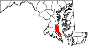
Roads in St. Mary's County, Maryland State highways 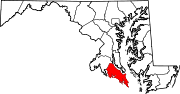 Categories:
- State highways in Maryland
- Roads in Prince George's County, Maryland
- Roads in Anne Arundel County, Maryland
- Roads in Calvert County, Maryland
- Roads in St. Mary's County, Maryland


Wikimedia Foundation. 2010.