- Maryland Route 704
-
Maryland Route 704
Martin Luther King Jr. Highway 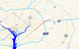
Maryland Route 704 highlighted in redRoute information Maintained by MDSHA Length: 6.53 mi[1] (10.51 km) Major junctions West end: Eastern Avenue in Seat Pleasant 
 I-595 / US 50 in Lanham
East end:  MD 450 in Lanham
Highway system Maryland highway system
Interstate • US • State • Minor • Former • Turnpikes←  MD 702
MD 707  →
→Maryland Route 704 (MD 704) is a state highway in the U.S. state of Maryland. Known as Martin Luther King Jr. Highway, the state highway runs 6.53 mi (10.51 km) from Eastern Avenue at the District of Columbia boundary in Seat Pleasant east to MD 450 in Lanham.
MD 704 was constructed in the early 1940s from Seat Pleasant to U.S. Route 50 (now MD 450) along the right-of-way of the abandoned Washington, Baltimore and Annapolis Electric Railway. The highway was expanded to a multi-lane divided highway west of US 50 in the 1960s and 1970s and at its eastern end in 2000.
Contents
Route description
MD 704 begins at an intersection with Eastern Avenue near the eastern corner of the District of Columbia boundary. The highway continues south as 63rd Avenue, which heads south toward Southern Avenue and East Capitol Street.[2] MD 704 heads northeast as a six-lane divided highway through the town of Seat Pleasant, where the highway intersects Addison Road.[1][2] After leaving the town, the state highway crosses Cabin Branch and intersects Sheriff Road at an oblique angle. MD 704 passes through Palmer Park, where the highway traverses Cattail Branch and meets MD 202 (Landover Road) at a full cloverleaf interchange.[2] MD 704 temporarily drops to four lanes through the MD 202 interchange.[1]
MD 704 continues through Glenarden, where the highway intersects Ardwick Ardmore Road and crosses the Capital Beltway (Interstate 95 and I-495) with no access.[1] MD 704 drops to four lanes again between Ardwick Ardmore Road and the five-ramp interchange at unsigned I-595 and US 50, which features a direct ramp to northbound I-95 and I-495 toward Baltimore. MD 704 continues northeast as a six-lane highway across Bald Hill Branch, through office parks, and past a shopping center before reaching its eastern terminus at MD 450 (Annapolis Road) in Lanham.[1][2]
History
MD 704 was constructed in 1942 on the right-of-way of the Washington, Baltimore and Annapolis Electric Railway, which had ceased operations in 1935.[3][4][5] The highway was originally named for George N. Palmer, a community leader in Seat Pleasant.[4] MD 704 was temporarily marked as Temp US 50 when John Hanson Highway's western terminus was at MD 704 between 1959 and the highway's completion west to Washington in the early 1960s.[6] The state highway was expanded to a divided highway from Glenarden to just east of John Hanson Highway around 1964 and within Seat Pleasant by 1970.[7][8] MD 704 was expanded to a divided highway from Seat Pleasant to Glenarden around 1970.[7][9] MD 704 was renamed for Martin Luther King, Jr. between 1986 and 1999.[10][11] The final two-lane portion of the state highway, from just east of US 50 to MD 450, was expanded to a six-lane divided highway in 2000.[12]
Junction list
The entire route is in Prince George's County.
Location Mile
[1]Destinations Notes Seat Pleasant 0.00 63rd Street south to Southern Avenue and East Capitol Street Western terminus Eastern Avenue 0.27 Addison Road south – District Heights Former MD 389 Palmer Park 3.02  MD 202 (Landover Road) – Landover, Largo
Cloverleaf interchange Lanham 5.16 
 I-595 / US 50 (John Hanson Highway) to I-95 / I-495 (Capital Beltway) – Annapolis, Baltimore, Washington, Richmond
I-595 is unsigned 6.53 MD 450 (Annapolis Road) – New Carrollton, BowieEastern terminus References
- ^ a b c d e f "Highway Location Reference: Prince George's County" (PDF). Maryland State Highway Administration. 2008. http://apps.roads.maryland.gov/KeepingCurrent/performTrafficStudies/dataAndStats/hwyLocationRef/2008_hlr_all/co16.pdf. Retrieved 2010-05-23.
- ^ a b c d Google, Inc. Google Maps – Maryland Route 704 (Map). Cartography by Google, Inc. http://maps.google.com/maps?f=d&source=s_d&saddr=MD-704%2FMartin+Luther+King+Jr+Hwy&daddr=MD-704&hl=en&geocode=FZJ5UQIdHG9q-w%3BFSxrUgIdksVr-w&mra=ls&sll=38.895676,-76.906486&sspn=0.007632,0.01929&ie=UTF8&t=h&z=12. Retrieved 2010-05-23.
- ^ Report of the State Roads Commission of Maryland. 1941-1942. Baltimore: Maryland State Roads Commission. 1943-03-15. p. 95. http://www.archive.org/details/reportofstateroa1941mary. Retrieved 2010-05-23.
- ^ a b "Seat Pleasant, Maryland". Maryland Municipal League. http://www.mdmunicipal.org/cities/index.cfm?townname=seatpleasant. Retrieved 2010-05-23.
- ^ Maryland State Roads Commission (PDF). Map of Maryland (Map) (1946 ed.). http://commons.wikimedia.org/wiki/File:Maryland_State_Highway_Map_-_1946.pdf. Retrieved 2010-05-23.
- ^ Maryland State Roads Commission (PDF). Map of Maryland (Map) (1959 ed.). http://commons.wikimedia.org/wiki/File:Maryland_State_Highway_Map_-_1959.pdf. Retrieved 2010-05-23.
- ^ a b Svirsky, Alexander. "National Bridge Inventory Database". http://nationalbridges.com/. Retrieved 2010-05-23.
- ^ Maryland State Roads Commission (PDF). Map of Maryland (Map) (1970 ed.). http://commons.wikimedia.org/wiki/File:Maryland_State_Highway_Map_-_1970.pdf. Retrieved 2010-05-23.
- ^ Maryland State Highway Administration (PDF). Map of Maryland (Map) (1980 ed.). http://commons.wikimedia.org/wiki/File:Maryland_State_Highway_Map_-_1980.pdf. Retrieved 2010-05-23.
- ^ "Traffic Volume Map" (PDF). Maryland State Highway Administration. 1986. http://www.marylandroads.com/Traffic_Volume_Maps/86_Traffic_Volume_Maps.pdf. Retrieved 2010-05-23.
- ^ "Highway Location Reference: Prince George's County" (PDF). Maryland State Highway Administration. 1999. http://apps.roads.maryland.gov/KeepingCurrent/performTrafficStudies/dataAndStats/hwyLocationRef/Allint_99_hlr/co16.pdf. Retrieved 2010-05-23.
- ^ "Highway Location Reference: Prince George's County" (PDF). Maryland State Highway Administration. 2000. http://apps.roads.maryland.gov/KeepingCurrent/performTrafficStudies/dataAndStats/hwyLocationRef/2000_hlr_all/co16.pdf. Retrieved 2010-05-23.
External links
Roads in Prince George's County, Maryland Maryland State Highways 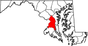
U.S. Routes Interstate Highways Roads by name Categories:- State highways in Maryland
- Roads in Prince George's County, Maryland


Wikimedia Foundation. 2010.