- Maryland Route 320
-
Maryland Route 320
Piney Branch Road 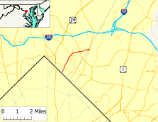
Route information Maintained by MDSHA Length: 2.84 mi[1][2] (4.57 km) Major junctions South end: Eastern Avenue at the Washington, D.C. border  MD 410 in Takoma Park
 MD 787 in Silver Spring
 MD 193 in Silver Spring
North end:  MD 650 in Adelphi
Highway system Maryland highway system
Interstate • US • State • Minor • Former • Turnpikes←  MD 318
MD 322  →
→Maryland Route 320 (MD 320) is a state highway in the U.S. state of Maryland. Known as Piney Branch Road, the route runs 2.84 mi (4.57 km) from Eastern Avenue at the Washington, D.C. border north to Maryland Route 650 in Adelphi.
Contents
Route description
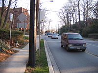 MD 320 eastbound at Manchester Road in Silver Spring
Maryland Route 320 begins at Eastern Avenue. Piney Branch Road continues into Washington, where it underpasses CSX's Metropolitan Subdivision, MARC's Brunswick Line, and the Red Line of the Washington Metro about 300 ft (91 m) to the southwest of MD 320's southern terminus, then continues on to intersect U.S. Route 29 (Georgia Avenue) and then turn into 13th Street N.W. Following Eastern Avenue headed southeast leads to Old Town Takoma Park, the Takoma Park Historic District, and the Takoma station of the Washington Metro. Following Eastern Avenue in the northwest direction leads to the Takoma Park/Silver Spring Campus of Montgomery College.
MD 320 heads northeast as a two-lane road with a speed limit of 30 mph (48 km/h) through a densely-populated residential area in the city of Takoma Park, Maryland. At Chestnut Avenue, which is former Maryland Route 540, the road veers to the north ahead of the intersection with Maryland Route 410 (Philadelphia Avenue). After crossing MD 410, MD 320 returns to a northeast heading and passes Takoma Park Middle School, where the road enters Silver Spring and widens to three lanes with a center turn lane. After passing Sligo Avenue, which was formerly Maryland Route 339, the road enters a small commercial area and enters an acute intersection with Dale Drive, which was formerly Maryland Route 391. MD 320 then descends to Sligo Creek and intersects Sligo Creek Parkway and the Sligo Creek Trail.
After crossing Sligo Creek Parkway, MD 320 gains a second lane northbound as it leaves the creek valley, turns east, and enters a commercial area with apartment complexes. The road expands to five lanes with a center turn lane prior to the intersection with Maryland Route 787 (Flower Avenue). After two traffic signals and a nonchalant crossing of Long Branch, the road intersects Maryland Route 193 (University Boulevard). After crossing MD 193, the speed limit increases to 40 mph (64 km/h) and the road passes a series of apartment buildings and Quebec Terrace Park as the road goes downhill. On the way down, the road intersects Carroll Avenue, a county-maintained street that links up to Maryland Route 195. The road enters Prince George's County immediately before crossing Northwest Branch and reaching its northern terminus at Maryland Route 650 (New Hampshire Avenue) in Adelphi.
History
Maryland Route 320 originally had its southern terminus at the Seventh Street Pike (now Georgia Avenue and U.S. Route 29) in Silver Spring. The road headed east on Sligo Avenue to its present course, then northeast along the present course to what is now MD 650. The road then followed current MD 650 north to its northern terminus at Colesville Road, which is today the intersection of MD 650 and Lockwood Drive in White Oak. In 1927, this route was paved from the southern terminus to Carroll Avenue.[3] By 1933, the remainder of the road north to White Oak had been paved.[4] The 1939 Maryland state highway map shows that route as MD 320.[5]

In Takoma Park, the stretch of current road between Chestnut Avenue and Sligo Avenue was paved in 1933.[4] The whole length was paved and was assigned MD 513 by 1939.[5] MD 320 achieved its present configuration in 1955, when MD 320 replaced MD 513 in Takoma Park and MD 650 replaced MD 320 between Adelphi and White Oak.[6]
Junction list
County Location Mile[1][2] Destinations Notes Montgomery 2.68 mi (4.31 km)
Takoma Park 0.00 Eastern Avenue Piney Branch Road
Southern terminus Piney Branch Road continues south
0.33 Chestnut Avenue Former MD 540 0.39 MD 410 (Philadelphia Avenue) – Takoma Park, Silver SpringSilver Spring 1.00 Sligo Avenue / Park Valley Road Former MD 339 1.20 Dale Drive Former MD 391 1.43 Sligo Creek Parkway 1.63 MD 787 south (Flower Avenue) – Takoma Park2.09 MD 193 (University Boulevard) – Wheaton, Langley Park2.34 Carroll Avenue To  MD 195 south
Prince George's 0.16 mi (0.26 km)
Adelphi 2.84 MD 650 (New Hampshire Avenue) – White Oak, Langley ParkNorthern terminus References
- ^ a b Maryland State Highway Administration (2008). "Highway Location Reference: Montgomery County" (PDF). http://apps.roads.maryland.gov/KeepingCurrent/performTrafficStudies/dataAndStats/hwyLocationRef/2008_hlr_all/co15.pdf. Retrieved 2010-01-12.
- ^ a b Maryland State Highway Administration (2008). "Highway Location Reference: Prince George's County" (PDF). http://apps.roads.maryland.gov/KeepingCurrent/performTrafficStudies/dataAndStats/hwyLocationRef/2008_hlr_all/co16.pdf. Retrieved 2010-01-12.
- ^ Maryland State Highway Administration (1927). "Map of Maryland" (JPG). http://www.mdhighwaycentennial.com/images/template/gallery/maps/1927SIDE1.jpg. Retrieved 2010-01-13.
- ^ a b Maryland State Highway Administration (1933). "Map of Maryland" (PDF). http://commons.wikimedia.org/wiki/File:Maryland_State_Highway_Map_-_1933.pdf. Retrieved 2010-01-13.
- ^ a b Maryland State Highway Administration (1939). "Map of Maryland" (PDF). http://commons.wikimedia.org/wiki/File:Maryland_State_Highway_Map_-_1939.pdf. Retrieved 2010-01-13.
- ^ Maryland State Highway Administration (1955). "Map of Maryland" (PDF). http://commons.wikimedia.org/wiki/File:Maryland_State_Highway_Map_-_1955.pdf. Retrieved 2010-01-13.
External links
Roads in Montgomery County, Maryland Maryland State Highways 
U.S. Routes Interstate Highways Roads by name Cabin John Parkway · Clara Barton Parkway · Cherry Hill Road · Connecticut Avenue · Georgia Avenue · Montrose Road · New Hampshire Avenue · Randolph Road · Sligo Creek Parkway · Wisconsin Avenue · 16th StreetRoads in Prince George's County, Maryland Maryland State Highways 
U.S. Routes Interstate Highways Roads by name Categories:- State highways in Maryland
- Roads in Prince George's County, Maryland
- Roads in Montgomery County, Maryland


Wikimedia Foundation. 2010.