- Maryland Route 192
-
Maryland Route 192
Plyers Mill Road, Metropolitan Avenue, Capitol View Avenue, Forest Glen Road 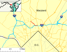
Route information Maintained by MDSHA Length: 2.59 mi[1] (4.17 km) Major junctions West end: Summit Avenue in Kensington
Seminary Road in Forest Glen MD 185 in Kensington
East end:  MD 97 in Forest Glen
Highway system Maryland highway system
Interstate • US • State • Minor • Former • Turnpikes←  MD 191
MD 193  →
→Maryland Route 192 (MD 192) is a state highway in the U.S. state of Maryland. The route runs 2.59 mi (4.17 km) from Summit Avenue in Kensington to Maryland Route 97 (Georgia Avenue) in Forest Glen. MD 192 provides access to the Forest Glen station of the Washington Metro and the Washington D.C. Temple of The Church of Jesus Christ of Latter-day Saints.
Contents
Route description
Maryland Route 192 begins as Plyers Mill Road at its intersection with Summit Avenue in Kensington. Plyers Mill Road continues as a county-maintained residential street to the west, while Summit Avenue crosses the railroad tracks of the Metropolitan Subdivision of CSX and MARC Train's Brunswick Line. The 500 ft (150 m) segment between Summit Avenue and Maryland Route 185 (Connecticut Avenue) is maintained by the town of Kensington. State maintenance begins to the east of MD 185. Shortly after the intersection with MD 185, Plyers Mill Road continues straight while MD 192 continues east on Metropolitan Avenue as a two-lane road with a speed limi of 25 mph (40 km/h). Within the town of Kensington, the road passes through an area of shops and light industry.
East of Kensington, MD 192 assumes a residential character as it continues to parallel the railroad tracks. At Meredith Avenue, the name of the road changes to Capitol View Avenue and the road follows several sharp curves as is moves away from the tracks. On one of those curves is an intersection with Stoneybrook Drive, which leads to the Washington D.C. Temple and Beach Drive. MD 192 returns to the tracks in time for a few more sharp curves and the road's intersection with Forest Glen Road and Seminary Road. Seminary Road, which was formerly designated Maryland Route 391, continues straight. Forest Glen Road to the west crosses the railroad tracks at a level crossing and continues as Linden Lane toward the former National Park Seminary. MD 192 turns east onto Forest Glen Road.
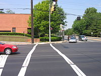
The Forest Glen Road segment of MD 192 is a two-lane road with a speed limit of 30 mph (48 km/h). The road continues through residential areas and passes a churches and a few cemeteries. The road expands to a four-lane divided highway at Darcy Forest Drive, which is used to access the park and ride of the Forest Glen Metro Station. The kiss and ride and bus stops are accessed opposite Elkton Avenue. MD 192 comes to an end at Maryland Route 97 (Georgia Avenue). Forest Glen Road continues east as a county-maintained road.
History
Maryland Route 192 was entirely paved by 1927.[2] However, the route through Kensington was different; MD 192 followed St. Paul Street from Metropolitan Avenue north to Maryland Route 193. The 1939 Maryland state highway map shows MD 192 assigned to its present length.[3] By 1946, the route was extended east along Forest Glen Road to U.S. Route 29, engulfing Maryland Route 597.[4] In 1950, MD 192 assumed its present routing in Kensington.[5] By 1970, the route was rolled back from U.S. 29 to Sligo Creek Parkway.[6]
Junction list
The entire route is in Montgomery County.
Location Mile[1] Destinations Notes Kensington 0.00 Summit Avenue Western terminus 0.10 MD 185 (Connecticut Avenue) – Chevy Chase, Aspen HillFollow north to 0.16 Plyers Mill Road  continues east on Metropolitan Avenue
0.84 Meredith Avenue 1.20 Stoneybrook Drive Follow to Beach Drive Forest Glen 1.85 Seminary Road Forest Glen Road
Seminary Road was formerly 
2.27 Darcy Forest Drive To Forest Glen Metro Station 2.53 MD 97 (Georgia Avenue) – Wheaton, Silver SpringEastern terminus References
- ^ a b Maryland State Highway Administration (2008). "Highway Location Reference: Montgomery County" (PDF). http://apps.roads.maryland.gov/KeepingCurrent/performTrafficStudies/dataAndStats/hwyLocationRef/2008_hlr_all/co15.pdf. Retrieved 2010-01-05.
- ^ Maryland State Highway Administration (1927). "Map of Maryland" (JPG). http://www.mdhighwaycentennial.com/images/template/gallery/maps/1927SIDE1.jpg. Retrieved 2010-01-05.
- ^ Maryland State Highway Administration (1939). "Map of Maryland" (PDF). http://commons.wikimedia.org/wiki/File:Maryland_State_Highway_Map_-_1939.pdf. Retrieved 2010-01-05.
- ^ Maryland State Highway Administration (1946). "Map of Maryland" (PDF). http://commons.wikimedia.org/wiki/File:Maryland_State_Highway_Map_-_1946.pdf. Retrieved 2010-01-05.
- ^ Maryland State Highway Administration (1950). "Map of Maryland" (PDF). http://commons.wikimedia.org/wiki/File:Maryland_State_Highway_Map_-_1950.pdf. Retrieved 2010-01-05.
- ^ Maryland State Highway Administration (1970). "Map of Maryland" (PDF). http://commons.wikimedia.org/wiki/File:Maryland_State_Highway_Map_-_1970.pdf. Retrieved 2010-01-05.
External links
Roads in Montgomery County, Maryland Maryland State Highways 
U.S. Routes Interstate Highways Roads by name Cabin John Parkway · Clara Barton Parkway · Cherry Hill Road · Connecticut Avenue · Georgia Avenue · Montrose Road · New Hampshire Avenue · Randolph Road · Sligo Creek Parkway · Wisconsin Avenue · 16th StreetCategories:- State highways in Maryland


Wikimedia Foundation. 2010.