- Maryland Route 109
-
Maryland Route 109 Old Hundred Rd. 
Route information Maintained by MDSHA Length: 11.87 mi[1] (19.10 km) Major junctions South end:  MD 107 in Poolesville
 I-270
I-270North end:  MD 355 in Hyattstown
Highway system Maryland highway system
Interstate • US • State • Minor • Former • Turnpikes←  MD 108
MD 112  →
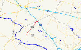
→Maryland Route 109 is a Maryland state highway that goes from MD 107 in Poolesville, Maryland to MD 355 in Hyattstown, Maryland. The entire route is in Montgomery County.
Route description
Maryland Route 109 begins at MD 107 in Poolesville, beginning as Elgin Road, a city street. It travels to the north out the city, where it diverges from Elgin Road onto Beallsville Road. It begins to pass neatly through the open countryside, sometimes passing through patches of forest. Homes begin to front the road as it enters Beallsville, where the route intersects MD 28. After this intersection, the route curves to the northeast, where it passes through a small patch of forest and fields, eventually passing under the Brunswick Line of MTA Maryland's MARC Train service. After the rail line, the fields give way to more homes, eventually growing denser as the route enters Barnesville.[1][2]
Inside Barnesville, MD 109 turns east onto Barnesville Road, leaving this road to the north at the very next intersection. Now following Old Hundred Road, MD 109 passes through a vast stretch of woodland, giving way to fields and homes again as it passes through Comus. Re-entering the woodland, the route turns east as it skirts the Frederick County border for a short stretch (but not leaving the county), bearing straight toward its partial cloverleaf interchange with Interstate 270. The route finally comes to an end in Hyattstown at its intersection with MD 355.[1][2]
Junction list
The entire route is in Montgomery County.
Location Mile
[1]Roads intersected Notes Poolesville 0.00  MD 107 east (Fisher Avenue)
Southern terminus Beallsville 2.41  MD 28 (Darnestown Road)
Hyattstown 11.35  I-270 (Eisenhower Memorial Highway) – Frederick, Washington
I-270 exit 22 11.87 
 MD 355 (Frederick Road) to MD 75
Northern terminus References
- ^ a b c d Maryland State Highway Administration (2008). "Highway Location Reference: Montgomery County" (PDF). http://apps.roads.maryland.gov/KeepingCurrent/performTrafficStudies/dataAndStats/hwyLocationRef/2008_hlr_all/co15.pdf. Retrieved 2010-04-21.
- ^ a b Google, Inc. Google Maps – overview of Maryland Route 109 (Map). Cartography by Google, Inc. http://maps.google.com/maps?f=d&source=s_d&saddr=maryland+109+and+maryland+107&daddr=maryland+109+and+maryland+355&hl=en&geocode=FUxSVQId3LZi-ymNr5hMJCW2iTG8c_LknC5OpQ%3BFexgVwIde0Rk-ynHFJOr3im2iTFkMNn16uDffQ&mra=ls&sll=39.135005,-77.38004&sspn=0.030425,0.084543&ie=UTF8&t=h&z=11. Retrieved 2010-04-26.
Roads in Montgomery County, Maryland Maryland State Highways 
U.S. Routes Interstate Highways Roads by name Cabin John Parkway · Clara Barton Parkway · Cherry Hill Road · Connecticut Avenue · Georgia Avenue · Montrose Road · New Hampshire Avenue · Randolph Road · Sligo Creek Parkway · Wisconsin Avenue · 16th StreetCategories:- State highways in Maryland
- Roads in Montgomery County, Maryland
Wikimedia Foundation. 2010.

