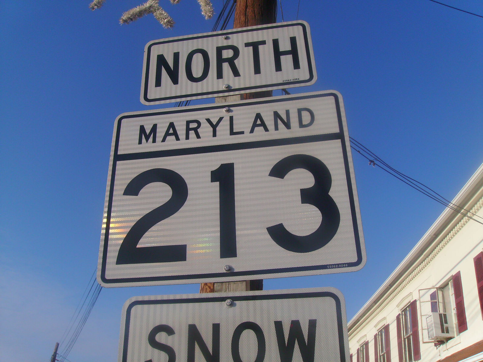
- Maryland Route 213
-
Maryland Route 213
College Drive, Centreville Road, Church Hill Road, Augustine Herman Highway, Singerly Road, Lewisville Road 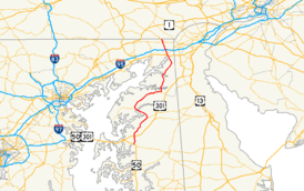
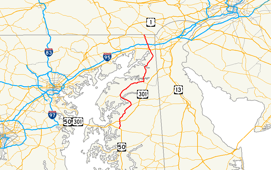
Route information Maintained by MDSHA and USACE Length: 68.25 mi[1][2][3] (109.84 km) Major junctions South end:  MD 662 in Wye Mills
 US 50 near Wye Mills
 US 301 near Centreville
 MD 18 in Centreville

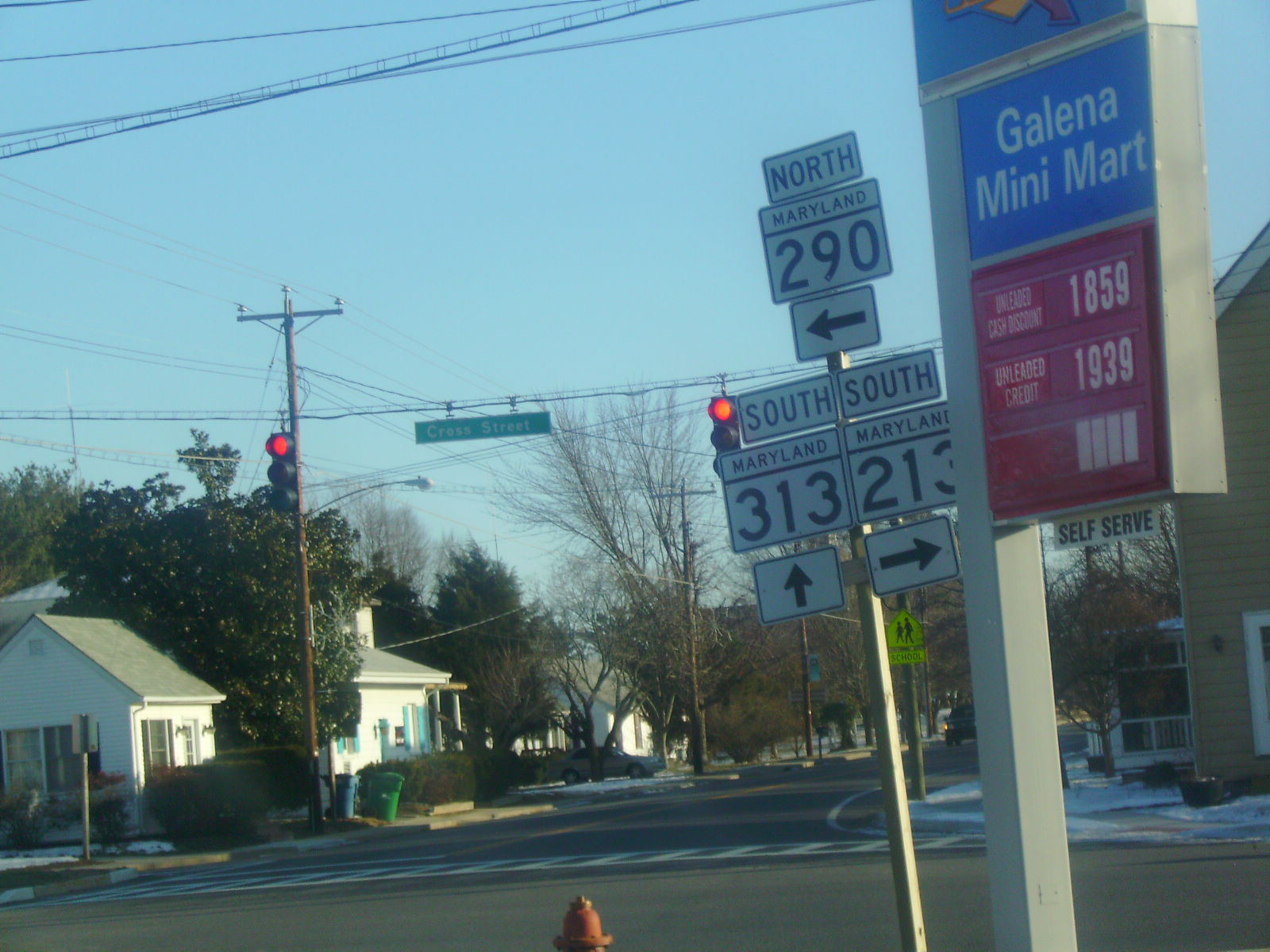
 MD 290 / MD 313 in Galena
 US 40 in Elkton
 MD 7 in Elkton
 MD 279 in Elkton
North end:  PA 841 at Pennsylvania border near Lewisville, PA
Location Counties: Queen Anne's, Kent, Cecil Highway system Maryland highway system
Interstate • US • State • Minor • Former • Turnpikes←  MD 212
MD 214  →
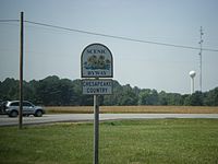
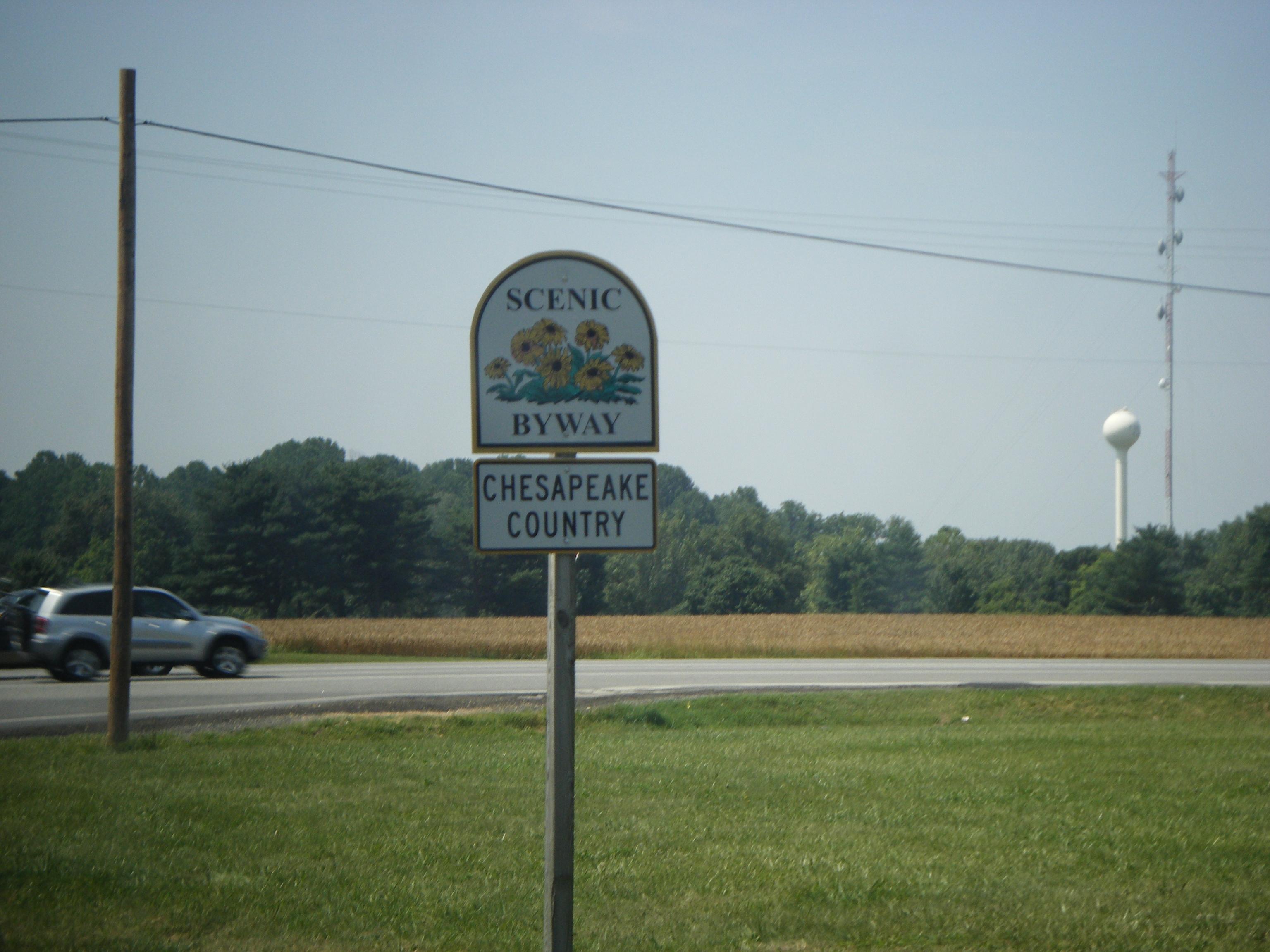
→Maryland Route 213 (MD 213) is a 68.25-mile (109.84 km) state highway located on the Eastern Shore of Maryland in the United States. The route runs from Maryland Route 662 in Wye Mills, Queen Anne's County north to the Pennsylvania border in Cecil County, where it continues into that state as Pennsylvania Route 841. The route, which is a two-lane undivided highway its entire length, passes through mostly rural areas as well as the communities of Centreville, Chestertown, Galena, Cecilton, Chesapeake City, and Elkton. MD 213 intersects many routes including U.S. Route 50 near Wye Mills, U.S. Route 301 near Centreville, and U.S. Route 40 in Elkton. It crosses over the Chesapeake and Delaware Canal in Chesapeake City on the Chesapeake City Bridge. Maryland Route 213 is designated by the state as the Chesapeake Country Scenic Byway between the southern terminus and Chesapeake City with the portion north of Maryland Route 18 in Centreville a National Scenic Byway. In addition, the route is also considered part of the Atlantic to Appalachians Scenic Byway between Chesapeake City and Maryland Route 273 in Fair Hill.
The route was initially designated as U.S. Route 213 in 1926 when the U.S. Highway System was established, running from Ocean City to US 40 in Elkton. By 1940, it was realigned to the US 50 corridor between Mardela Springs and Easton, having previously followed Maryland Route 313, Maryland Route 14, and Maryland Route 331 between these two points, and Maryland Route 280 was designated along current MD 213 north of US 40. In 1949, US 50 replaced US 213 south of Wye Mills. The route was then downgraded to MD 213 by 1975, and was subsequently extended to the Pennsylvania border along the alignment of MD 280, whose signs consequently were taken down.
Contents
Route description
Queen Anne's County
 Shield for Chesapeake Country Scenic Byway on MD 213 southbound before intersection with US 50 in Wye Mills
Maryland Route 213 begins at an intersection with Maryland Route 662 (Wye Mills Road) in Wye Mills, Queen Anne's County, heading to the north on College Drive, a two-lane undivided road with a 40 mph (64 km/h) speed limit.[1] From the southern terminus, MD 213 is designated by the state as the Chesapeake Country Scenic Byway.[4] The road heads into rural farmland, passing Chesapeake College on the left before intersecting U.S. Route 50 (Ocean Gateway).[5] Past this intersection, MD 213 continues north on 55 mph (89 km/h) Centreville Road, passing more farms as well as some residences. The route continues into a mix of woods and farmland before intersecting the northern terminus of Maryland Route 309 (Starr Road). A short distance later, the route interchanges with U.S. Route 301 (Blue Star Memorial Highway). Past the US 301 interchange, MD 213 continues through more rural areas before entering Centreville, where the speed limit drops to 30 mph (48 km/h) and it passes some residential and commercial areas. It intersects Maryland Route 18 (4H Park Road).[1][5] At this intersection, MD 213 becomes a part of the National Scenic Byway portion of the Chesapeake Country Scenic Byway.[6] Past MD 18, the route continues into residential areas, eventually splitting into a one-way pair with northbound MD 213 following Commerce Street and southbound MD 213 following Liberty Street.[1][5] This pairing continues past residences, with the speed limit dropping to 25 mph (40 km/h), before heading into the downtown area, where the road intersects Maryland Route 304 (Water Street).[1][5] Westbound MD 304 secretly joins northbound MD 213 for a concurrency that lasts until Broadway, where it continues to the west.[5]
 Shield for northbound MD 213
MD 213 leaves downtown Centreville, with the speed limit increasing back to 30 mph (48 km/h). The one-way pair ends and the route continues north on two-lane undivided Liberty Street, passing by residences and some businesses.[1][5] At the end of the one-way pair, the route sees an average of 12,912 vehicles daily.[1] It intersects the western terminus of Maryland Route 305 (Hope Road), and passes by more residences as a 30 mph (48 km/h) road before becoming 55 mph (89 km/h) Church Hill Road, which heads north into a mix of woods and farms with some housing developments.[1][5] It angles to the northeast and then north through more rural areas, consisting mostly of farm fields with some wooded areas and occasional residences. MD 213 continues in a northeast direction before reaching Church Hill.[5] Upon reaching Church Hill, the route intersects Maryland Route 19A (South Main Street), which loops to the east of MD 213 to head into the town.[1] Meanwhile, MD 213 bypasses Church Hill to the west, running through woodland, and intersects the western terminus of Maryland Route 300 (Sudlersville Road).[5] The route heads back into farmland and intersects Maryland Route 19 (North Main Street), leaving the Church Hill area. MD 213 continues north through a mix of woods and farms. From here, the route turns northwest through more farmland before it passes some residences and businesses near the intersection with the western terminus of Maryland Route 544 (Mcginnis Road).[1][5] Past the MD 544 intersection, the road continues through rural areas as a 50 mph (80 km/h) road, but residences and businesses start to increase. MD 213 passes through Kingstown, where the speed limit drops to 30 mph (48 km/h) before crossing the Chester River on a drawbridge.[5]
Kent County
Upon crossing the Chester River, MD 213 enters Chestertown, Kent County, where the route heads northwest on Maple Avenue, a 25 mph (40 km/h) street through residential areas. It intersects Maryland Route 289 (Cross Street) in the downtown area and turns north onto Washington Avenue at the intersection with Spring Avenue.[2][5] Washington Avenue carries MD 213 north through residential neighborhoods and passes by Washington College.[5] Past the college, the route continues past businesses and intersects Maryland Route 291 (Morgnec Road). Past this intersection, the speed limit increases to 40 mph (64 km/h) and MD 213 continues through residential and commercial areas.[2][5] The road leaves Chestertown and becomes Augustine Herman Highway, which is named for Dutch surveyor Augustine Herman.[7] The speed limit rises to 45 mph (72 km/h) as the road heads into farmland with residences along the west side of the road. MD 213 intersects Maryland Route 297 (Worton Road) and the speed limit increases to 55 mph (89 km/h) as it heads past more farm fields. The road turns northeast and intersects Maryland Route 561 (Hassenger’s Corner Road).[2][5] It continues through more rural areas, consisting mostly of farms with some wooded areas before reaching Kennedyville, where the speed limit decreases to 30 mph (48 km/h) and MD 213 passes residences. In Kennedyville, the road crosses over a Maryland & Delaware Railroad line.[2][5]
Upon leaving Kennedyville, the speed limit becomes 55 mph (89 km/h) again and it continues back into agricultural areas. The route makes a turn to the east, with an old bypassed segment remaining as unsigned Maryland Route 855. MD 213 intersects Maryland Route 298 (Browntown Road) and resumes northeast and east again. It intersects unsigned Maryland Route 449 (Shallcross Wharf Road), which connects to Maryland Route 444 (Kentmore Park Road), which MD 213 intersects a short distance later.[2][5] From here, the route continues east and northeast through more farmland before heading into a mix of farms and woods.[2][5] The route enters Galena, where it becomes Cross Street and the speed limit drops to 25 mph (40 km/h).[2] In the center of town, MD 213 meets Maryland Route 290 and Maryland Route 313 at the intersection with Main Street. Here, MD 290 and MD 313 continue south on Main Street, MD 290 continues east on Cross Street, and MD 213 makes a left turn to head north on Main Street.[5] Main Street passes residences before leaving Galena, where the road becomes Augustine Herman Highway again, with the speed limit rising to 45 mph (72 km/h). The road continues through a mix of farms and woods before reaching Georgetown, where the speed limit decreases to 30 mph (48 km/h) and the route passes some homes before crossing the Sassafras River on a drawbridge near a marina.[2][5]
Cecil County
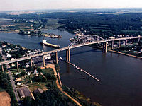
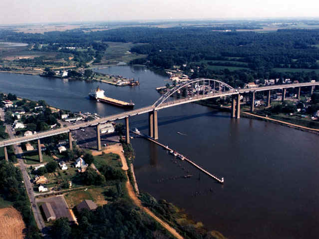
MD 213 enters Cecil County upon crossing the Sassafras River, where it continues north through wooded and agricultural areas with some residences, with the speed limit increasing back to 55 mph (89 km/h).[3][5] The route enters Cecilton, where the speed limit drops to 30 mph (48 km/h) and it becomes Bohemia Avenue.[3] In Cecilton, MD 213 passes residences and intersects Maryland Route 282 (Main Street) in the center of town. Upon leaving Cecilton, the name of the road becomes Augustine Herman Highway again and the speed limit climbs back to 55 mph (89 km/h).[3][5] MD 213 passes through farmland, with intermittent woods and rural residences, before crossing over the Bohemia River.[5] Past the Bohemia River, the road turns northeast through more rural areas before intersecting the western terminus of Maryland Route 310 (Cayots Corner Road). Past MD 310, the route continues through farms and woods with some residences and businesses before heading into the Chesapeake City area, where residences increase along the road and the speed limit drops to 50 mph (80 km/h). Upon reaching Chesapeake City, MD 213 features an interchange with Maryland Route 537, which provides access to the southern portion of Chesapeake City as well as to Maryland Route 286 and Maryland Route 342.[3][5] In Chesapeake City, the Chesapeake Country Scenic Byway ends and MD 213 continues north as a part of the Atlantic to Appalachians Scenic Byway which crosses the state of Maryland.[4][6] Past this interchange, MD 213 passes over the Chesapeake and Delaware Canal on the Chesapeake City Bridge. Upon crossing the canal, the road intersects Maryland Route 285 (Lock Street), which provides access to the northern portion of Chesapeake City. Past MD 285, the route resumes through a mix of woodland and farmland, with residential areas increasing along the road.[5] It approaches the Elkton area. From here, the speed limit drops to 35 mph (56 km/h) and the road heads through residential areas.[3][5]
MD 213 enters Elkton at the intersection with U.S. Route 40 (Pulaski Highway).[3] Past this intersection, the route heads northwest on Bridge Street, passing through commercial areas, with the speed limit dropping to 25 mph (40 km/h). The route intersects Howard Street, which carries the westbound direction of Maryland Route 7 that turns onto northbound MD 213. Westbound MD 7 follows the route to the intersection with Main Street, where it turns left to join with the eastbound direction of MD 7, which continues east of MD 213 on a one-way street.[3][5] Past MD 7, the road continues north and passes over Amtrak's Northeast Corridor before intersecting Maryland Route 545 (Elkton Boulevard). MD 213 continues past commercial areas to the west and residential areas to the east as a 30 mph (48 km/h) road before its intersection with Maryland Route 279 (Elkton Road/Newark Avenue).[3][5] Past the MD 279 intersection, the route leaves Elkton and becomes Singerly Road, a 55 mph (89 km/h) which continues past residences. It enters a mix of woods and farms, with the speed limit decreasing to 45 mph (72 km/h) and MD 213 passes over Interstate 95 (John F. Kennedy Memorial Highway) and CSX's Philadelphia Subdivision within a short distance of each other. It continues through a mix of farms and residences before the speed limit decreases to 25 mph (40 km/h) and the road reaches the Leeds roundabout with Leeds Road. The speed limit increases back to 45 mph (72 km/h) past the roundabout and the route resumes north, intersecting Maryland Route 273 (Telegraph Road) in Fair Hill west of the Fair Hill Training Center, where the Atlantic to Appalachians Scenic Byway leaves MD 213 and heads west along MD 273.[3][4][5] From here, MD 213 continues northwest and west as Lewisville Road through a mix of rural areas and residences before ending at the Pennsylvania border. Here, the road continues north as Pennsylvania Route 841 into Lewisville, intersecting the southern terminus of Pennsylvania Route 472 just north of the state line.[5]
History
The route was originally designated as U.S. Route 213 with the creation of the U.S. Highway System in 1926, running from Ocean City north to US 40 in Elkton.[8] The route ran along what is now Maryland Route 707 and Maryland Route 346 to Salisbury, where it intersected with its parent route, U.S. Route 13. From Salisbury, US 213 followed the present US 50 corridor to Mardela Springs, where it turned north on MD 313 and followed that route to Eldorado. Here, the route ran along present-day Maryland Route 14 and Maryland Route 331 to Easton, where it continued north along current MD 662 and MD 213 to Elkton.[9] By 1940, US 213 was realigned between Mardela Springs and Easton to follow the present US 50 corridor, crossing the Choptank River at Cambridge on the Emerson C. Harrington Bridge that opened in 1935.[10][11] Also by this time, Maryland Route 280 was designated along present-day MD 213 between US 40 and the Pennsylvania border.[11] On July 28, 1942, the vertical lift bridge carrying US 213 over the Chesapeake and Delaware Canal, built in 1927, was destroyed when the tanker Franz Klasen struck it. The destroyed bridge was replaced by the current Chesapeake City Bridge, which opened in 1949.[12] The approaches to the original bridge are now designated as MD 537 and a western extension of MD 285.[3][5] In 1949, the route was replaced by U.S. Route 50 between Ocean City and Wye Mills shortly before the opening of the Chesapeake Bay Bridge, and as a result US 213 no longer crossed US 13.[13] By 1975, US 213 became MD 213, and the route was extended from US 40 to the Pennsylvania border along the former Maryland Route 280.[14]
Junction list
County Location Mile
[1][2][3]Destinations Notes Queen Anne's Wye Mills 0.00 MD 662 (Wye Mills Road)Southern terminus of MD 213 0.82 US 50 (Ocean Gateway) – Bay Bridge, Easton4.19  MD 309 south (Starr Road) – Starr, Queen Anne
5.21 US 301 (Blue Star Memorial Highway) – Bay Bridge, WilmingtonInterchange Centreville 6.74 MD 18 west (4H Park Road) – Queenstown7.55  MD 304 east (Water Street) – Bridgetown
South end of unsigned MD 304 west overlap with MD 213 north 7.61 To MD 304 west (Broadway)North end of unsigned MD 304 west overlap with MD 213 north 8.10  MD 305 east (Hope Road) to US 301 – Carville
Church Hill 15.76 Main Street (MD 19A north) – Church Hill 16.67  MD 300 east (Sudlersville Road) – Sudlersville
17.09  MD 19 east (Main Street) – Church Hill
Chestertown 21.30  MD 544 east (Mcginnes Road) – Crumpton, Millington
Kent 23.27  MD 289 south (Cross Street) – Pomona
24.22 
 MD 291 (Morgnec Road) to MD 20 – Rock Hall, Millington
25.45  MD 297 north (Worton Road) – Worton
27.66  MD 561 north (Hassenger Corner's Road)
Kennedyville 32.98-33.03  MD 855
Sharply curved loop along MD 213 33.21  MD 298 (Lambs Meadow Road/Browntown Road) – Still Pond, Betterton
Locust Grove 34.80  MD 449 (Shallcross Wharf Road)
Corner of MD 213/MD 444 intersection 34.89  MD 444 (Kentmore Park Road/Locust Grove Road) – Kentmore Park
Galena 39.02 MD 313 south / MD 290 (Main Street/Cross Street) to US 301 – Chesterville, SassafrasCecil Cecilton 43.81  MD 282 (Main Street) – Crystal Beach, Warwick
50.26  MD 310 east (Cayots Corner Road)
Chesapeake City 53.24 
 MD 537 north (George Street) to MD 286 – South Chesapeake City
53.77 Chesapeake City Bridge over the Chesapeake and Delaware Canal 54.35  MD 285 east (Biddle Street) – North Chesapeake City
Elkton 59.09 US 40 (Pulaski Highway) – Baltimore, PhiladelphiaNorthern terminus of former US 213 59.56 MD 7 west (Howard Street)South end of MD 7 west overlap with MD 213 north 59.62 MD 7 (Main Street)North end of MD 7 west overlap with MD 213 north 60.09  MD 545 north (Elkton Boulevard)
60.53  MD 279 (Elkton Road/Newark Avenue) to I-95 / US 40
63.80  To MD 277 (Leeds Road)
Roundabout Fair Hill 66.71  MD 273 (Telegraph Road) – Rising Sun, Appleton
68.25 PA 841 north (Lewisville Chesterville Road)Pennsylvania state line, northern terminus of MD 213 References
- ^ a b c d e f g h i j k "Highway Location Reference: Queen Anne's County" (PDF). Maryland State Highway Administration. 2009. http://sha.maryland.gov/Location/2009_QUEENANNES.pdf. Retrieved 2010-10-21.
- ^ a b c d e f g h i j "Highway Location Reference: Kent County" (PDF). Maryland State Highway Administration. 2009. http://sha.maryland.gov/Location/2009_KENT.pdf. Retrieved 2010-10-21.
- ^ a b c d e f g h i j k l "Highway Location Reference: Cecil County" (PDF). Maryland State Highway Administration. 2009. http://sha.maryland.gov/Location/2009_CECIL.pdf. Retrieved 2010-10-21.
- ^ a b c Maryland State Highway Administration (2000). Maryland Scenic Byways Map (Map).
- ^ a b c d e f g h i j k l m n o p q r s t u v w x y z aa ab ac ad ae Google, Inc. Google Maps – overview of Maryland Route 213 (Map). Cartography by Google, Inc. http://maps.google.com/maps?f=d&source=s_d&saddr=MD+213+and+MD+662+wye+mills,+md&daddr=39.201398,-76.045303+to:MD-213+%26+PA-841+%26+Lewisville+Chesterville+Rd&geocode=%3B%3BFWgcXgIdEj16-w&hl=en&mra=dpe&mrcr=0&mrsp=1&sz=11&via=1&sll=39.225339,-75.906601&sspn=0.235109,0.439453&ie=UTF8&ll=39.366156,-75.989685&spn=0.938542,1.757813&t=h&z=9. Retrieved 2009-04-24.
- ^ a b "Chesapeake Country Scenic Byway — Map". National Scenic Byways Program. http://www.byways.org/explore/byways/2261/travel.html. Retrieved 2009-04-28.
- ^ Arnett, Earl et. al. (1999). Maryland: A New Guide to the Old Line State (2nd ed.). Baltimore: Johns Hopkins University Press. ISBN 0-8018-5980-8. http://books.google.com/books?id=lncOLHYhcrsC&pg=PA136&lpg=PA136&dq=augustine+herrman+named+213&source=bl&ots=VGMJ0GM0Bd&sig=xWabmQnkPFjZv5lbqiplWAUiKbU&hl=en&ei=Rqv3SdmqAcyrtgeBk8W_Dw&sa=X&oi=book_result&ct=result&resnum=6. Retrieved 2009-04-29.
- ^ Bureau of Public Roads (1926). United States System of Highways (Map). http://en.wikipedia.org/wiki/Image:1926us.jpg. Retrieved 2009-04-27.
- ^ Maryland State Highway Administration (1927). Map of Maryland (Map). http://www.mdhighwaycentennial.com/images/template/gallery/maps/1927SIDE1.jpg. Retrieved 2009-03-03.
- ^ "Choptank River Bridge". Choptank River Heritage Center. http://www.riverheritage.org/Riverguide/sites/html/choptank_river_bridge.html. Retrieved 2009-05-01.
- ^ a b Maryland State Highway Administration (1940). Map of Maryland (Map). http://www.mdhighwaycentennial.com/images/template/gallery/maps/1940SIDE1.jpg. Retrieved 2009-03-03.
- ^ "About Chesapeake City MD". Chesapeake City, Maryland. Archived from the original on June 7, 2008. http://web.archive.org/web/20080607170229/http://www.chesapeakecity.com/about.htm. Retrieved 2009-04-28.
- ^ "Shore Roads Up for Bids". Denton Journal. June 17, 1949.
- ^ Exxon (1975). Delaware, Maryland, Virginia, West Virginia (Map). Cartography by General Drafting.
External links
Roads in Cecil County, Maryland State highways 
U.S. Highways Interstate Highways Roads in Kent County, Maryland State highways 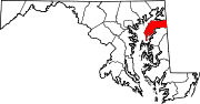
U.S. Highways Roads in Queen Anne's County, Maryland State highways 
U.S. Highways Categories:- State highways in Maryland
- Roads in Cecil County, Maryland
- Roads in Kent County, Maryland
- Roads in Queen Anne's County, Maryland


Wikimedia Foundation. 2010.