- Maryland Route 313
-
Maryland Route 313
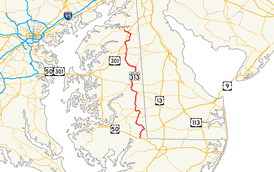
Route information Maintained by MDSHA Length: 75.72 mi[1][2][3][4][5] (121.86 km) Major junctions South end:  US 50 in Mardela Springs
 MD 54 in Mardela Springs
 MD 404 in Denton
 MD 302 in Barclay
 MD 300 in Sudlersville
 US 301 near Massey
 MD 290 near Galena
North end:  MD 213 / MD 290 in Galena
Location Counties: Wicomico, Dorchester, Caroline, Queen Anne's, Kent Highway system Maryland highway system
Interstate • US • State • Minor • Former • Turnpikes←  MD 312
MD 314  →
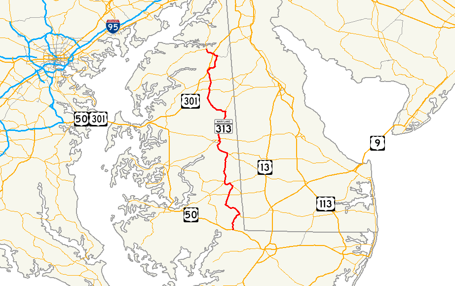
→Maryland Route 313 is a state highway located on the Eastern Shore of Maryland in the United States. The 75.72-mile (121.86 km) route runs from U.S. Route 50 in Mardela Springs, Wicomico County north to Maryland Route 213 and Maryland Route 290 in Galena, Kent County. It is predominantly a rural two-lane road that runs through agricultural areas a short distance west of the Delaware border, with the exception of a four-lane divided bypass of Denton shared with Maryland Route 404. MD 313 serves many communities, including Sharptown, Eldorado, Federalsburg, Denton, Greensboro, Goldsboro, Barclay, Sudlersville, Millington, and Massey. The route intersects many major roads, including Maryland Route 54 in Mardela Springs, Maryland Route 404 in the Denton area, Maryland Route 302 in Barclay, Maryland Route 300 in Sudlersville, and U.S. Route 301 near Massey.
The designation MD 313 was first used prior to 1927 for the road running from Eldorado to Galena, while the portion south to Mardela Springs was designated a part of U.S. Route 213. By 1940, the route was extended to Mardela Springs following a realignment of US 213. A few realignments to MD 313 had occurred by 1960 including one that moved the route to a new road between Federalsburg and Denton. In the 1980s, a four-lane divided bypass of Denton was built and the former alignment of MD 313 in the town became Maryland Route 619. This divided highway was extended further south of Denton in the early 2000s. The remaining two-lane portions of MD 313 that are concurrent with MD 404 are slated to be upgraded to a four-lane divided highway to provide relief to beach traffic along MD 404, a part of the main route between the Chesapeake Bay Bridge and the Delaware beaches.
Contents
Route description
MD 313 runs through rural areas of woods and farms on the Eastern Shore of Maryland, generally a short distance west of the Delaware border. The route heads through five counties in Maryland from south to north: Wicomico, Dorchester, Caroline, Queen Anne's, and Kent. It connects several towns including Mardela Springs and Sharptown in Wicomico County, Eldorado in Dorchester County, Federalsburg, Denton, Greensboro and Goldsboro in Caroline County, Barclay and Sudlersville in Queen Anne's County, and Millington and Galena in Kent County.[6]
Wicomico County
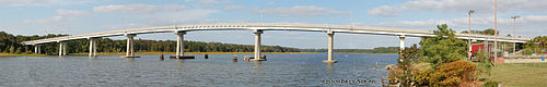 Shaprtown Bridge over the Nanticoke River
Maryland Route 313 begins at an intersection with U.S. Route 50 in Mardela Springs, Wicomico County, where the route heads east past residences along Delmar Road, a 30 mph (48 km/h) two-lane undivided road. A short distance past US 50, the route turns north onto Sharptown Road, with Maryland Route 54 continuing east on Delmar Road toward the Delaware-Maryland state border town of Delmar.[1][6] The route continues north past more residences, with the speed limit increasing to 40 mph (64 km/h) and then to 50 mph (80 km/h) as it leaves Mardela Springs and heads into farmland a short distance west of the Delaware border.[1][6] It continues through a mix of woods and farms with some residences before reaching Sharptown.[6] Here, the road intersects Maryland Route 813F (Twiford Road). MD 313 bypasses Sharptown to the south and intersects Maryland Route 348 (Laurel Road).[1][6] Past this intersection, the route turns north and runs along the eastern edge of the town before crossing over the Nanticoke River.[6]
In Wicomico County, the daily traffic counts on MD 313 range from a high of 4,882 vehicles at the intersection with US 50 in Mardela Springs to a low of 1,552 vehicles at the intersection with MD 54 in Mardela Springs in 2007.[1]
Dorchester County
Upon crossing the Nanticoke River, MD 313 enters Dorchester County and heads northwest through wooded areas before continuing into a mix of woodland and farmland. It turns west before heading northwest again and reaching the town of Eldorado.[2][6] Here, the speed limit drops to 30 mph (48 km/h) and the route intersects the eastern terminus of Maryland Route 14 (Rhodesdale Eldorado Road).[2] At this intersection, MD 313 makes a right turn to head north on Eldorado Road. The route leaves Eldorado and the speed limit increases to 50 mph (80 km/h) again as it continues through farmland with some patches of woods.[2][6] It intersects Maryland Route 392 (Finchville Reliance Road) in Finchville and passes more farming areas with intermittent residences before coming to an intersection with Maryland Route 577 (Reliance Road) on the Caroline County border in Allens Corner.[2][6]
In Dorchester County, the daily traffic counts on MD 313 range from a high of 2,261 vehicles at the intersection with Wheatley Church Road to a low of 1,461 vehicles at the intersection with Dog Kennel Road in 2007.[2]
Caroline County
At the MD 577 intersection, MD 313 runs northwest along the border of Caroline and Dorchester counties as Reliance Road. The speed limit decreases to 35 mph (56 km/h) as the route heads toward the town of Federalsburg, passing through a mix of agricultural and residential areas. The route then leaves the border line and enters Caroline County, intersecting Maryland Route 318 (Federalsburg Highway) and making a left turn to form a concurrency with that route.[3][6] The two routes bypass Federalsburg to the south as a 50 mph (80 km/h) road, crossing over Marshyhope Creek.[3][6] After crossing the creek, the road intersects Maryland Route 308 (South Main Street).[3] The road passes an industrial park before turning north into wooded areas and crossing a Maryland & Delaware Railroad line. After the railroad crossing, MD 313 and MD 318 intersect Maryland Route 307 (Williamsburg Road) at a roundabout located in the southwestern corner of Federalsburg. A short distance later, MD 318 splits from MD 313 by heading west on Preston Road while Maryland Route 315 continues east into Federalsburg on Bloomingdale Avenue.[3][6] Past this intersection, MD 313 continues north on the Federalsburg Highway, leaving the Federalsburg area and heading into a mix of woodland and farmland.[6]

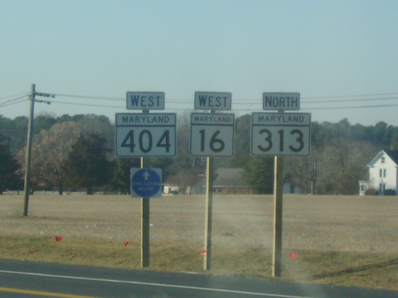
In Andersontown, MD 313 intersects Maryland Route 16 and Maryland Route 404 (Shore Highway), which constitutes a part of the main route between the Chesapeake Bay Bridge and the Delaware beaches.[6][7] Here, the route makes a left turn onto that road, forming a three-route concurrency.[6] At this point, the Shore Highway has a speed limit of 55 mph (89 km/h) and heads northwest through a mix of woods and farms with some homes before widening to a four-lane divided highway. Upon widening into a divided highway, MD 16 splits from MD 313 and MD 404 at an intersection and heads west on Harmony Road. Past this intersection, MD 313 crosses over Watts Creek and heads north through farmland, passing Martinak State Park. The speed limit decreases to 40 mph (64 km/h) as the road heads into commercial areas in the southern part of Denton. The road turns northeast into woods and intersects the eastern terminus of Maryland Route 404 Business (Franklin Street/Gay Street) at an at-grade intersection. Past this intersection, MD 313 and MD 404 become a 55 mph (89 km/h) limited-access road and head north, passing residential neighborhoods and woodland along the eastern side of Denton.[3][6] The road turns to the west and comes to a diamond interchange. Here MD 313 splits from MD 404 by heading north on two-lane undivided Greensboro Road and Maryland Route 619, while the former routing of MD 313 in Denton heads south into Denton on Sixth Street.[6]
The route heads through farmland before passing residences as a 40 mph (64 km/h) road and intersecting the western terminus of Maryland Route 317 (Burrsville Road) in Oil City. Past MD 317, the speed limit increases to 50 mph (80 km/h) and the road continues through mostly wooded areas with some residences and farmland. It reaches the town of Greensboro, where the speed limit drops to 30 mph (48 km/h) and MD 313 intersects Maryland Route 314 (Whiteleysburg Road). The route crosses the Choptank River past MD 314, with the speed limit increasing to 40 mph (64 km/h) and then to 50 mph (80 km/h) before the intersection with the eastern terminus of Maryland Route 480 (Ridgely Road) just north of Greensboro.[3][6] The road continues north through agricultural areas before entering Goldsboro, where the speed limit decreases to 30 mph (48 km/h) and it becomes Old Town Road.[3][6] In Goldsboro, MD 313 intersects Maryland Route 311 (Main Street) and continues through residential areas before coming to an intersection with Maryland Route 287 (Old Line Road). Here, the route makes a left turn to head west on Goldsboro Road. MD 313 leaves Goldsboro and becomes a 50 mph (80 km/h) road that heads into a mix of farmland and woodland. The road intersects unsigned Maryland Route 820 (Castle Hall Road). Past this intersection, MD 313 turns to the northwest and intersects the northern terminus of Maryland Route 312 (Oakland Road) in Baltimore Corner, where it heads north through farm fields past that intersection.[3][6]
In Caroline County, the daily traffic counts on MD 313 range from a high of 15,952 vehicles at the intersection with MD 404 Business along the MD 404 concurrency in Denton to a low of 1,861 vehicles at the intersection with Red Bridges Road between Greensboro and Goldsboro in 2007.[3]
Queen Anne's County
MD 313 crosses Long Marsh Ditch into Queen Anne's County and continues north through more farmland, before intersecting the eastern terminus of Maryland Route 19 (Roberts Station Road) in Ingleside. The route proceeds north, with a traffic count of 2,270 vehicles at the Merrick Corner Road intersection, before reaching the town of Barclay. Here, the road passes residences with a speed limit of 30 mph (48 km/h) and intersects Maryland Route 302 (Church Street). Past this intersection, the road crosses a Maryland & Delaware Railroad line before leaving Barclay and heading back into agricultural areas as a 50 mph (80 km/h) road.[4][6] The Maryland & Delaware Railroad line runs a short distance to the east of MD 313 before eventually running next to the road as it passes through a mix of farms, woods, and residences.[6] The route enters Sudlersville, where the speed limit decreases to 25 mph (40 km/h) and it passes through residential areas in the town on Church Street, with the railroad line drawing farther to the east. In the center of town, the road intersects Maryland Route 300 (Main Street). Past the MD 300 intersection, MD 313 intersects Maryland Route 837 (Church Circle), an unsigned loop to westbound MD 300. Upon leaving Sudlersville, the route becomes 50 mph (80 km/h) Millington Road and heads north through farm fields with intermittent residences.[4][6] MD 313 heads into forested areas as it runs a short distance to the east of U.S. Route 301. It leaves the woodland as it intersects the eastern terminus of Maryland Route 544 (Mcginnis Road).[6] The route heads northeast through a mix of agricultural and residential areas before turning east in a patch of woodland and passing more farm fields and residences.[6] MD 313 turns northeast into wooded residential areas and enters Millington, where it becomes 25 mph (40 km/h) Sassafras Street.[4][6]
In Queen Anne's County, the daily traffic counts on MD 313 range from a high of 2,880 vehicles at the intersection with MD 544 south of Millington to a low of 1,880 vehicles at the intersection with MD 19 in Ingleside in 2007.[4]
Kent County
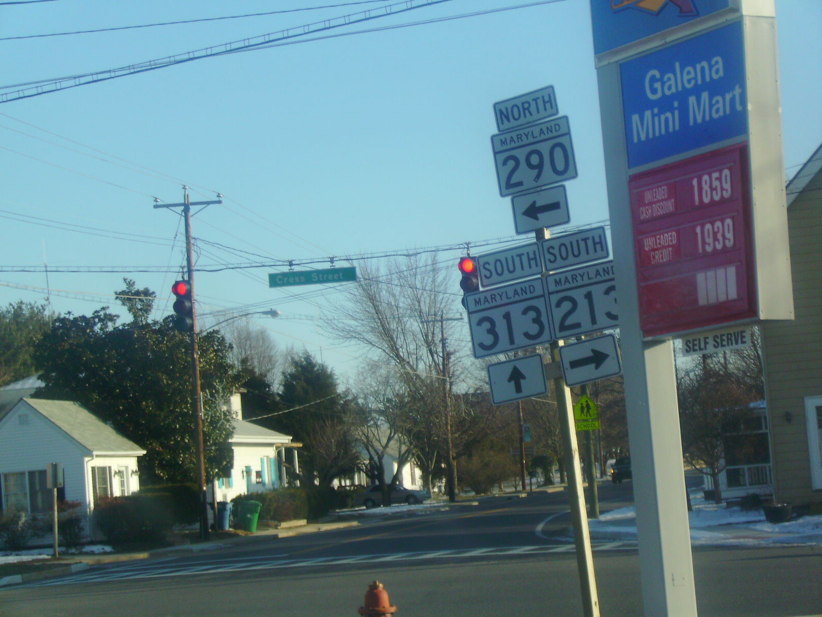
MD 313 crosses the Chester River into Kent County, where it continues north through Millington and crosses Maryland Route 291 (Cypress Street).[5][6] The road passes more residences before leaving Millington and becoming Millington Massey Road, a 50 mph (80 km/h) road that passes by farmland and some residences. MD 313 reaches Massey, where it passes by residences as a 25 mph (40 km/h) road before coming to an intersection at the center of town where it makes a left turn onto Massey Galena Road. It is here that Maryland Route 299 heads north on Massey Road and Maryland Route 330 heads east on Massey Delaware Line Road.[5][6] The route leaves Massey and heads west through farm fields as a 50 mph (80 km/h) road, crossing another Maryland & Delaware Railroad line before heading northwest into forested areas.[5][6] The route intersects the multi-lane, divided U.S. Route 301 (Blue Star Memorial Highway) at a superstreet intersection in which traffic on MD 313 cannot continue directly across US 301 and must use a reversing loop in the median of that route.[6] Past the US 301 intersection, the route officially becomes Maryland Route 313A, but is still signed as Maryland Route 313. It heads west through farmland before turning north and intersecting Maryland Route 290 (Chesterville Road).[5][6] The two routes continue north together into Galena, where the speed limit drops to 25 mph (40 km/h) and the road becomes Main Street.[5][6] It passes residences before intersecting Maryland Route 213 (Main Street) in the center of town where MD 313 ends, MD 290 turns east on Cross Street, and MD 213 goes northbound on Main Street and southbound by going west on Cross Street.[6]
In Kent County, the daily traffic counts on MD 313 range from a high of 3,992 vehicles at the intersection with MD 290 south of Galena to a low of 1,742 vehicles at the intersection with MD 291 in Millington in 2007.[5]
History
The designation MD 313 was in use by 1927 for the road running from Eldorado to Galena, while the current route between Mardela Springs and Eldorado designated as a part of U.S. Route 213, which ran from Ocean City to Elkton.[8] By 1940, US 213 was realigned to follow present-day US 50 between Mardela Springs and Easton, and MD 313 was extended south to end at US 213 in Mardela Springs.[9] By 1960, a few realignments of MD 313 had taken place. The route was moved to its current alignment between Federalsburg and Denton after originally following American Corner Road and MD 16 between the two towns. In addition, the route was rerouted to bypass Greensboro instead of passing through the town on Sunset Avenue (present-day MD 314) and Main Street (present-day MD 480) and a bypass of MD 313 was built east of Ingleside in place of following Roberts Station Road (present-day MD 19) and St. Paul Road.[9][10] In the early 1980s, a four-lane divided bypass of Denton was constructed for MD 313 and MD 404, with the alignment of MD 313 through Denton became MD 619.[11] A superstreet intersection was built at US 301 in 2000, resulting in the northern terminus of MD 313 being officially moved to US 301 and the portion of the route between US 301 and MD 213 being designated MD 313A.[12]Despite this, MD 313A is still signed as MD 313.[6] The divided highway portion of the route in the Denton area was extended further in the 2000s from the south end of Denton to the Sennett Road intersection south of where MD 16 joins the route.[13] This project received $3 million from the federal government in 2001.[14] The remaining two-lane portions of MD 313 that are concurrent with MD 404 are slated to be widened into a four-lane divided highway in order to provide relief to travelers driving to the ocean resorts along MD 404.[15]
Junction list
County Location Mile
[1][2][3][4][5]Destinations Notes Wicomico Mardela Springs 0.00 US 50 (Ocean Gateway) – Cambridge, Salisbury0.12 MD 54 east (Delmar Road) – DelmarSharptown 5.57  MD 813 (Twiford Road)
6.12  MD 348 east (Laurel Road) - Laurel, DE
Dorchester Eldorado 12.25  MD 14 west (Rhodesdale Eldorado Road) – Cambridge
Finchville 15.75  MD 392 (Finchville Reliance Road) – Hurlock, Reliance
Allens Corner 18.93  MD 577 south (Reliance Road) – Reliance, Seaford, DE
Caroline Federalsburg 20.13  MD 318 east (Federalsburg Highway) - Bridgeville, DE
South end of MD 318 overlap 20.64  MD 308 north (South Main Street)
21.86  MD 307 (Williamsburg Road) – Hurlock, Federalsburg
Roundabout 22.32  MD 318 west (Preston Road) / MD 315 south (Bloomingdale Avenue) – Preston, Federalsburg
North end of MD 318 overlap Andersontown 32.22  MD 16 east / MD 404 east (Shore Highway) - Greenwood, DE, Bridgeville, DE
South end of MD 16/MD 404 overlap Denton 34.50 MD 16 west (Harmony Road) – PrestonNorth end of MD 16 overlap 36.69 
 MD 404 Bus. west (Gay Street, Franklin Street)
38.09  MD 404 west (Shore Highway) / MD 619 south (North Sixth Street) – Bay Bridge, Denton
Interchange, north end of MD 404 overlap Oil City 38.86  MD 317 east (Burrsville Road) – Burrsville, Harrington, DE, Milford, DE
Greensboro 44.01 MD 314 (Sunset Avenue/Whiteleysburg Road) – Whiteleysburg, Greensboro44.89  MD 480 west (Ridgely Road) – Greensboro, Ridgely
Goldsboro 48.40  MD 311 north (Main Street) – Marydel
48.83  MD 287 east (Old Line Road) to MD 311 - Camden, DE
50.13  MD 820 east (Castle Hall Road)
Baltimore Corner 52.28 MD 312 south (Oakland Road) – RidgelyQueen Anne's Ingleside 55.01  MD 19 west (Roberts Station Road) – Ingleside, Church Hill
Barclay 58.74 MD 302 (Church Street) to US 301 – Templeville, Dover, DESudlersville 61.77 MD 300 (Main Street) – Church Hill, Chestertown, Dover, DE61.84  MD 837 (Church Circle)
Millington 65.59  MD 544 west (Mcginnis Road) – Chestertown
Kent 68.03  MD 291 (Cypress Street) – Chestertown, Smyrna, DE
Massey 71.74 
 MD 299 north (Massey Road) / MD 330 east (Massey Delaware Line Road) – Sassafras
73.19 US 301 (Blue Star Memorial Highway) – Bay Bridge, WilmingtonSuperstreet intersection, no access across US 301 for MD 313, motorists must use U-turn ramps on US 301 to continue across Galena 75.00 MD 290 south (Chesterville Road) – ChestervilleSouth end of MD 290 overlap 75.72 MD 213 / MD 290 north (Cross Street/Main Street) – Chestertown, Sassafras, CeciltonReferences
- ^ a b c d e f "Highway Location Reference: Wicomico County" (PDF). Maryland State Highway Administration. 2009. http://sha.maryland.gov/Location/2009_WICOMICO.pdf. Retrieved 2010-10-21.
- ^ a b c d e f g "Highway Location Reference: Dorchester County" (PDF). Maryland State Highway Administration. 2009. http://sha.maryland.gov/Location/2009_DORCHESTER.pdf. Retrieved 2010-10-21.
- ^ a b c d e f g h i j k "Highway Location Reference: Caroline County" (PDF). Maryland State Highway Administration. 2009. http://www.marylandroads.com/Location/2009_CAROLINE.pdf. Retrieved 2010-10-21.
- ^ a b c d e f "Highway Location Reference: Queen Anne's County" (PDF). Maryland State Highway Administration. 2009. http://sha.maryland.gov/Location/2009_QUEENANNES.pdf. Retrieved 2010-10-21.
- ^ a b c d e f g h "Highway Location Reference: Kent County" (PDF). Maryland State Highway Administration. 2009. http://sha.maryland.gov/Location/2009_KENT.pdf. Retrieved 2010-10-21.
- ^ a b c d e f g h i j k l m n o p q r s t u v w x y z aa ab ac ad ae af ag ah Google, Inc. Google Maps – overview of Maryland Route 313 (Map). Cartography by Google, Inc. http://maps.google.com/maps?f=d&source=s_d&saddr=US+50+and+Delmar+Road+mardela+springs,+md&daddr=Federalsburg+Bypass%2FMD-313%2FMD-318+to:MD-313%2FOldtown+Rd+to:39.279441,-75.838108+to:MD+213+and+MD+313+galena,+md&geocode=%3BFec-TgIdrql7-w%3BFbKnUwIdRY97-w%3B%3B&hl=en&mra=dpe&mrcr=0&mrsp=3&sz=13&via=1,2,3&sll=39.268012,-75.83725&sspn=0.058741,0.109863&ie=UTF8&ll=38.940185,-75.794678&spn=0.94424,1.757813&t=h&z=9. Retrieved 2009-05-18.
- ^ "Directions from Baltimore to Delaware and Maryland beaches". Beach-Net.com. http://www.beach-net.com/directions/maryland.html. Retrieved 2009-03-25.
- ^ Maryland State Highway Administration (1927). Map of Maryland (Map). http://www.mdhighwaycentennial.com/images/template/gallery/maps/1927SIDE1.jpg. Retrieved 2009-03-03.
- ^ a b Maryland State Highway Administration (1940). Map of Maryland (Map). http://www.mdhighwaycentennial.com/images/template/gallery/maps/1940SIDE1.jpg. Retrieved 2009-03-03.
- ^ Maryland State Highway Administration (1960). Map of Maryland (Map). http://www.mdhighwaycentennial.com/images/template/gallery/maps/1960SIDE1.jpg. Retrieved 2009-03-03.
- ^ "The History of David A. Bramble, Inc". David A. Bramble, Inc.. http://www.davidabrambleinc.com/history.htm. Retrieved 2009-03-27.
- ^ "Highway Location Reference: Kent County" (PDF). Maryland State Highway Administration. 2009. http://sha.maryland.gov/Location/2000_KENT.pdf. Retrieved 2010-10-21.
- ^ "State Highway Administration -- Caroline County -- Line 1 -- Primary Construction Program". Maryland Department of Transportation. http://www.mdot.state.md.us/Planning/Plans%20Programs%20Reports/Programs/CTP%2007-12/Section_H_SHA/Caroline.pdf. Retrieved 2009-03-27.
- ^ "Senators Mikulski and Sarbanes Announce over $100 Million for Key Maryland Transportation Projects". Senator Barbara A. Mikulski. November 30, 2001. http://mikulski.senate.gov/press/01/11/2001C18829.html. Retrieved 2009-03-28.[dead link]
- ^ "Wider Lanes May Improve Beach Traffic". WTOP-FM. July 17, 2007. http://wtop.com/index.php?nid=30&sid=1190456. Retrieved 2009-03-27.
External links
Roads in Caroline County, Maryland State highways 
Roads in Dorchester County, Maryland State highways 
U.S. Highways Roads in Kent County, Maryland State highways 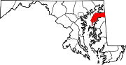
U.S. Highways Roads in Queen Anne's County, Maryland State highways 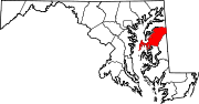
U.S. Highways Roads in Wicomico County, Maryland State highways 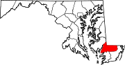
U.S. Highways Categories:- State highways in Maryland
- Roads in Caroline County, Maryland
- Roads in Dorchester County, Maryland
- Roads in Kent County, Maryland
- Roads in Queen Anne's County, Maryland
- Roads in Wicomico County, Maryland


Wikimedia Foundation. 2010.