- Maryland Route 299
-
Maryland Route 299
Route information Maintained by MDSHA Length: 5.67 mi[1][2] (9.12 km) Major junctions South end: 
 MD 313 / MD 330 in Massey
 MD 290 in Sassafras
North end:  US 301 near Warwick
Location Counties: Kent, Cecil Highway system Maryland highway system
Interstate • US • State • Minor • Former • Turnpikes←  MD 298
MD 300  →
→Maryland Route 299 (MD 299) is a state highway in the U.S. state of Maryland. The state highway runs 5.67 miles (9.12 km) from MD 313 and MD 330 in Massey in eastern Kent County north to U.S. Route 301 (US 301) near Warwick in far southern Cecil County. MD 299 was constructed from Massey to the Sassafras River around 1930 and from there to MD 282 in Warwick in the early 1930s. During the 1950s, MD 299 extended to the Delaware state line in Warwick, replacing MD 282. MD 282 was again routed to the state line after MD 299 was rolled back to US 301 in 1959.
Contents
Route description
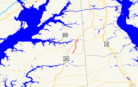
MD 299 begins at a four-way intersection with MD 313 and MD 330 in Massey in eastern Kent County. MD 313 heads west as Galena Massey Road and south as Millington Massey Road. MD 330 heads east as Massey Delaware Line Road. MD 299 heads north as two-lane Massey Road, crossing the Chestertown Branch of the Northern Line of the Maryland and Delaware Railroad just west of the junction of the Centreville and Chestertown branches of the Northern Line. The state highway passes through farmland and crosses Jacobs Creek before an intersection with the northern terminus of MD 290 (Galena Sassafras Road). MD 299 continues northeast as Galena Sassafras Road through a forested area, crossing Herring Creek and passing through the village of Sassafras.[1][3] The state highway crosses the Sassafras River into Cecil County, where the name of the highway changes to Massey Sassafras Road, and reaches its northern terminus at US 301 (Blue Star Memorial Highway). Sassafras Road, which used to be part of MD 299, continues northeast toward the village of Warwick.[2][3]
History
The first section of future MD 299 to be paved was Main Street in Warwick, which was surfaced by 1910.[4] This section was part of a road from Cecilton to the Delaware state line that was completed by 1919 and later designated MD 282.[5][6][7] MD 299 was paved from Massey to the Sassafras River in 1930.[8][9] The modern road was extended north with the completion of a new bridge across the Sassafras River in 1932 and extension of pavement to Main Street in Warwick in 1933.[10][11][12] By 1951, MD 299 replaced MD 282 on Main Street in Warwick.[13] The highway on the Delaware side of the border was changed from Delaware Route 4 to DE 299 to match the Maryland highway number in 1958.[14][15] However, in 1959 MD 299 was rolled back to its present terminus at US 301, which had been extended along the Blue Star Memorial Highway that same year. MD 282 replaced MD 299 in Warwick; MD 299 between US 301 and MD 282 became a county highway.[16]
Junction list
County Location Mile
[1][2]Destinations Notes Kent Massey 0.00 MD 313 (Massey Galena Road/Massey Millington Road) / MD 330 east (Massey Delaware Line Road) – Galena, MillingtonSouthern terminus Sassafras 4.21 MD 290 south (Galena Sassafras Road) – GalenaCecil Warwick 5.67 US 301 (Blue Star Memorial Highway) – Bay Bridge, WilmingtonNorthern terminus; Sassafras Road is former MD 299 Sassafras Road north 1.000 mi = 1.609 km; 1.000 km = 0.621 mi References
- ^ a b c "Highway Location Reference: Kent County" (PDF). Maryland State Highway Administration. 2009. http://www.marylandroads.com/Location/2009_KENT.pdf. Retrieved 2010-10-12.
- ^ a b c "Highway Location Reference: Cecil County" (PDF). Maryland State Highway Administration. 2009. http://www.marylandroads.com/Location/2009_CECIL.pdf. Retrieved 2010-10-12.
- ^ a b Google, Inc. Google Maps – Maryland Route 299 (Map). Cartography by Google, Inc. http://maps.google.com/maps?f=d&source=s_d&saddr=MD-299+N%2FMassey+Rd&daddr=MD-299+N%2FMassey+Rd+to:Sassafrass+Rd&hl=en&geocode=FYDQVwIdMP96-w%3BFcSuWAIdBj17-w%3BFVL2WAIdfWN7-w&mra=ls&sll=39.34705,-75.8125&sspn=0.121863,0.308647&ie=UTF8&t=h&z=12. Retrieved 2010-10-12.
- ^ Maryland Geological Survey. Map of Maryland (Map) (1910 ed.).
- ^ Report of the State Roads Commission of Maryland. 1916-1919. Baltimore: Maryland State Roads Commission. January 1920. p. 44. http://www.archive.org/details/annualreportsofs1916mary. Retrieved 2010-10-12.
- ^ Maryland Geological Survey. Map of Maryland: Showing State Road System and State Aid Roads (Map) (1921 ed.).
- ^ Maryland State Roads Commission. General Highway Map: State of Maryland (Map) (1939 ed.).
- ^ Report of the State Roads Commission of Maryland. 1927-1930. Baltimore: Maryland State Roads Commission. 1930-10-01. p. 218. http://www.archive.org/details/reportofstateroa1927mary. Retrieved 2010-10-12.
- ^ Maryland Geological Survey. Map of Maryland Showing State Road System: State Aid Roads and Improved County Road Connections (Map) (1930 ed.).
- ^ "NBI Structure Number: 100000140016010". National Bridge Inventory. http://nationalbridges.com/nbi_record.php?StateCode=24&struct=100000140016010. Retrieved 2010-10-12.
- ^ Maryland Geological Survey. Map of Maryland Showing State Road System: State Aid Roads and Improved County Road Connections (Map) (1933 ed.).
- ^ Report of the State Roads Commission of Maryland. 1931-1934. Baltimore: Maryland State Roads Commission. 1934-12-28. p. 328. http://www.archive.org/details/reportofstateroa1931mary. Retrieved 2010-10-12.
- ^ United States Geological Survey. Cecilton, MD quadrangle (Map). 1:48,000. 15 Minute Series (Topographic) (1951 ed.). http://historical.mytopo.com/quad.cfm?quadname=Cecilton&state=MD&series=15. Retrieved 2010-10-12.
- ^ Maryland State Roads Commission. Maryland: Official Highway Map (Map) (1958 ed.).
- ^ Delaware Department of Transportation (PDF). Delaware Official Highway Map (Map) (1957/58 ed.). http://www.deldot.gov/archaeology/historic_pres/historic_highway_maps/pdf/cd_030.pdf. Retrieved 2010-10-12.
- ^ Maryland State Roads Commission. Maryland: Official Highway Map (Map) (1959 ed.).
External links
Roads in Cecil County, Maryland State highways 
U.S. Highways Interstate Highways Roads in Kent County, Maryland State highways 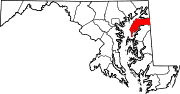
U.S. Highways Categories:- State highways in Maryland
- Roads in Cecil County, Maryland
- Roads in Kent County, Maryland


Wikimedia Foundation. 2010.