- Maryland Route 330
-
Maryland Route 330 Massey Delaware Line Road 
Route information Maintained by MDSHA Length: 3.72 mi[1] (5.99 km) Major junctions West end: 
 MD 313 / MD 299 in Massey
East end: Clayton Delaney Road at the Delaware state line Location Counties: Kent Highway system Maryland highway system
Interstate • US • State • Minor • Former • Turnpikes←  MD 329
MD 331  →
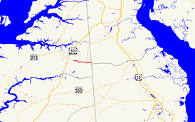
→Maryland Route 330 (MD 330) is a state highway in the U.S. state of Maryland. Known as Massey Delaware Line Road, the state highway runs 3.72 miles (5.99 km) from MD 313 and MD 299 in Massey east to the Delaware state line in eastern Kent County, where the highway continues east as Clayton Delaney Road. MD 330 was constructed in the mid 1950s but was not designated MD 330 until the late 1980s.
Contents
Route description
MD 330 begins at a four-way intersection with MD 313 and MD 299 in Massey. MD 313 northbound heads west as Galena Massey Road and southbound as Millington Massey Road. MD 299 heads north as Massey Road toward Sassafras. MD 330 heads east, crossing the Centreville Branch of the Northern Line of the Maryland and Delaware Railroad just south of the junction of the Centreville and Chestertown branches of the Northern Line. The state highway passes through a mix of farmland and forest, passing the Massey Aerodrome and along the edge of the Millington Wildlife Management Area. MD 330 reaches its eastern terminus at the Delaware state line, where the road continues east as Clayton Delaney Road in the southwest corner of New Castle County.[1][2]
History
The highway from Massey east to the Delaware state line was constructed as a modern road starting in 1954.[3] However, the road remained a county highway until it was designated MD 330 around 1989.[4]
Junction list
The entire route is in Kent County.
Location Mile[1] Intersection Notes Massey 0.00 
 MD 313 (Millington Massey Road/Galena Massey Road) / MD 299 north (Massey Road) – Galena, Millington, Sassafras
Western terminus 3.72 Clayton Delaney Road east Eastern terminus; Delaware state line 1.000 mi = 1.609 km; 1.000 km = 0.621 mi References
- ^ a b c "Highway Location Reference: Kent County" (PDF). Maryland State Highway Administration. 2009. http://www.marylandroads.com/Location/2009_KENT.pdf. Retrieved 2010-10-11.
- ^ Google, Inc. Google Maps – Maryland Route 330 (Map). Cartography by Google, Inc. http://maps.google.com/maps?f=d&source=s_d&saddr=MD-330+E%2FMaryland+Line+Rd&daddr=MD-330+E%2FMaryland+Line+Rd&hl=en&geocode=FYDQVwIdMP96-w%3BFaqwVwId8Px7-w&mra=ls&sll=39.309589,-75.824847&sspn=0.00381,0.009645&ie=UTF8&t=h&z=14. Retrieved 2010-10-11.
- ^ Report of the State Roads Commission of Maryland. 1953-1954. Baltimore: Maryland State Roads Commission. 1954-11-12. p. 151. http://www.archive.org/details/reportofstateroa1953mary. Retrieved 2010-10-11.
- ^ Maryland State Highway Administration. Maryland: Official Highway Map (Map) (1989 ed.).
External links
Roads in Kent County, Maryland State highways 
U.S. Highways Categories:- State highways in Maryland
- Roads in Kent County, Maryland
Wikimedia Foundation. 2010.

