- Maryland Route 329
-
Maryland Route 329
Royal Oak Road 
Route information Maintained by MDSHA Length: 3.29 mi[1] (5.29 km) Major junctions West end:  MD 33 west of Royal Oak
East end: MD 33 east of Royal OakLocation Counties: Talbot Highway system Maryland highway system
Interstate • US • State • Minor • Former • Turnpikes←  MD 328
MD 330  →
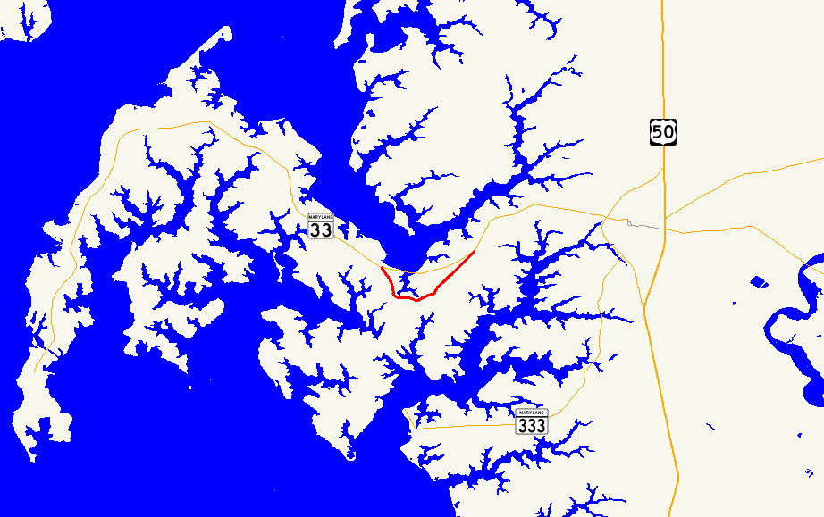
→Maryland Route 329 (MD 329) is a state highway in the U.S. state of Maryland. Known as Royal Oak Road, the state highway runs 3.29 mi (5.29 km) through Royal Oak in western Talbot County, connecting with MD 33 at both termini. MD 329, which formed part of the original road between Easton and Saint Michaels, was constructed as a shell road by the time it was brought under Maryland State Roads Commission maintenance in the mid 1920s.
Contents
Route description
MD 329 begins at an intersection with MD 33 (St. Michaels Road) just west of the village of Newcomb. The two-lane state highway heads south, skirting the southern edge of the community. MD 329 enters the community of Royal Oak, where the highway passes around a branch of Oak Creek and curves to the east. The state highway intersects Bellevue Road, which heads south toward Bellevue and that village's dock of the seasonal Oxford-Bellevue Ferry to Oxford. MD 329 continues east past farmland and scattered residences, heading around the other branch of Oak Creek. After Hopkins Neck Road, the state highway heads straight northeast through a forested area to its eastern terminus at MD 33.[1][2]
History
MD 329 follows the path of the original road between Easton and Saint Michaels, which generally followed present-day MD 33 except for dipping south around the head of Oak Creek and passing through Royal Oak.[3][4] When MD 33 was constructed in the early 1920s, it paralleled the Baltimore, Chesapeake and Atlantic Railway through Newcomb.[3][5] The Maryland State Roads Commission assumed maintenance of the shell road through Royal Oak by 1927.[6][5]
Junction list
The entire route is in Talbot County.
Location Mile[1] Intersection Notes Newcomb 0.00 MD 33 (St. Michaels Road) – St. Michaels, Tilghman IslandWestern terminus Royal Oak 1.01 Bellevue Road south – Bellevue 3.29 MD 33 (St. Michaels Road) – EastonEastern terminus 1.000 mi = 1.609 km; 1.000 km = 0.621 mi References
- ^ a b c "Highway Location Reference: Talbot County" (PDF). Maryland State Highway Administration. 2009. http://www.marylandroads.com/Location/2009_TALBOT.pdf. Retrieved 2010-09-09.
- ^ Google, Inc. Google Maps – Maryland Route 329 (Map). Cartography by Google, Inc. http://maps.google.com/maps?f=d&source=s_d&saddr=MD-329+E%2FRoyal+Oak+Rd&daddr=MD-329+E%2FRoyal+Oak+Rd+to:MD-33+E%2FSt+Michaels+Rd&hl=en&geocode=FQdbTwIdAYN1-w%3BFS4mTwId8MF1-w%3BFdtuTwIdRhF2-w&mra=ls&sll=38.745214,-76.166625&sspn=0.015363,0.038581&ie=UTF8&t=h&z=14. Retrieved 2010-09-09.
- ^ a b United States Geological Survey. Saint Michaels, MD quadrangle (Map). 1:48,000. 15 Minute Series (Topographic) (1904 ed.). http://historical.mytopo.com/quad.cfm?quadname=Saint%20Michaels&state=MD&series=15. Retrieved 2010-09-09.
- ^ United States Geological Survey. Oxford, MD quadrangle (Map). 1:48,000. 15 Minute Series (Topographic) (1904 ed.). http://historical.mytopo.com/quad.cfm?quadname=Oxford&state=MD&series=15. Retrieved 2010-09-09.
- ^ a b Maryland State Roads Commission (JPG). Map of Maryland (Map) (1927 ed.). http://www.mdhighwaycentennial.com/images/template/gallery/maps/1927SIDE1.jpg. Retrieved 2010-09-09.
- ^ Report of the State Roads Commission of Maryland. 1924-1926. Baltimore: Maryland State Roads Commission. January 1927. p. 35. http://www.archive.org/details/annualreportsofs1924mary. Retrieved 2010-09-09.
External links
Roads in Talbot County, Maryland State highways 
U.S. Highways Categories:- State highways in Maryland
- Roads in Talbot County, Maryland


Wikimedia Foundation. 2010.