- Tilghman Island, Maryland
Infobox Settlement
official_name = Tilghman Island, Maryland
settlement_type = CDP
nickname =
motto =
imagesize =
image_caption =
image_
imagesize =
image_caption =
image_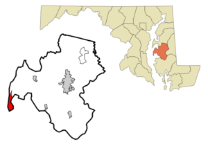
mapsize = 250x200px
map_caption = Location of Tilghman Island, Maryland
mapsize1 =
map_caption1 =subdivision_type = Country
subdivision_name =United States
subdivision_type1 = State
subdivision_name1 =Maryland
subdivision_type2 = County
subdivision_name2 = Talbot
government_footnotes =
government_type =
leader_title =
leader_name =
leader_title1 =
leader_name1 =
established_title =
established_date =unit_pref = Imperial
area_footnotes =area_magnitude =
area_total_km2 = 7.4
area_land_km2 = 7.0
area_water_km2 = 0.4
area_total_sq_mi = 2.8
area_land_sq_mi = 2.7
area_water_sq_mi = 0.1population_as_of = 2000
population_footnotes =
population_total = 854
population_density_km2 = 122.0
population_density_sq_mi = 315.9timezone = Eastern (EST)
utc_offset = -5
timezone_DST = EDT
utc_offset_DST = -4
elevation_footnotes =
elevation_m = 2
elevation_ft = 7
latd = 38 |latm = 42 |lats = 32 |latNS = N
longd = 76 |longm = 20 |longs = 6 |longEW = Wpostal_code_type =
postal_code =
area_code =
blank_name = FIPS code
blank_info = 24-77912
blank1_name = GNIS feature ID
blank1_info = 1852602
website = [http://www.tilghmanisland.com/ www.tilghmanisland.com]
footnotes =Tilghman Island is a
census-designated place (CDP) in Talbot County,Maryland ,United States . The population was 854 at the 2000 census.History
. The island suffered a substantial loss of resources by the British in the War of 1812. In 1890 Steamboat service was established and continued well into the 20th century. Travelers were escorted by horse and ox drawn vehicles to their recreational destinations. The island became—and remains—a popular haven for vacationers who were drawn by superb fishing and genteel accommodations.
Geography
Tilghman Island is located at coor dms|38|42|32|N|76|20|6|W|city (38.708795, -76.335016)GR|1.
According to the
United States Census Bureau , the CDP has a total area of 2.8square mile s (7.4km² ), of which, 2.7 square miles (7.0 km²) of it is land and 0.1 square miles (0.4 km²) of it (4.91%) is water.Demographics
of any race were 0.23% of the population.
There were 368 households out of which 24.7% had children under the age of 18 living with them, 64.9% were married couples living together, 3.8% had a female householder with no husband present, and 28.8% were non-families. 23.9% of all households were made up of individuals and 11.1% had someone living alone who was 65 years of age or older. The average household size was 2.32 and the average family size was 2.72.
In the CDP the population was spread out with 19.2% under the age of 18, 5.3% from 18 to 24, 23.8% from 25 to 44, 29.7% from 45 to 64, and 22.0% who were 65 years of age or older. The median age was 46 years. For every 100 females there were 104.3 males. For every 100 females age 18 and over, there were 100.0 males.
The median income for a household in the CDP was $32,763, and the median income for a family was $38,304. Males had a median income of $21,213 versus $24,286 for females. The
per capita income for the CDP was $13,851. About 8.7% of families and 17.7% of the population were below thepoverty line , including 24.4% of those under age 18 and 8.9% of those age 65 or over.References
External links
* [http://www.tilghmanisland.com/ TilghmanIsland.com]
* [http://www.tilghmanmd.com/ TilghmanMD.com]
Wikimedia Foundation. 2010.