- Maryland Route 333
-
Maryland Route 333
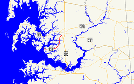
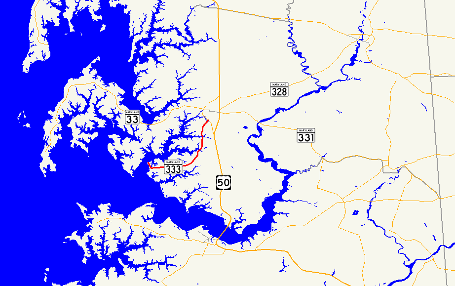
Route information Maintained by MDSHA Length: 9.79 mi[1] (15.76 km) Major junctions South end: Oxford–Bellevue Ferry terminal in Oxford  MD 322 in Easton
North end: Washington Street in Easton Location Counties: Talbot Highway system Maryland highway system
Interstate • US • State • Minor • Former • Turnpikes←  MD 332
MD 334  →
→Maryland Route 333 (MD 333) is a state highway in the U.S. state of Maryland. The state highway runs 9.79 mi (15.76 km) from the terminal of the seasonal Oxford–Bellevue Ferry in Oxford north to Washington Street in Easton within Talbot County. MD 333 was constructed between Trippe Creek and Easton in the 1910s. The highway was extended to Oxford in the late 1920s. In Easton, MD 333 was assigned to the southern part of Washington Street between 1948 and 1959 after U.S. Route 213 (later US 50) bypassed the town.
Contents
Route description
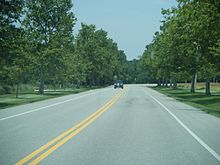 Northbound MD 333 past intersection with Spring Road.
MD 333 begins at the Oxford terminal of the Oxford–Bellevue Ferry along the Tred Avon River. The state highway heads southeast through the town as Morris Street. At the southern end of the town at the head of a branch of Town Creek, Morris Street continues straight as a municipal street while MD 333 curves to the east and leaves the town via Oxford Road.[1][2] The state highway heads east through farmland, beginning a curve to the northeast shortly before Almshouse Road. MD 333 begins to pass residential subdivisions and golf courses as the highway turns north and crosses Trippe Creek and Peach Blossom Creek.[2] North of the latter creek, the state highway enters the town of Easton, then crosses Paper Mill Pond before intersecting MD 322 (Easton Parkway). MD 333 continues northeast as Peach Blossom Road past Easton Middle School to its northern terminus at a five-way intersection with Washington Street, which was formerly part of MD 565, Harrison Street, and Idlewild Avenue.[1][2]
History
The first section of MD 333 was constructed as a state-aid road between Trippe Creek and Peach Blossom Creek in 1913. The state-aid work included bridges over both creeks.[3] The highway was extended as another state-aid project north from Peach Blossom Creek to Easton by 1919.[4] MD 333 was reconstructed as a state highway beginning in 1925. The highway north of Peach Blossom Creek and the portion between Almshouse Road and Trippe Creek were paved or repaved by 1927.[5][6] MD 333 was completed when the highway was completed between Oxford and Almshouse Road by 1930.[7] At the Easton end, MD 333 was extended south on Washington Street to the new eastern bypass of Easton in 1948 when the town was bypassed by US 213, which became US 50 in 1949.[8][9] MD 333's northern terminus was returned to Washington Street when MD 565 was assigned to Washington Street in 1958.[10] The bridges over Peach Blossom Creek and Trippe Creek were replaced in 1997 and 1998, respectively.[11][12]
Junction list
The entire route is in Talbot County.
Location Mile
[1]Destinations Notes Oxford 0.00 Oxford–Bellevue Ferry terminal – Bellevue Southern terminus Easton 9.41  MD 322 (Easton Parkway) to US 50 – Cambridge, Bay Bridge
9.79 Washington Street / Harrison Street north / Idlewild Avenue east Northern terminus; Washington Street is former MD 565 1.000 mi = 1.609 km; 1.000 km = 0.621 mi References
- ^ a b c d "Highway Location Reference: Talbot County" (PDF). Maryland State Highway Administration. 2009. http://www.marylandroads.com/Location/2009_TALBOT.pdf. Retrieved 2010-09-12.
- ^ a b c Google, Inc. Google Maps – Maryland Route 333 (Map). Cartography by Google, Inc. http://maps.google.com/maps?f=d&source=s_d&saddr=Ferry+Crossing+Slip+Rd&daddr=Peachblossom+Rd&hl=en&geocode=FaBpTgIdDKt1-w%3BFfaATwId3DN3-w&mra=ls&sll=38.763863,-76.075988&sspn=0.00384,0.009645&ie=UTF8&t=h&z=12. Retrieved 2010-09-12.
- ^ Report of the State Roads Commission of Maryland. 1912-1915. Baltimore: Maryland State Roads Commission. May 1915. pp. 64–65, 95. http://www.archive.org/details/annualreportsofs1912mary. Retrieved 2010-09-12.
- ^ Report of the State Roads Commission of Maryland. 1916-1919. Baltimore: Maryland State Roads Commission. January 1920. p. 48. http://www.archive.org/details/annualreportsofs1916mary. Retrieved 2010-09-12.
- ^ Report of the State Roads Commission of Maryland. 1924-1926. Baltimore: Maryland State Roads Commission. January 1927. pp. 34, 99. http://www.archive.org/details/annualreportsofs1924mary. Retrieved 2010-09-12.
- ^ Maryland Geological Survey. Map of Maryland: Showing State Road System and State Aid Roads (Map) (1927 ed.).
- ^ Maryland Geological Survey. Map of Maryland Showing State Road System: State Aid Roads and Improved County Road Connections (Map) (1930 ed.).
- ^ Maryland State Roads Commission. Maryland: Official Highway Map (Map) (1948 ed.).
- ^ Maryland State Roads Commission. Maryland: Official Highway Map (Map) (1949 ed.).
- ^ Maryland State Roads Commission. Maryland: Official Highway Map (Map) (1958 ed.).
- ^ "NBI Structure Number: 100000200016010". National Bridge Inventory. http://nationalbridges.com/nbi_record.php?StateCode=24&struct=100000200016010. Retrieved 2010-09-12.
- ^ "NBI Structure Number: 100000200017010". National Bridge Inventory. http://nationalbridges.com/nbi_record.php?StateCode=24&struct=100000200017010. Retrieved 2010-09-12.
External links
Roads in Talbot County, Maryland State highways 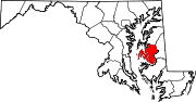
U.S. Highways Categories:- State highways in Maryland
- Roads in Talbot County, Maryland


Wikimedia Foundation. 2010.