- Maryland Route 332
-
Maryland Route 332
Central Avenue, Old Central Avenue 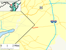
Route information Maintained by MDSHA Length: 1.64 mi[1] (2.64 km) Major junctions West end: Southern Avenue at the Washington, D.C. border East end:  MD 214 in Seat Pleasant
Highway system Maryland highway system
Interstate • US • State • Minor • Former • Turnpikes←  MD 331
MD 333  →
→Maryland Route 332 (MD 332) is a state highway in the U.S. state of Maryland. The route runs 1.07 mi (1.72 km) from Southern Avenue at the Washington, D.C. border east to Maryland Route 214 in Seat Pleasant. MD 332 is the old alignment of MD 214 prior to the latter route's relocation to tie directly into the six-lane East Capitol Street coming out of the District of Columbia.
Contents
Route description
Maryland Route 332 begins as Central Avenue at Southern Avenue at the Washington, D.C. border. Central Avenue continues west until it meets East Capitol Street 0.7 mi (1.1 km) into D.C. The road heads east into densely-populated residential and neighborhood commercial areas of Capital Heights as a two-lane road with a speed limit of 25 mph (40 km/h). MD 332 arrives at an intersection with Chamber Avenue, which heads north toward the Capitol Heights (Washington Metro) station of the Washington Metro, and Larchmont Avenue, which was Maryland Route 200 long before the Intercounty Connector was assigned that number. The road then crosses Capitol Heights Boulevard, where the town hall of Capitol Heights resides. MD 322 next passes Suffolk Avenue, which heads south to Capitol Heights Elementary School, before leaving the town limits of Capitol Heights.
MD 322 next encounters Maryland Park Drive, which was formerly Maryland Route 492. After passing Lyndon Hill Elementary School, unsigned Maryland Route 332A intersects the road and provides full access to Maryland Route 214 (Central Avenue) and the Addison Plaza shopping center 200 ft (61 m) to the north. At this point, MD 332 becomes Old Central Avenue and provides access to a couple of local streets before the state route ends when the eastbound lane merges into MD 214 east.
History
The road on which Maryland Route 332 runs was paved by 1927 and was designated MD 214 by 1939.[2][3] The extension of East Capitol Street out of the District of Columbia was completed in the 1960s. At that time, MD 214 was moved to the new road and MD 332 was assigned to the old alignment.[4] Maryland Route 332A was assigned to the formerly-unnumbered two-way spur to MD 214 in 2008.[1]
Junction list
The entire route is in Prince George's County.
Location Mile[1] Destinations Notes Capitol Heights 0.00 Southern Avenue Central Avenue
Western terminus 0.16 Chamber Avenue / Larchmont Avenue Larchmont Avenue is former MD 200 0.28 Capitol Heights Boulevard 0.48 Suffolk Avenue Seat Pleasant 0.76 Maryland Park Drive Former MD 492 0.94 To MD 214 west (East Capitol Street) – Seat PleasantUnsigned MD 332A 1.07 MD 214 east (Central Avenue) – LargoEastern terminus References
- ^ a b c Maryland State Highway Administration (2008). "Highway Location Reference: Prince George's County" (PDF). http://apps.roads.maryland.gov/KeepingCurrent/performTrafficStudies/dataAndStats/hwyLocationRef/2008_hlr_all/co16.pdf. Retrieved 2010-01-13.
- ^ Maryland State Highway Administration (1927). "Map of Maryland" (JPG). http://www.mdhighwaycentennial.com/images/template/gallery/maps/1927SIDE1.jpg. Retrieved 2010-01-13.
- ^ Maryland State Highway Administration (1939). "Map of Maryland" (PDF). http://commons.wikimedia.org/wiki/File:Maryland_State_Highway_Map_-_1939.pdf. Retrieved 2010-01-13.
- ^ Maryland State Highway Administration (1970). "Map of Maryland" (PDF). http://commons.wikimedia.org/wiki/File:Maryland_State_Highway_Map_-_1970.pdf. Retrieved 2010-01-13.
External links
Roads in Prince George's County, Maryland Maryland State Highways 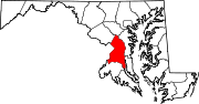
U.S. Routes Interstate Highways Roads by name Categories:- State highways in Maryland
- Roads in Prince George's County, Maryland


Wikimedia Foundation. 2010.