- Maryland Route 564
-
Maryland Route 564

Route information Maintained by MDSHA Length: 6.73 mi[1] (10.83 km) Major junctions West end:  MD 450 in Lanham
 MD 193 in Glenn Dale
East end: Road end in Bowie Highway system Maryland highway system
Interstate • US • State • Minor • Former • Turnpikes←  MD 562
MD 565  →
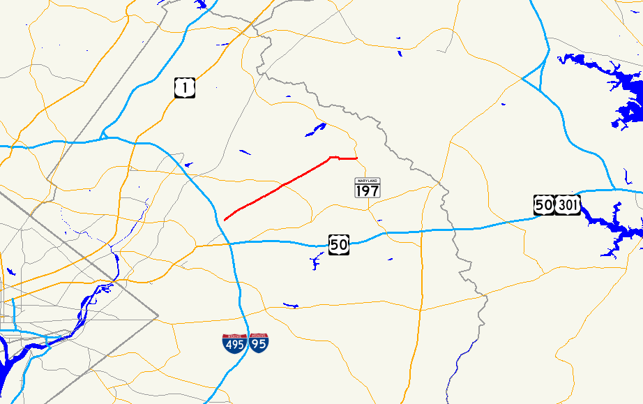
→Maryland Route 564 (MD 564) is a state highway in the U.S. state of Maryland. Known for most of its length as Lanham Severn Road, the state highway runs 6.73 mi (10.83 km) from MD 450 in Lanham east to a dead end near a connection to MD 197 in Bowie.
Contents
Route description
MD 564 begins at a partial interchange with MD 450 (Annapolis Road) in Lanham. There is no access from westbound MD 450 to eastbound MD 564 or from westbound MD 564 to eastbound MD 450. Eastbound MD 564 exits from eastbound MD 450, passes under MD 450, and meets westbound MD 564 at an intersection where heading straight leads to Cipriano Road.[2] The two directions of MD 564 come together as Lanham Severn Road, a two-lane road heading northeast paralleling the Amtrak Northeast Corridor and MARC's Penn Line at a distance. The state highway crosses Baldhill Branch and passes through the unincorporated community of Seabrook, where the road intersects Seabrook Road and passes the Seabrook MARC station.[1][2] After passing through a commercial area in Seabrook, MD 564 passes several industrial properties on the railroad side of the highway.[2] The state highway enters Glenn Dale, where the highway temporarily expands to a four-lane divided highway for intersections with Glenn Dale Road (unsigned MD 953A) and MD 193 (Glenn Dale Boulevard).[1]
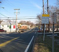
MD 564 continues northeast, passing Hillmeade Road and Springfield Road before entering the city of Bowie, where the highway's name changes to 9th Street.[1] At Chestnut Avenue, which is unsigned MD 564A, the state highway assumes that street's name and turns south to cross the Amtrak Northeast Corridor just north of its junction with CSX's Popes Creek Subdivision. MD 564 turns east onto 11st Street, which heads west toward the railroad wye as unsigned MD 564C. After passing Race Track Road, which heads east toward an intersection with MD 197 (Laurel–Bowie Road), MD 564 curves south and reaches its southern terminus at the entrance to a farm adjacent to the Washington, Baltimore and Annapolis Trail's crossing of MD 197.[1][2]
Junction list
The entire route is in Prince George's County.
Location Mile
[1]Destinations Notes Lanham 0.00 MD 450 (Annapolis Road) – Bladensburg, BowieWestern terminus; partial interchange with no access from westbound MD 450 to eastbound MD 564 0.31 To MD 450 west / Cipriano Road north – GreenbeltU-turn from eastbound MD 564 to westbound MD 564 Glenn Dale 2.93 Glenn Dale Road Old alignment of MD 193; unsigned MD 953A 3.04 MD 193 (Glenn Dale Boulevard) – Greenbelt, KetteringBowie 5.60 Chestnut Avenue north MD 564 turns south onto Chestnut Avenue; unsigned MD 564A; old alignment of MD 197 5.71 11th Street west MD 564 turns east onto 11th Street; unsigned MD 564C 6.35 Race Track Road east to  MD 197
Former MD 703 6.73 Road end Eastern terminus Auxiliary routes
MD 564 has three unsigned auxiliary routes in Bowie.
- MD 564A is the designation for a 0.06-mile (0.097 km) section of Chestnut Avenue that connects MD 564 to the county-maintained portion of the street on the north side of the Amtrak Northeast Corridor.[1][3]
- MD 564B is the designation for Chestnut Street, a 0.04-mile (0.064 km) section of old alignment of MD 197 from MD 564C north to a dead end adjacent to the Huntington Railroad Museum on the south side of the Amtrak Northeast Corridor.[1][4]
- MD 564C is the designation for a 0.02-mile (0.032 km) section of 11th Street that connects the county-maintained portion of Chestnut Avenue with MD 564 on the south side of the Amtrak Northeast Corridor.[1][5]
References
- ^ a b c d e f g h i "Highway Location Reference: Prince George's County" (PDF). Maryland State Highway Administration. 2008. http://apps.roads.maryland.gov/KeepingCurrent/performTrafficStudies/dataAndStats/hwyLocationRef/2008_hlr_all/co16.pdf. Retrieved 2010-06-16.
- ^ a b c d Google, Inc. Google Maps – Maryland Route 564 (Map). Cartography by Google, Inc. http://maps.google.com/maps?f=d&source=s_d&saddr=9th+St%2FLanham+Severn+Rd&daddr=Chestnut+Ave&hl=en&geocode=FR43UwId0nBs-w%3BFZY5UwIdlHJs-w&mra=ls&sll=39.007934,-76.778641&sspn=0.001905,0.004823&ie=UTF8&t=h&z=19. Retrieved 2010-06-16.
- ^ Google, Inc. Google Maps – Maryland Route 564A (Map). Cartography by Google, Inc. http://maps.google.com/maps?f=d&source=s_d&saddr=Old+Marlboro+Pike&daddr=Marlboro+Pike&hl=en&geocode=FYBVUAId6q1s-w%3BFRhoUAId8Bpt-w&mra=ls&sll=38.824137,-76.732668&sspn=0.00382,0.009645&ie=UTF8&t=h&z=15. Retrieved 2010-06-16.
- ^ Google, Inc. Google Maps – Maryland Route 564B (Map). Cartography by Google, Inc. http://maps.google.com/maps?f=d&source=s_d&saddr=11th+St&daddr=11th+St%2FLanham+Severn+Rd&hl=en&geocode=FZoxUwIdK3Ns-w%3BFcQxUwIdznRs-w&mra=ls&sll=39.006763,-76.779126&sspn=0.000953,0.002411&ie=UTF8&t=h&z=20. Retrieved 2010-06-16.
- ^ Google, Inc. Google Maps – Maryland Route 564C (Map). Cartography by Google, Inc. http://maps.google.com/maps?f=d&source=s_d&saddr=Old+Marlboro+Pike&daddr=Marlboro+Pike&hl=en&geocode=FYBVUAId6q1s-w%3BFRhoUAId8Bpt-w&mra=ls&sll=38.824137,-76.732668&sspn=0.00382,0.009645&ie=UTF8&t=h&z=15. Retrieved 2010-06-16.
External links
Roads in Prince George's County, Maryland Maryland State Highways 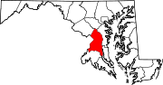
U.S. Routes Interstate Highways Roads by name Categories:- State highways in Maryland
- Roads in Prince George's County, Maryland


Wikimedia Foundation. 2010.