- Maryland Route 565
-
Maryland Route 565
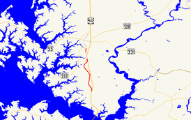
Sections of MD 565 highlighted in red, from south to north: MD 565 and MD 565ARoute information Maintained by MDSHA MD 565 Length: 5.77 mi[1] (9.29 km) South end: Main Street in Trappe North end:  US 50 near Easton
MD 565A Length: 0.58 mi[1] (0.93 km) South end:  MD 322 in Easton
North end: Washington Street in Easton Location Counties: Talbot Highway system Maryland highway system
Interstate • US • State • Minor • Former • Turnpikes←  MD 564
MD 566  →
→Maryland Route 565 (MD 565) is a collection of state highways in the U.S. state of Maryland. These three highways are sections of old alignment of U.S. Route 213, the predecessor route to US 50, between Trappe and Easton. MD 565 runs from Trappe to US 50 south of Easton. MD 565A is a section of Washington Street in the southern part of Easton. MD 565B is an unsigned spur of old alignment near the northern end of MD 565. MD 565 was assigned in the early 1940s when US 213 was moved to a new alignment between Trappe and Peach Blossom Creek in southern Talbot County. MD 565A was designated in the late 1950s in the southern part of Easton and extended north of the downtown area in the mid 1960s. Portions of MD 565 were returned to municipal maintenance in Easton and Trappe in the mid 1980s and late 1990s.
Contents
Route description
MD 565
MD 565 is the designation for Main Street and Easton Trappe Road, a 5.77-mile (9.29 km) section of the old alignment of US 213 on the eastbound side of the federal highway between Trappe and Easton. The state highway begins at the intersection of Main Street and Maple Avenue in the town of Trappe.[1] Main Street, which was once all MD 565, continues south 0.59 miles (0.95 km) as a municipal street to an intersection with US 50.[2] The state highway heads north and its name changes to Easton Trappe Road on leaving the town after passing White Marsh Road.[1] A short distance north of Llandaff Road near the hamlet of Llandaff a short distance south of Peach Blossom Creek, MD 565 turns sharply to the east and reaches its northern terminus at US 50 (Ocean Gateway).[1][2] The old alignment of MD 565, an unnamed 0.14-mile (0.23 km) service road designated MD 565B, continues straight to serve as a driveway for a Honda auto dealership.[1][3] Landing Neck Road continues east on the other side of the federal highway.[2]
MD 565A
MD 565A is the designation for Washington Street, a 0.58-mile (0.93 km) section of the old alignment of US 213 on the eastbound side of the federal highway in Easton. The state highway begins at an intersection with MD 322 (Easton Parkway) a short distance north of MD 322's southern intersection with US 50. After crossing Paper Mill Pond, MD 565A reaches its northern terminus at Lee Terrace. Washington Street, which was once part of a longer MD 565A, continues north as a municipal street into downtown Easton.[1][4]
History
MD 565 was assigned to the old alignment of US 213 between Trappe and Peach Blossom Creek south of Easton by 1946 after US 213 was moved to a new alignment, presently used by US 50, in 1941.[5][6] MD 565A was assigned to Washington Street south of MD 33 in 1958.[7] MD 565A was extended north to Easton Parkway in 1965 when MD 33 was assigned to the northern part of Easton Parkway.[8] The MD 565A designation was removed from Washington Street north of downtown Easton in 1985.[9] The remainder of MD 565A north of Lee Terrace was transferred to the town of Easton in 1999. The portion of Main Street south of MD 565's present southern terminus was transferred to the town of Trappe in 1999.[10]
Junction list
The entire route is in Talbot County.
MD 565
Location Mile
[1]Destinations Notes Trappe 0.00 Main Street south / Maple Avenue Southern terminus of MD 565 5.71 MD 565B north MD 565 turns east at this intersection 5.77 US 50 (Ocean Gateway) – Easton, CambridgeNorthern terminus of MD 565 Landing Neck Road east 1.000 mi = 1.609 km; 1.000 km = 0.621 mi MD 565A
MD 565A is entirely within Easton.
Mile
[1]Destinations Notes 0.00 MD 322 (Easton Parkway) to US 50 – Cambridge, Bay BridgeSouthern terminus of MD 565A 0.58 Washington Street north / Lee Terrace east Northern terminus of MD 565A 1.000 mi = 1.609 km; 1.000 km = 0.621 mi References
- ^ a b c d e f g h i "Highway Location Reference: Talbot County" (PDF). Maryland State Highway Administration. 2009. http://www.marylandroads.com/Location/2009_TALBOT.pdf. Retrieved 2010-09-16.
- ^ a b c Google, Inc. Google Maps – Maryland Route 565 (Map). Google, Inc. http://maps.google.com/maps?f=d&source=s_d&saddr=E+Maple+Ave&daddr=MD-565+N%2FOld+Trappe+Rd&hl=en&geocode=FdjmTQIdJG53-w%3BFWDvTgIdlUx3-w&mra=ls&sll=38.72892,-76.067646&sspn=0.001912,0.004823&ie=UTF8&t=h&z=12. Retrieved 2010-06-09.
- ^ Google, Inc. Google Maps – Maryland Route 565B (Map). Google, Inc. http://maps.google.com/maps?f=d&source=s_d&saddr=MD-565+N%2FOld+Trappe+Rd&daddr=Old+Trappe+Rd&hl=en&geocode=FTzwTgIdMEl3-w%3BFTT4TgIdzkl3-w&mra=ls&sll=38.729797,-76.068456&sspn=0.000956,0.002411&ie=UTF8&t=h&z=17. Retrieved 2010-06-09.
- ^ Google, Inc. Google Maps – Maryland Route 565A (Map). Google, Inc. http://maps.google.com/maps?f=d&source=s_d&saddr=S+Washington+St&daddr=S+Washington+St&hl=en&geocode=FRQ7TwId5j13-w%3BFaRaTwId9D53-w&mra=ls&sll=38.752996,-76.070237&sspn=0.007647,0.01929&ie=UTF8&t=h&z=15. Retrieved 2010-06-09.
- ^ Maryland State Roads Commission. Maryland: Official Highway Map (Map) (1946-47 ed.).
- ^ Report of the State Roads Commission of Maryland. 1939-1940. Baltimore: Maryland State Roads Commission. 1941-03-15. p. 91. http://www.archive.org/details/reportofstateroa1939mary. Retrieved 2010-09-16.
- ^ Maryland State Roads Commission. Maryland: Official Highway Map (Map) (1958 ed.).
- ^ Maryland State Roads Commission. Maryland: Official Highway Map (Map) (1965 ed.).
- ^ Maryland State Highway Administration. Maryland: Official Highway Map (Map) (1985-86 ed.).
- ^ "Highway Location Reference: Talbot County" (PDF). Maryland State Highway Administration. 1999. http://www.marylandroads.com/Location/1999_TALBOT.pdf. Retrieved 2010-09-16.
External links
Roads in Talbot County, Maryland State highways 
U.S. Highways Categories:- State highways in Maryland
- Roads in Talbot County, Maryland


Wikimedia Foundation. 2010.