- Maryland Route 414
-
Maryland Route 414
Oxon Hill Rd, St. Barnabas Rd 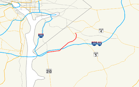
Route information Maintained by MDSHA Length: 5.11 mi[1] (8.22 km) Major junctions West end: Harborview Avenue in Oxon Hill 
 I-95 / I-495
 MD 5
MD 5East end:  MD 458 in Hillcrest Heights
Highway system Maryland highway system
Interstate • US • State • Minor • Former • Turnpikes←  MD 413
MD 418  →
→Maryland Route 414 (MD 414) (Oxon Hill Road west of I-495/I-95 and Saint Barnabas Road east of I-495/I95) is a state road in Prince George's County in the U.S. state of Maryland. It starts at Harborview Avenue just past MD 210's intersection with the Capital Beltway (I-495/I-95) and the Oxon Hill Park and Ride lot near the National Harbor project and terminates at MD 458, going east passing through the communities of Forest Heights, Oxon Hill including the Rivertowne shopping center, Hillcrest Heights, and Suitland.
Contents
Route description
Maryland Route 414 begins along Oxon Hill Road at a point west of National Harbor Road intersection. It begins travelling north, and the route spreads to a four-lane divided orientation before this intersection. It curves to the east after, skirting the Capital Beltway before it meets an interchange with MD 210 (Indian Head Highway). This interchange also provides connections to Interstate 295 further west. MD 414 continues eastbound, losing its median to a shared left-turn lane as it passes through the dense retail area of Oxon Hill. After it crosses John Hanson Lane, the route's name changes to Saint Barnabas Road. It then curves northeast, interchanging with the Capital Beltway itself.
The route continues to serve homes and shopping centers as it passes northeast through Marlow Heights, dualizing once again within the town and widening to six lanes. The route also passes by a number of churches. It curves to the north, narrowing again to four lanes, and meets an interchange with MD 5 (Branch Avenue), continuing north through the residential area. Just beyond its intersection with MD 458 (Silver Hill Road), the route curves sharply west and thins to two undivided lanes, following Old Silver Hill Road and passing through Silver Hill. The route then turns onto Bonita Street and follows it to end the MD 414 designation at another MD 5 intersection.
Junction list
Location Mile Destinations Notes  begins at arbitrary point on Oxon Hill Road
National Harbor 0.08 South Rd. - National Harbor Beltway Parcel northern segment of road connects to exit ramp from 
0.21 North Rd. - National Harbor Beltway Parcel 0.41 Bald Eagle Rd. north - Oxon Hill Farm intersection includes ramps to 
0.52 MD 210 / Indian Head Highway - Indian Head, Washington D.C.grade-separated interchange between routes Oxon Hill 0.73 Felker Ave. 1.03 Livingston Rd. former route of 
1.83 John Hanson Ln. changes to St. Barnabas Rd. at this intersection2.18 I-95/I-495 / Capital Beltway - Richmond, Baltimoregrade-separated interchange between routes 2.39 Virginia Ln. 2.82 Winston St.-Wheeler Rd. Marlow Heights 3.41 Hagan Rd. south 3.72 Temple Hill Rd.-Raleigh Rd. 4.17 Stamp Rd. - to Beech Rd. 4.46 28th Ave. intersection includes ramps to and from 4.57 MD 5 / Branch Avenue - Washington D.C., Waldorf (to  )
)grade-separated interchange between routes 4.81  MD 967A / Bedford Way is unsigned
5.15 MD 458 / Silver Hill Rd. - Suitland (to Suitland Parkway) follows Old Silver Hill Rd. north of this intersection5.61 MD 414A / Old Silver Hill Rd. northformer route of 5.64 MD 5 / Branch Avenuenorthern terminus of References
External links
Roads in Prince George's County, Maryland Maryland State Highways 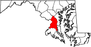
U.S. Routes Interstate Highways Roads by name Accokeek Road • Brandywine Road • Cherry Hill Road • Croom Road • Indian Head Highway • Oxon Hill Road • Piscataway Road • Saint Barnabas Road • Woodyard RoadCategories:- State highways in Maryland
- Roads in Prince George's County, Maryland


Wikimedia Foundation. 2010.