- Randolph Road
-
Maryland Route 927
Montrose Road 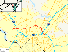
Route information Maintained by MDSHA Highway system Maryland highway system
Interstate • US • State • Minor • Former • Turnpikes←  MD 925
MD 928  →
→Randolph Road is a major cross-county road in Montgomery County, Maryland, and is part of a longer road that runs across Montgomery and Prince George's counties. The full road, which is also known as Montrose Road on the western end and Cherry Hill Road at the southeast, runs between the Potomac and College Park areas. The portion that uses the name "Randolph Road" runs from Rockville to Silver Spring.
The Montrose Road name is used from its west end at Maryland Route 189 (Falls Road) in Potomac to Maryland Route 355 (Rockville Pike) in Rockville. A portion of Montrose road at the interchange with I-270 is designated as Maryland Route 927. The name changes to Randolph Road at Rockville Pike and is known by this name up until US-29, where it changes into Cherry Hill Road. From there, it continues more in a southward direction to its end at US-1 in the College Park area. The road is four to six lanes wide throughout most of its route, and is lined mostly with residential and commercial development.
In the past, a portion of Randolph Road was given the Maryland Route 183 designation from Rockville Pike to New Hampshire Avenue. This was dropped in the 1970s, but is still shown on some maps, including web maps[1].
Contents
Route description
Montrose Road
Montrose Road begins at an intersection with MD 189 (Falls Road) in Potomac. The highway heads east as a two-lane controlled-access highway through a forested corridor between two residential subdivisions. Those neighborhoods are accessed via the only intersection through the corridor with Whites Ford Way. The corridor ends at Seven Locks Road, where Montrose Road expands to a four-lane divided highway. The highway has a partial interchange with the access road to a residential subdivision to the north before its cloverleaf interchange with I-270 (Eisenhower Memorial Highway).[2] Montrose Road is state-maintained and designated MD 927 for 0.45 miles (0.72 km) from the ramp from southbound I-270 to westbound Montrose Road east to the intersection with Tower Oaks Boulevard.[3]
At Tower Oaks Boulevard, Montrose Road expands to six lanes, crosses Cabin John Creek, and passes between residential subdivisions between the city of Rockville to the north and North Bethesda to the south. The highway curves to the southeast at its directional intersection with Montrose Road, where the through highway's name becomes Montrose Parkway. Montrose Parkway continues east with four lanes, crossing over Old Farm Creek and curving back to the east. The highway intersects Jefferson Street before reaching an interchange with MD 355 (Rockville Pike). Access to southbound MD 355 is provided by following Hoya Street north to the interchange ramps, where the eastern end of Montrose Road can be accessed. MD 355 heads south toward the White Flint Metro station. Montrose Parkway passes under MD 355 before intersecting ramps to and from northbound MD 355 adjacent to the Montrose Schoolhouse, which is accessed from the adjacent shopping center.[2]
Randolph Road
Randolph Road begins at the MD 355 interchange in North Bethesda and heads east as a five-lane road with center turn lane. The highway crosses CSX's Metropolitan Subdivision and MARC's Brunswick Line at-grade as the highway passes through a commercial area. Randolph Road intersects Parklawn Drive before passing through a dense suburban residential area. The highway expands to three lanes eastbound at Gaynor Road, gains a median, and gains a third lane westbound immediately after crossing Rock Creek. Randolph Road heads northeast into Wheaton as a six-lane divided highway, where the highway intersects MD 586 (Veirs Mill Road) and MD 185 (Connecticut Avenue) a short distance apart. The highway continues east through a densely-populated suburban area, passing by Wheaton High School and through Denley Park before meeting MD 97 (Georgia Avenue) in Glenmont. MD 97 heads north toward MD 182 (Layhill Road) and the Glenmont Metro station.[4]
Randolph Road continues east, passing John F. Kennedy High School and Glenallan Elementary School before reaching Kemp Mill Road. Kemp Mill Road heads south toward Brookside Gardens and Wheaton Regional Park. Randolph Road continues east, crossing Northwest Branch and passing the historic home Milimar. The highway intersects MD 650 (New Hampshire Avenue) in Colesville. After intersecting Fairland Road, Randolph Road curves to the southeast and becomes a five-lane road with center turn lane. The highway becomes four-lanes with alternating median and undivided sections as it passes through a series of curves and crosses Paint Branch, then returns to five lanes. Randolph Road expands to a divided highway just west of its intersection with Old Columbia Pike, then reaches its eastern terminus at a diamond interchange with US 29 (Columbia Pike) in Fairland.[4] The highway is state-maintained and designated MD 929A for 0.31 miles (0.50 km) from west of Old Columbia Pike—which is itself designated MD 929C for a short distance on either side of the intersection—east to the bridge over US 29.[3]
Cherry Hill Road
Cherry Hill Road begins at the US 29 interchange in Fairland. The highway is state-maintained and designated MD 929B for 0.25 miles (0.40 km) from the bridge over US 29 to east of Prosperity Drive, which is itself designated MD 929D for a short distance south of Cherry Hill Road.[3] Cherry Hill Road transitions from a four-lane divided highway to a four-lane undivided highway as it curves to the southeast through Calverton, where the highway is lined with commercial properties to the south and apartment complexes to the north. The highway enters Prince George's County shortly before reaching an intersection with MD 212 (Powder Mill Road). Cherry Hill Road is five lanes with a center turn lane from the county line to Sellman Road then reduces to two lanes. The highway briefly passes through the United States Department of Agriculture's Beltsville Agricultural Research Center before crossing over the Capital Beltway, which carries both I-95 and I-495, just east of the College Park Interchange. Cherry Hill Road crosses Little Paint Branch and passes by a shopping center before reaching its eastern terminus at US 1 (Baltimore Avenue) in College Park.[5]
Junction list
Montrose Road
Montrose Road is entirely in Montgomery County.
Location Mile
[2]Destinations Notes Potomac 0.0  MD 189 (Falls Road) – Rockville, Great Falls
Western terminus of Montrose Road North Bethesda 1.8  I-270 (Eisenhower Memorial Highway) – Frederick, Washington
I-270 Exit 4; Montrose Road is MD 927 within interchange 2.4 Montrose Road east Roadway continues east as Montrose Parkway 3.4 Hoya Street to  MD 355 south (Rockville Pike) / Montrose Road west – Bethesda
3.6 MD 355 north (Rockville Pike) / Randolph Road east – RockvilleEastern terminus of Montrose Parkway; diamond interchange 1.000 mi = 1.609 km; 1.000 km = 0.621 mi Randolph Road
Randolph Road is entirely in Montgomery County.
Location Mile
[4]Destinations Notes North Bethesda 0.0 MD 355 north (Rockville Pike) / Montrose Parkway west – RockvilleWestern terminus of Randolph Road Wheaton 1.8  MD 586 (Veirs Mill Road) – Rockville, Silver Spring
2.4  MD 185 (Connecticut Avenue) – Kensington, Aspen Hill
Glenmont 3.7  MD 97 (Georgia Avenue) – Wheaton, Olney
Colesville 6.7  MD 650 (New Hampshire Avenue) – White Oak, Cloverly
Fairland 9.1  US 29 (Columbia Pike) / Cherry Hill Road east – Silver Spring, Columbia
Eastern terminus of Randolph Road; Randolph Road is MD 929A within the diamond interchange 1.000 mi = 1.609 km; 1.000 km = 0.621 mi Cherry Hill Road
County Location Mile
[5]Destinations Notes Montgomery Fairland 0.0 US 29 (Columbia Pike) / Randolph Road west – Silver Spring, ColumbiaWestern terminus of Cherry Hill Road; Cherry Hill Road is MD 929B within the diamond interchange Prince George's Calverton 1.9  MD 212 (Powder Mill Road) – Beltsville, Adelphi
College Park 4.1  US 1 (Baltimore Avenue) – Beltsville, Hyattsville, University of Maryland
Eastern terminus of Cherry Hill Road 1.000 mi = 1.609 km; 1.000 km = 0.621 mi Public transportation
Metrorail
Two Washington Metro Red Line stations are located near Randolph Road: White Flint and Glenmont.
Bus
Montrose Road is served by Ride On routes 38 and 81.
Randolph Road is served by Metrobus routes C2, C4, C8, and Ride On routes 10 and 31.
Cherry Hill Road is served by Metrobus routes 81, 83, R2, and R5.
Construction projects
The at-grade intersection of Georgia Avenue (Maryland Route 97) and Randolph Road in Glenmont is currently scheduled to be reconfigured as a grade-separated interchange.[6]
A new roadway to be named the Montrose Parkway will reconfigure a portion of traffic currently handled by Montrose Road and Randolph Road. Its western terminus will be along Montrose Road between I-270 and MD 355, where it will roughly parallel Montrose Road to the south and interchange with MD 355 — replacing the existing intersection of MD 355 with Montrose Road/Randolph Road. To the east, it will continue along a northeasterly alignment and ultimately terminate at MD 586, Veirs Mill Road. The Parkway is being constructed in three phases, with the portion paralleling Montrose Road open to traffic and the two segments to the east of MD 355 now partially open to traffic with the rest of it under construction.[6]
References
- ^ Google Maps
- ^ a b c Google, Inc. Google Maps – Montrose Road (Map). Cartography by Google, Inc. http://maps.google.com/maps?f=d&source=s_d&saddr=Montrose+Rd&daddr=Montrose+Pkwy&hl=en&geocode=FZjzUwId5FVm-w%3BFbrlUwIdvE9n-w&mra=ls&sll=39.054251,-77.127457&sspn=0.015297,0.038581&ie=UTF8&t=h&z=14. Retrieved 2010-11-28.
- ^ a b c "Highway Location Reference: Montgomery County" (PDF). Maryland State Highway Administration. 2009. http://www.marylandroads.com/Location/2009_MONTGOMERY.pdf. Retrieved 2010-11-28.
- ^ a b c Google, Inc. Google Maps – Randolph Road (Map). Cartography by Google, Inc. http://maps.google.com/maps?f=d&source=s_d&saddr=Montrose+Pkwy&daddr=E+Randolph+Rd&hl=en&geocode=FbrlUwIdvE9n-w%3BFWYMVAId2qJp-w&mra=ls&sll=39.070046,-76.950216&sspn=0.030586,0.077162&ie=UTF8&ll=39.053318,-77.022743&spn=0.122374,0.308647&t=h&z=12. Retrieved 2010-11-28.
- ^ a b Google, Inc. Google Maps – Cherry Hill Road (Map). Cartography by Google, Inc. http://maps.google.com/maps?f=d&source=s_d&saddr=Cherry+Hill+Rd&daddr=Cherry+Hill+Rd&hl=en&geocode=FfgLVAIdiKRp-w%3BFbpPUwId5ixq-w&mra=ls&sll=39.022051,-76.926613&sspn=0.030607,0.077162&ie=UTF8&t=h&z=13. Retrieved 2010-11-28.
- ^ a b Montgomery County Consolidated Transportation Plan
External links
Roads in Montgomery County, Maryland Maryland State Highways 
U.S. Routes Interstate Highways Roads by name Cabin John Parkway · Clara Barton Parkway · Cherry Hill Road · Connecticut Avenue · Georgia Avenue · Montrose Road · New Hampshire Avenue · Randolph Road · Sligo Creek Parkway · Wisconsin Avenue · 16th StreetRoads in Prince George's County, Maryland Maryland State Highways 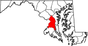
U.S. Routes Interstate Highways Roads by name Accokeek Road • Brandywine Road • Cherry Hill Road • Croom Road • Indian Head Highway • Oxon Hill Road • Piscataway Road • Saint Barnabas Road • Woodyard RoadCategories:- Roads in Montgomery County, Maryland
- State highways in Maryland


Wikimedia Foundation. 2010.