- Maryland Route 185
-
Maryland Route 185
Connecticut Avenue 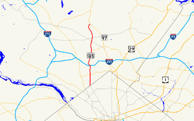
Maryland Route 185 highlighted in redRoute information Maintained by MDSHA Length: 8.30 mi[1] (13.36 km) Major junctions South end: Connecticut Avenue in Washington, D.C.
Randolph Road in Wheaton MD 410 in Chevy Chase
 I-495 in Chevy Chase
 MD 547 in Kensington
 MD 192 in Kensington
 MD 193 in Kensington
 MD 586 in Wheaton
North end:  MD 97 in Aspen Hill
Highway system Maryland highway system
Interstate • US • State • Minor • Former • Turnpikes←  MD 184
MD 186  →
→Maryland Route 185 (MD 185) is a state highway in the U.S. state of Maryland. Known as Connecticut Avenue, the state highway runs 8.30 mi (13.36 km) from Chevy Chase Circle at the Washington, D.C. border north to MD 97 in Aspen Hill. MD 185 serves as a major north-south commuter route in southern Montgomery County, connecting the District of Columbia with the residential suburbs of Chevy Chase, Kensington, and Wheaton.
MD 185's history can be divided into two segments. The portion south of Kensington was included in the state highway system by 1927 as an extension of Connecticut Avenue out of the District of Columbia and was the westernmost stretch of MD 193. The Chevy Chase to Kensington stretch was expanded to a divided highway in the 1950s. The segment of MD 185 between Kensington and Aspen Hill was built as a divided highway on a new alignment in the 1960s and designated MD 185. The MD 185 designation was extended south of Kensington, replacing MD 193, in the 1970s. Construction projects in the 1980s and early 1990s completed MD 185 as a six-lane highway.
Contents
Route description

MD 185 begins at Chevy Chase Circle on the border of Washington, D.C. Connecticut Avenue continues south into the Chevy Chase neighborhood of the District of Columbia on the south side of the circle, while Western Avenue intersects the east and west sides of the circle.[2] MD 185 heads north as a six-lane divided highway with a speed limit of 30 mph (48 km/h) through an affluent residential area in Chevy Chase Village.[1] After passing Chevy Chase Country Club to the west, the state highway intersects MD 191 (Bradley Lane) and leaves Chevy Chase Village.[1] MD 185 continues due north, passing the headquarters of 4-H and intersecting MD 410 (East–West Highway).[2] After crossing MD 410, the speed limit increases to 35 mph (56 km/h) and the state highway passes Columbia Country Club.[1][2] MD 185 enters a commercial area where it crosses the Capital Crescent Trail at-grade and intersects Manor Road. Manor Road fills the missing movements at the following five-way intersection with Jones Bridge Road and Kensington Parkway, where left turns are prohibited from both directions of MD 185 and westbound Jones Bridge Road.[2]
After crossing Jones Bridge Road, MD 185 continues north through residential areas and intersects the Capital Beltway at a partial cloverleaf interchange.[2] Immediately after the interchange, the state highway crosses Rock Creek and intersects Beach Drive within Rock Creek Park.[2] MD 185 leaves the valley of Rock Creek and enters the town of Chevy Chase View.[1] Upon entering Kensington and the Kensington Historic District, the state highway veers to the northwest and back to the north ahead of the intersection with MD 547 (Knowles Avenue), where the highway enters a commercial area.[2] After crossing CSX's Metropolitan Subdivision and MARC's Brunswick Line, MD 185 crosses MD 192 (Plyers Mill Road).[2] As the road turns northeast, the state highway meets MD 193 (University Boulevard). While MD 193 continues northeast toward Wheaton, MD 185 veers left to continue due north. The next intersection, Perry Avenue, is used to complete the movements between MD 185 north and MD 193 east.[2]
After leaving the town limits of Kensington, MD 185 becomes a six-lane controlled access divided highway with a speed limit of 40 mph (64 km/h) passing between residential subdivisions.[1] After crossing a tributary of Rock Creek, the state highway intersects MD 586 at an acute intersection.[2] MD 185 then becomes lined with service roads ahead of and after the intersection with Randolph Road.[2] The speed limit increases to 45 mph (72 km/h) after Randolph Road.[1] Beyond Weller Road, the state highway crosses Turkey Branch and then a bridge over Matthew Henson State Park.[2] MD 185 then enters Aspen Hill and intersects Aspen Hill Road within a commercial area.[2] The state highway meets its northern terminus at MD 97 (Georgia Avenue). Connecticut Avenue continues as a county-maintained highway north through Bel Pre Road into Rossmoor, home of the Leisure World retirement community.[2]
History
MD 185 was constructed and designated on two different segments of the current state highway at different times. The first section to be built was between Chevy Chase and Kensington as an extension of Connecticut Avenue into Montgomery County, which was designated MD 193.[3] The section between Bradley Lane and Kensington was paved by 1927.[4] The segment south of Bradley Lane was paved as a county road by 1930.[5] By 1936, the segment of Connecticut Avenue south of Bradley Lane had come under state control.[6] The grade crossing of the railroad tracks in Kensington was eliminated by the construction of a bypass and bridge in 1936 as well.[7] The section of MD 193 south of MD 410 was marked as an alternate route of US 240 by 1946, a designation it retained until the 1960s.[8][9] The segment from the D.C. line to north of MD 410 in Chevy Chase was expanded to a multi-lane divided highway in 1950.[10] The remainder of the route to Kensington was expanded to a divided highway between 1957 and 1960.[7][11]
The section of highway between Kensington and Aspen Hill was built on a new alignment as a four-lane divided highway in stages in the 1960s and given the designation of MD 185. The highway was completed from Kensington to MD 586 in 1963.[7] The remaining section north to Aspen Hill was completed in 1969.[7][9] Immediately north of the crossing of Turkey Branch is a bridge that was to be MD 185's overpass of the Washington Outer Beltway. Ramp stubs exist next to the bridge for the partial cloverleaf interchange with this cancelled freeway.[2] By 1980, the MD 185 designation was extended south from Kensington south to the D.C. line.[12] The state highway was expanded to six lanes to Beach Drive in 1986 and through Kensington in 1991.[7]
Junction list
The entire route is in Montgomery County.
Location Mile
[1]Destinations Notes Chevy Chase Village 0.00 Connecticut Avenue south / Western Avenue – Washington Southern terminus 0.60  MD 191 west (Bradley Lane) – Bethesda
Chevy Chase 1.38 MD 410 (East–West Highway) – Bethesda, Silver Spring2.22 Jones Bridge Road / Kensington Parkway – Bethesda, North Chevy Chase No left turns from MD 185; use Manor Road 2.62 I-495 (Capital Beltway) – Silver Spring, Baltimore, Frederick, Northern VirginiaI-495 Interchange 33 2.83 Beach Drive – North Bethesda Kensington 4.24 MD 547 west (Knowles Avenue) – Garrett Park4.40 MD 192 (Plyers Mill Road) – Forest Glen4.54 MD 193 west (University Boulevard) – WheatonWheaton 5.92 MD 586 (Veirs Mill Road) – Rockville, Wheaton6.32 Randolph Road – Rockville, Glenmont Aspen Hill 8.30 MD 97 (Georgia Avenue) – Wheaton, OlneyNorthern terminus References
- ^ a b c d e f g h "Highway Location Reference: Montgomery County" (PDF). Maryland State Highway Administration. 2008. http://apps.roads.maryland.gov/KeepingCurrent/performTrafficStudies/dataAndStats/hwyLocationRef/2008_hlr_all/co15.pdf. Retrieved 2010-02-11.
- ^ a b c d e f g h i j k l m n o Google, Inc. Google Maps – Maryland Route 185 (Map). Cartography by Google, Inc. http://maps.google.com/maps?f=d&source=s_d&saddr=md-185+and+chevy+chase+circle+chevy+chase,+md&daddr=md-185+and+md-97+aspen+hill,+md&geocode=Fd-aUgIdU-Zn-ykzUaWcocm3iTFrQybptzqCoQ%3BFZpeVAIddOJn-ynLUo8TPc63iTFX4TMv2tMhYg&hl=en&mra=ls&sll=39.024128,-77.078793&sspn=0.121891,0.308647&ie=UTF8&ll=39.025852,-77.076988&spn=0.121888,0.308647&t=h&z=12. Retrieved 2010-02-12.
- ^ Maryland State Roads Commission (PDF). Map of Maryland (Map) (1939 ed.). http://commons.wikimedia.org/wiki/File:Maryland_State_Highway_Map_-_1939.pdf. Retrieved 2010-02-12.
- ^ Maryland State Highway Administration (JPG). Map of Maryland (Map) (1927 ed.). http://www.mdhighwaycentennial.com/images/template/gallery/maps/1927SIDE1.jpg. Retrieved 2010-02-12.
- ^ Maryland State Roads Commission (JPG). Map of Maryland (Map) (1930 ed.). http://commons.wikimedia.org/wiki/File:Maryland_State_Highway_Map_-_1930.jpg. Retrieved 2010-02-12.
- ^ Maryland State Roads Commission (PDF). Map of Maryland (Map) (1936 ed.). http://commons.wikimedia.org/wiki/File:Maryland_State_Highway_Map_-_1936.pdf. Retrieved 2010-02-12.
- ^ a b c d e Svirsky, Alexander. "National Bridge Inventory Database". http://nationalbridges.com/. Retrieved 2010-02-12.
- ^ Maryland State Roads Commission (PDF). Map of Maryland (Map) (1946 ed.). http://commons.wikimedia.org/wiki/File:Maryland_State_Highway_Map_-_1946.pdf. Retrieved 2010-02-12.
- ^ a b Maryland State Roads Commission (PDF). Map of Maryland (Map) (1970 ed.). http://commons.wikimedia.org/wiki/File:Maryland_State_Highway_Map_-_1970.pdf. Retrieved 2010-02-12.
- ^ Maryland State Roads Commission (PDF). Map of Maryland (Map) (1950 ed.). http://commons.wikimedia.org/wiki/File:Maryland_State_Highway_Map_-_1950.pdf. Retrieved 2010-02-12.
- ^ Maryland State Roads Commission (PDF). Map of Maryland (Map) (1960 ed.). http://commons.wikimedia.org/wiki/File:Maryland_State_Highway_Map_-_1960.pdf. Retrieved 2010-02-12.
- ^ Maryland State Highway Administration (PDF). Map of Maryland (Map) (1980 ed.). http://commons.wikimedia.org/wiki/File:Maryland_State_Highway_Map_-_1980.pdf. Retrieved 2010-02-12.
External links
Roads in Montgomery County, Maryland Maryland State Highways 
U.S. Routes Interstate Highways Roads by name Cabin John Parkway · Clara Barton Parkway · Cherry Hill Road · Connecticut Avenue · Georgia Avenue · Montrose Road · New Hampshire Avenue · Randolph Road · Sligo Creek Parkway · Wisconsin Avenue · 16th StreetCategories:- State highways in Maryland
- Roads in Montgomery County, Maryland


Wikimedia Foundation. 2010.