- Partial cloverleaf interchange
-
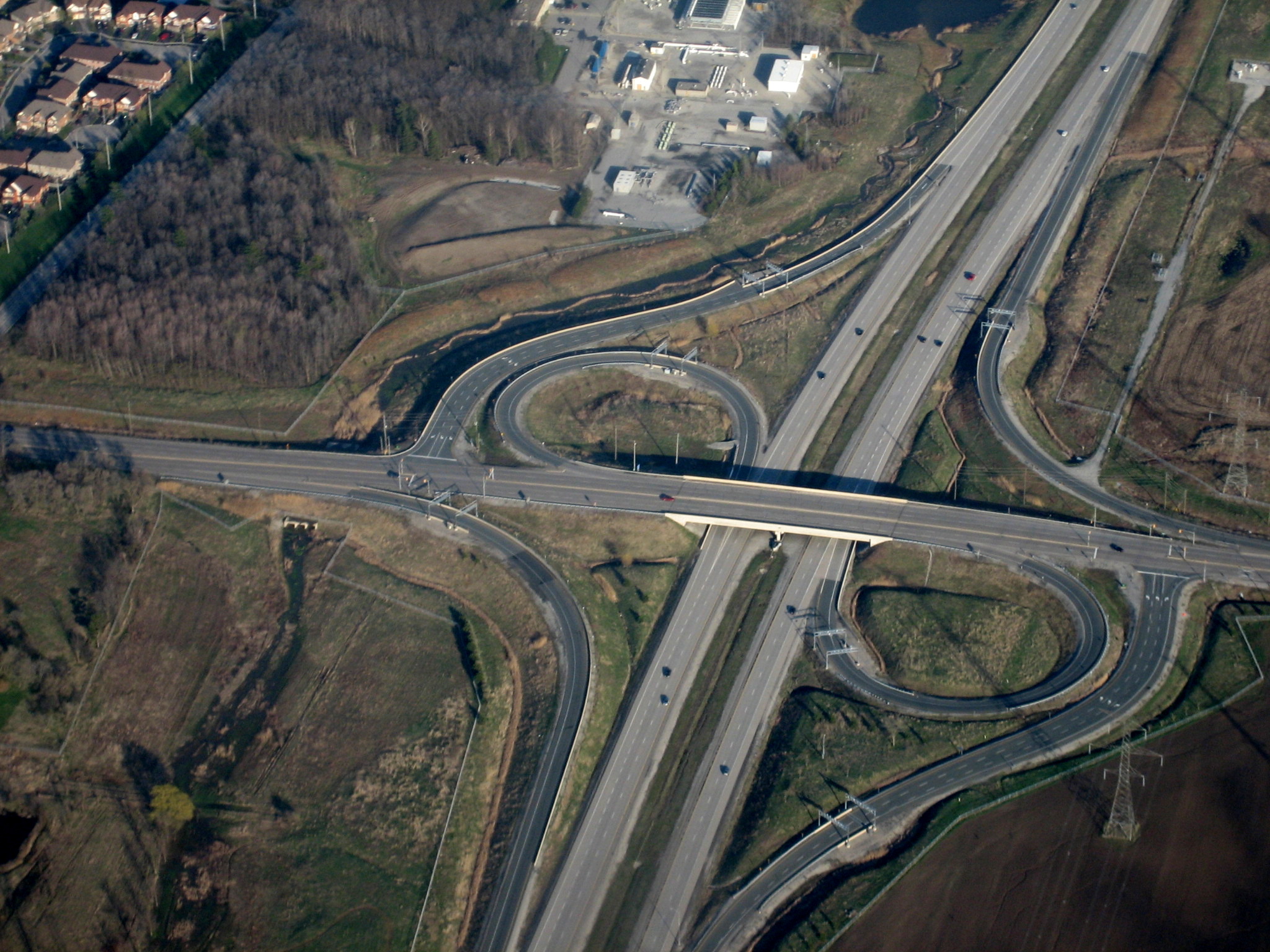
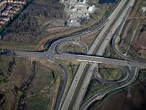 A Parclo A-4 type interchange on the Highway 407 Electronic Toll Route in Ontario
A partial cloverleaf interchange or parclo is a modification of a cloverleaf interchange. The parclo interchange was developed by the Ontario Ministry of Transportation[citation needed] as a replacement for the cloverleaf on 400-Series Highways, removing the dangerous weaving patterns and allowing for more acceleration and deceleration space on the freeway. The design has been well received, and has since become one of the most popular freeway-to-arterial interchange designs in North America. It has also been used occasionally in some European countries, such as Germany and the Netherlands.
Contents
Relationship with other interchanges
A diamond interchange has four ramps. A cloverleaf interchange has eight ramps, as does a stack interchange. A parclo is then somewhere in between, although six is the most common.
Naming
In Ontario, the specific variation is identified by a letter/number suffix after the name. Other jurisdictions do not have naming conventions, so Ontario's naming conventions are used in this article. The letter A designates that two ramps meet the freeway before the driver crosses the arterial road, while B designates that two ramps meet the freeway past the crossing. The number designates how many quadrants of the interchange contain ramps. In left-hand drive countries, the ramps function the same as in right-hand drive countries, but ramps with the same appear visually reversed. Common parclo configurations include the Parclo A2, Parclo B2 and Parclo A4.
Configurations
A2 and B2
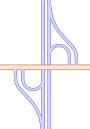 Parclo B2 Interchange (folded diamond)
Parclo A2 and B2 configurations contain four ramps. On each side of the freeway there is a loop ramp and a directional ramp. In Parclo A2, the loop ramps serve as on-ramps and the directional ramps serve as off-ramps. In Parclo B2 the roles are reversed. both on- and off-ramps require require controlled intersections at the arterial road (sometimes loop and directional ramps from the same side of the freeway will utilize the same intersection). The Parclo A2 and B2 are commonly used on rural freeways such as Highway 402 and Highway 416, where the ramps can be added without widening the street overpass/underpass to include deceleration lanes (normally needed on the A4 in order to safely enter the loop ramps that lead to the freeway). The Parclo A2 and B2 ramps are also usually longer and allow for higher speeds than their A4 counterparts because of rural land availability. It is possible to upgrade an A2 to an A4 by adding directional ramps, serving arterial-to-freeway traffic that would otherwise be forced to make a left turn to enter the loop ramps.
A4
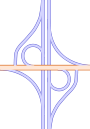 Parclo A4 Interchange
The Parclo A-4 contains 6 ramps. On each side on the freeway, there is an (often multi-lane) exit ramp, followed by a loop ramp and directional ramp entering the freeway. The on-ramps are in the same configuration as a cloverleaf interchange, but there is one off-ramp for each freeway direction instead of two, typically requiring a controlled intersection where the off-ramp meets the arterial road. The Parclo A4 is one of the most popular designs, as all movements from the arterial road to the entrance ramps are made by right-hand turns, providing for a safer entrance to the freeway by eliminating left-hand turns into opposing traffic (which require queues waiting to make such turns). This also makes logical sense since freeways have a higher capacity than arterials and right-turn ramps serve effectively to absorb capacity and reduce traffic on the arterial. Some parclos have the right-turning (directional) on-ramp leave the arterial road after the exit ramp intersection. This configuration is often used when another road meets the freeway off-ramp and gives traffic from this road the option of turning right to use the directional on-ramp to enter the freeway.
Traffic exiting the freeway to the arterial road is provided with a long, relatively straight exit ramp, preventing most speed-related rollovers. These exit ramps are also frequently multi-laned to accommodate traffic turning left, right, or going straight ahead in some cases. Traffic signals are commonly installed at the end of the exit ramp to regulate the freeway traffic flowing onto the arterial.
The Parclo A4 is particularly well-suited to suburban areas with high traffic levels; Ontario freeways built in the Greater Toronto Area since the 1970s such as Highway 403, Highway 404, and Highway 410 use this design at almost all individual junctions except where land conditions do not permit it. The first freeway constructed in the GTA thirty years later, Highway 407, still retains the Parclo A4 interchanges wherever possible.
Caltrans favors this form for some recent projects, for example the reconstruction of I-880. They often replaced previous full cloverleafs. All exiting traffic for both directions has a relatively straight ramp and is controlled by a traffic light. Running off the road on an entering ramp is much less likely than on an exiting ramp. Metering lights are a common feature on the entering ramps.
B4
The Parclo B4 interchange superficially appears to be a mirror image of the Parclo A4. However, the B4 design provides freeway-to-arterial ramps without traffic lights, while traffic turning left from the arterial must cross opposing traffic. Although this design has the potential to flood the arterial with more freeway traffic than the Parclo A4, one particular advantage is the ability to coordinate the traffic signals on the arterial in both directions independently. This is useful when there is more through-movement traffic on the arterial than turning traffic.
The Parclo B4 is less common in Ontario than the Parclo A4, with the only examples being the following:
- Highway 402/Highway 40 interchange in Sarnia
- the interchange at Lauzon Parkway and the E. C. Row Expressway in Windsor
- Highway 17/Municipal Road 55 interchange in Sudbury
- Highway 406/St. David's Road interchange on the border of St. Catharines and Thorold
- Highway 400 and Dunlop street in Barrie (but this interchange is mandatory due to the angle the 2 roads meet at)
Three exist in British Columbia. In addition, the Solomon Pond Road interchange on I-290 in Northborough, Massachusetts was converted from a B2 interchange to a B4 interchange in the mid-1990s with the construction of the Solomon Pond Mall. The US 83 interchange on I-80 in North Platte, Nebraska has also recently been upgraded to a B4 from a diamond.
At least three B4 designs are known to exist in Kentucky:
- The Taylorsville Road interchange with the Watterson Expressway in Louisville. The B4 design was necessary in this case because of the angle at which Taylorsville Road crosses the Watterson.
- The US 127 interchange with Interstate 64 in Frankfort.
- US 127 has a second B4 interchange at the Bluegrass Parkway near Lawrenceburg, about 15 miles (24 km) south of the I-64 crossing. This particular interchange is a conversion from a four-loop design at the location of one of the toll booths on the Bluegrass Parkway before its conversion into a freeway. Toll booths were located directly below US 127; through traffic used the through lanes, while both entering and exiting traffic shared a lane directly to the right of the through lanes. The old design was standard for interchanges at toll booths in Kentucky's parkway system of controlled-access toll roads; even though tolls have been removed from all of the roads, many of the old designs still exist at former toll booth sites.
A Parclo B4 in south Calgary is subject to the traffic flooding problem on a daily basis. Traffic coming off the Macleod Trail freeway overwhelms Anderson Road, resulting significant delays and frequent accidents. The style of intersection was made necessary due to the presence of a small private cemetery in one quadrant of the interchange: under the Cemetery Act of Alberta, cemeteries may not be moved or developed under any circumstance.
Some Parclo B4 interchanges such as the intersection of Interstate 40 and U.S. Route 401 in Raleigh have been fitted with signals at each ramp meeting the arterial in order to allow more lanes on the offramps. This technique along with the ability to provide two-way signal progression along the arterial allows the Parclo B4 to handle an extremely high flow of traffic along the arterial.
Other variations
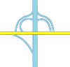 Parclo AB3 Interchange (hybrid)
Parclo designs with only two quadrants are commonly referred to as folded diamonds, due to their similarity with diamond interchanges. Sometimes the ramps in a folded diamond are actually local streets; surface roads upgraded to higher standards often do this to save money on land acquisition. This type of interchange long predates the Parclo; the Merritt Parkway and Queen Elizabeth Way, both built in the 1930s, used mainly folded diamonds and cloverleaves. Another example of this is Highway 401's interchange with Highway 2 east of Tilbury (Exit 63): the ramps also have intersections fairly close to the freeway to allow traffic to continue on a rural country road (Jeannette's Creak Road / McKinlay Road) which formerly met Highway 2. [1]
Depending on traffic and land needs, hybrid designs, such as the Parclo AB and Parclo A3, can be created. Other variants, not describable using Ontario's system, eliminate one or more outside ramps, while leaving the loop ramps in those quadrants. In the United States, folded diamonds are frequently used in interchanges with roads that have a railroad line closely paralleling the surface street; entrance/exit ramps are not permitted to have level crossings in modern American practice.
 Parclo at Saskatchewan Highway 1 (the Trans Canada Highway (east-west), Saskatchewan Highway 39 and Saskatchewan Highway 301.
The parclo interchange at Ontario Highway 407 and Britannia Road West, west of Toronto, is the same as used at the junction of Saskatchewan Highway 1 (the Trans Canada Highway (east-west), Saskatchewan Highway 39 (south, part of the CanAm route) and Saskatchewan Highway 301 (north). It is a junction which is half cloverleaf, half diamond.[1]
Freeway-to-freeway interchanges
In the late 1960s, there were parclo designs modified for freeway traffic. The ramps are longer to allow for higher speeds, particularly the loop ramp radii, which are enlarged to allow a recommended 40 km/h (25 mph) instead of 30 km/h (19 mph). In a right-hand traffic (RHT) system, the signalized left turn is eliminated by an underpass or overpass.
Examples include the Highway 401-404 junction, and the former interchange between I-635 and US 75, the latter which has since been replaced by a five-level stack.[2][3]
Clover-stack
 Cloverstack
More recently, there has been the cloverleaf-stack or clover-stack (also known as a partial stack or hybrid parclo/stack) which is a three level freeway-to-freeway interchange which mostly resembles the Parclo A4, but adds third-level flyover ramps to eliminate the need for signalized left turns (in a right-hand traffic (RHT) system). Though having lower capacity than a four-level stack interchange, particularly due to the loop ramps, clover-stacks can be constructed significantly cheaper and also require less land. Alternatively, clover-stacks are formerly cloverleaf interchanges with two loop ramps (typically diagonal from each other) replaced with flyover ramps. Examples of clover-stacks include the Highway 407 interchanges with Highways 410 and Highway 404 in Toronto, and the Interstate 79 interchange with Interstate 376 in Pittsburgh.
The Highway 401-Allen Road interchange is a hybrid of the turbine and clover-stack, with some ramps dedicated to serving the adjacent Yorkdale Mall rather than freeway to freeway traffic. The turbine/whirlpool requires fewer levels while retaining semi-directional ramps throughout and has the left-turning ramps sweep around the center of the interchange in a spiral pattern. This has slightly less capacity because the ramps turn and change height more quickly.
Implementation
In California, Caltrans currently has a policy[citation needed] that whenever cloverleaf interchanges between freeways and surface streets are being rebuilt to handle higher traffic loads, they are turned into parclo interchanges by removing some of the loop ramps (or in rare cases bridges will be added between adjacent loop ramps — see cloverleaf interchange for details). However, as for cloverleaf interchanges between freeways, they are being unwound into partial stack interchanges or made safer with slip ramps as funds permit. Ontario has a similar policy, having upgraded many full cloverleaf interchanges to six-ramp parclos in the 1990s.[citation needed]
Various forms of parclo interchanges are used on the North Luzon Expressway in the Philippines. The configuration of parclo interchanges (particularly those of the "folded diamond" type) allows for the consolidation of toll barriers at points where onramps and offramps run alongside each other. A single large barrier can serve each onramp/offramp pair simultaneously, reducing construction and operation expenses.
References
- ^ Dan Dan the Man. "The Cloverleaf Interchange". http://whereroadsmeet.8k.com/article/clover.htm. Retrieved 2008-04-24..
Roads and junctions Types of road By countryGermany · Croatia · Spain · Italy · Portugal · Czech Republic · Ireland · United States (U.S. Routes · Interstates)Main roadsArterial road · Collector road · Express-collector setup · Farm-to-market road · Highway · Link road · Two-lane expressway · 2+1 road (Parkway · Super two · 2+2 road) · Trunk road · Highway systems by countryLocal roadsBoulevard · Frontage road · Road · Single carriageway · Street · Alley · Backroad · Cul-de-sac · Driveway · Lane · Primitive road · Side roadOther termsSurfaces Asphalt concrete · Brick · Chipseal · Cobblestone · Concrete · Corduroy · Dirt · Gravel · Ice · Macadam · Oiled (bitumen) · Plank · Sett · TarmacRoad junctions Cloverleaf · Diamond · Directional T · Diverging diamond · Parclo · Trumpet · SPUI · Stack · Three-level diamond · Raindrop · Roundabout interchangeRaised pavement marker · List of road types by features · Central reservation · Sidewalk · Lane Categories:- Road junction types
- Roads in Ontario
- Canadian inventions


![[3]](http://tti.tamu.edu/publications/researcher/v40n2/images/high5before.jpg)
Wikimedia Foundation. 2010.