- Michigan left
-
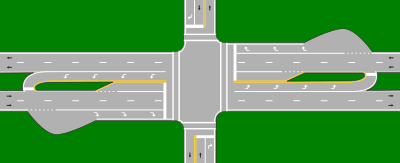
 Stylized depiction of the design in Grand Haven, Michigan, at US 31 and Robbins Road (north to the right), showing the additional area necessary to make a turn on a narrow median. 43°2′40.18″N 86°13′12.57″W / 43.0444944°N 86.2201583°W
A Michigan left is an at-grade intersection design which replaces each left turn with a permutation of a U-turn and a right turn. The design was given the name due to its frequent use along Michigan roads and highways since the late 1960s.[1] In other contexts, the intersection is called a median U-turn crossover or median U-turn.[2][3] The design is also sometimes referred to as a boulevard turnaround[4] or a thru turn intersection.[5]
Contents
Description
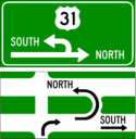
The design occurs at intersections where at least one road is a divided highway or boulevard, and left turns onto—and usually from—the divided highway are prohibited. In almost every case, the divided highway is multi-laned in both directions. When on the secondary road, drivers are directed to turn right. Within 1⁄4 miles (400 m), they queue into a designated U-turn (or cross-over) lane in the median. When traffic clears they complete the U-turn and go back through the intersection. Additionally, the U-turn lane is designed for one-way traffic. Similarly, traffic on the divided highway cannot turn left at an intersection with a cross street. Instead, drivers are instructed to "overshoot" the intersection, go through the U-turn lane, come back to the intersection from the opposite direction, and turn right.
When vehicles enter the cross-over area, unless markings on the ground indicate two turning lanes in the cross-over, drivers form one lane. A cross-over with two lanes is designed at high-volume cross-overs, or when the right lane turns onto an intersecting street. In this case, the right lane is reserved for vehicles completing the design. Most cross overs must be made large enough for semi-trailer trucks to complete the cross over. This large cross-over area often leads to two vehicles incorrectly lining up at a single cross-over.
Locations
 A typical Michigan left layout: Telegraph Road (US 24) at Warren Road near Detroit, showing Michigan lefts 42°20′28″N 83°16′23″W / 42.341°N 83.273°W
The Michigan Department of Transportation first used the design at the intersection of 8 Mile Road (M-102) and Livernois Avenue (42°26′46″N 83°08′28″W / 42.4461°N 83.141°W)[6] in Detroit in the early 1960s. The increase in traffic flow and reduction in accidents was so dramatic that over 700 similar intersections have been deployed throughout the state since then.
In 2009 the Victorian state government in Australia announced the introduction of a "P-turn", similar to the Michigan left, in the southern Melbourne suburb of Frankston.[7] Traffic in Australia drives on the left: the P-turn requires right-turning vehicles to turn left then make a U-turn.
The design has been proposed in Toronto to relieve motorists who wish to make a left-turn on roadways which will contain a proposed streetcar line by the Transit City project.
In Mexico, Guadalajara has a grade-separated variation of this setup in the intersection of Mariano Otero Avenue and Manuel Gómez Morín Beltway (20°37′50″N 103°26′06″W / 20.630666°N 103.434981°W).[8] Traffic flowing through Mariano Otero is routed through an overpass above the beltway, with two access roads allowing right turn on all four possible directions; the U-turns, meanwhile, are built underneath the beltway and allow the left turn from Mariano Otero avenue to the beltway.
Brazil is also known to utilize this setup especially in Sao Paulo.
The city of Plano was the first city in Texas to use a Michigan left. One was built in mid-2010 at the intersection of Preston Road and Legacy Drive.[9]
The city of Draper, a suburb of Salt Lake City, Utah, announced in 2011 that it would be building Utah's first "Thru-Turn" at the intersection of 12300 South and State Street, just off Interstate 15 through Salt Lake County. Construction is scheduled to begin in summer 2011 and be operational by Jan 1, 2012.[5]
Applicable traffic studies
This type of intersection configuration, as with any engineered solution to a traffic problem, carries with it certain advantages and disadvantages and has been subject to several studies.
Studies have shown a major reduction in left-turn collisions and a minor reduction in merging and diverging collisions, due to the shifting of left turns outside the main intersection.[3] In addition it reduces the number of different traffic light phases, significantly increasing traffic flow. Since separate phases are no longer needed for left turns, this increases green time for through traffic. The effect on turning traffic is mixed.[3] Consequently, the timing of traffic signals along a highway featuring the design is made easier by the elimination of left-turn phases both on that highway and along intersecting roadways contributing to the reduction of travel times and the increased capacity of those roadways.[3] Finally it has been shown to enhance safety to pedestrians crossing either street at an intersection featuring the design, since they only encounter through traffic and vehicles making right turns. The left-turning movement, having been eliminated, removes one source of potential vehicle-pedestrian conflict.[3]
See also
References
- ^ Staff (July 19, 2010). "Michigan Lefts". Michigan Department of Transportation. http://www.michigan.gov/mdot/0,1607,7-151-9615_44557-161777--,00.html. Retrieved December 20, 2010.
- ^ "Unconventional Left-Turn Lanes Reduce Traffic Accidents, Congestion" (Press release). North Carolina State University. August 1, 1999. http://www.ncsu.edu/ncsu/univ_relations/news_services/press_releases/99_08/231.htm. Retrieved December 20, 2010.
- ^ a b c d e Staff (August 2004). "Alternative Intersection Treatments". Signalized Intersections: Informational Guide. Federal Highway Administration. Archived from the original on May 10, 2009. http://web.archive.org/web/20090510121808/http://www.tfhrc.gov/safety/pubs/04091/10.htm#1022. Retrieved August 1, 2011.
- ^ Staff (October, 18 2001). "Minutes, Planning Commission Public Hearing, September 20, 2001" (PDF). City of Farmington Hills, Michigan. Archived from the original on September 27, 2009. http://web.archive.org/web/20070927210837/http://www.ci.farmington-hills.mi.us/egov/docs/1098972815_561889.pdf. Retrieved August 1, 2011.
- ^ a b Staff. "Overview". Thru Turn Intersection. Utah Department of Transportation. http://www.udot.utah.gov/thruturn/index.php. Retrieved September 24, 2011.
- ^ Google, Inc. Google Maps – 8 Mile Road and Livernois Avenue (Map). Cartography by Google, Inc. http://www.google.com/maps?f=d&hl=en&geocode=9417278533163545110,42.446056,-83.143333%3B12947123426163699680,42.446277,-83.139300&time=&date=&ttype=&saddr=8+Mile+Rd+W+%4042.446056,+-83.143333&daddr=Gardendale+St+%4042.446277,+-83.139300+to:42.446974,-83.142117&mra=dme&mrcr=0&mrsp=2&sz=17&via=1&sll=42.446222,-83.141688&sspn=0.003974,0.008669&ie=UTF8&ll=42.445731,-83.142042&spn=0.003974,0.008669&t=h&z=17&om=1.
- ^ Carton, Donna; Morris, Deborah (March 2, 2009). "P-turn to shut Frankston residents out of their street". Frankston Leader. http://frankston-leader.whereilive.com.au/news/story/p-turn-to-shut-frankston-residents-out-of-their-street/. Retrieved December 20, 2010.
- ^ Google, Inc. Google Maps – Mariano Otero Avenue and Manuel Gómez Morín Beltway, Guadalajara (Map). Cartography by Google, Inc. http://maps.google.com/?ie=UTF8&ll=20.630666,-103.434981&spn=0.003695,0.006899&t=k&z=17. Retrieved December 20, 2010.
- ^ Kim, Theodore (March 23, 2010). "Officials worry that 'Michigan left turn' at Plano intersection will confuse drivers". Dallas Morning News. http://www.dallasnews.com/sharedcontent/dws/news/localnews/transportation/stories/032210dnmetplanointersection.1d1c3fcce.html. Retrieved December 20, 2010.
External links
- Michigan Left at Michigan Highways
- Synthesis of the Median U-Turn Intersection Treatment, Safety, and Operational Benefits
- Animation of a Michigan Left
Categories:- Transportation in Michigan
- Road junction types
Wikimedia Foundation. 2010.

