- M-102 (Michigan highway)
-
This article describes a Michigan state trunkline highway numbered M-102. For the former U.S. Highway, see U.S. Route 102. For other uses, see M102 (disambiguation)
M-102
8 Mile Road 
Route information Maintained by MDOT Length: 20.804 mi[2] (33.481 km) Existed: 1928[1] – present Major junctions West end:  M-5 at Livonia
 US 24 at Southfield

 M-39 / M-10 at Southfield

 M-1, M-1 at Detroit

 M-53 / M-97 at Warren
 M-3 at Eastpointe
East end:  I-94 at Harper Woods
Location Counties: Wayne, Oakland, Macomb County Highway system Michigan State Trunkline Highway System
Interstate • US • State←  US 102
M-103  →
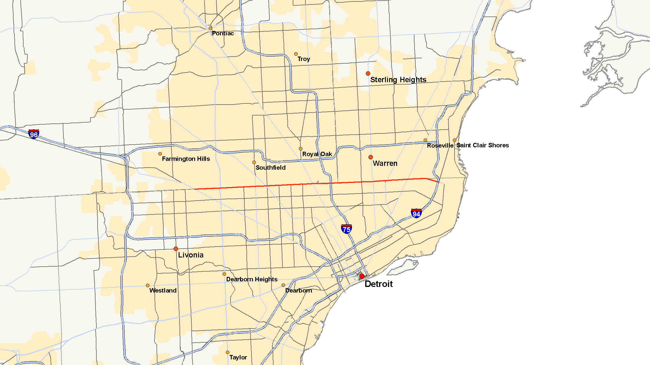
→M-102 is a state trunkline in the US state of Michigan, running along the northern boundary of Detroit. It is known as 8 Mile Road for most of its length. As part of the land surveying of the state, the road follows the Michigan Baseline, and it is called Base Line Road in places. M-102 is the physical and psychological boundary between Detroit and the northern suburbs. M-102 is routed on only a portion of 8 Mile Road which extends both east and west of the M-102 designation. The routing of M-102 changes to Vernier Road just west of Beaconsfield Road. M-102's eastern terminus is at the junction of Vernier and I-94. Its western terminus is at the junction of 8 Mile Road and M-5/Grand River Avenue. The 8 Mile Road designation continues west to Pontiac Trail near South Lyon. A discontinuous portion of 8 Mile is located west of US 23 as well.
Contents
8 Mile Road
The boundary between the city of Detroit (and Wayne County) and Detroit's northern suburbs in Oakland and Macomb counties is formed by 8 Mile Road. Residents of Detroit, and, as a whole, the state of Michigan, refer to this road (and other "mile" roads) as "Eight Mile." It extends west of Detroit and is also the boundary between Wayne and Washtenaw counties on the south and Macomb, Oakland, and Livingston counties on the north. Past Middlebelt Road in Livonia, 8 Mile Road becomes known as Base Line Road because it was the base line for surveying the Northwest Territories.
The name comes from the Mile Road System, a method used to delineate east/west roads through the Detroit area. Mile roads begin at the intersection of Woodward and Michigan Avenues in downtown Detroit; therefore 8 Mile Road is approximately 8 miles (13 km) north of that point. 8 Mile Road ends at Marshall Road in Green Oak township.
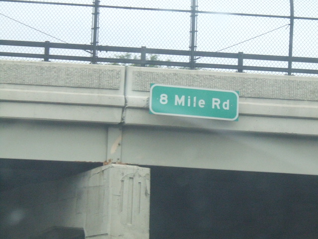
 8 Mile road overpass
8 Mile Road generally follows a straight line east of Northville. Between Griswold Street and Taft Road, 8 Mile bends toward the north, avoiding the city center before returning to its base line. Further west, 8 Mile crosses Pontiac Trail (which connects South Lyon and Ann Arbor) before becoming a dirt road; it then ends about a mile east of Whitmore Lake. West of Whitmore Lake, 8 Mile Road picks up briefly and crosses US 23. The far western end of 8 Mile past US 23, at a junction with Hall Road, a local road near Hamburg.
History
M-102
The eastern terminus of M-102 changed a number of times before the completion of I-94. Initially ending at US 25/Gratiot Avenue (present-day M-3, M-102 was, for a time, extended east, then north, to connect with M-29. However, once I-94 was completed, M-102's eastern terminus became fixed at the new freeway.[1]
Prior to the completion of the Jeffries Freeway (present day I-96), M-102 had the same western terminus as today, but for several years, M-102 extended onto a segment of what is now M-5 between the present western terminus for M-102 and the major freeway junction for M-5, I-96, I-696 and I-275. The freeway portion had previously carried I-96, as the Jeffries had originally been proposed to run along Grand River Avenue (which was signed as BS I-96). As I-96 was rerouted, Grand River southeast of its junction with 8 Mile became M-5, and M-102 was thus extended along Grand River and the former I-96. In 1994, a northerly extension originally planned as part of I-275 opened, and M-102 was scaled back to the junction of 8 Mile and Grand River, while M-5 was lengthened to include the new extension.[1]
8 Mile Road
While not very significant prior to the 1950s, 8 Mile Road is one of Michigan's more familiar roads. Starting out as dirt road, 8 Mile was designated as M-102 in 1928. It was around this time when 8 Mile was widened into a divided highway between Gratiot and Woodward, where M-102 originally ran. As more people started moving out to that area, 8 Mile Road was widened into a divided highway west of Woodward, all the way to Grand River in 1942, where M-102 was extended. In the early 1960s, 8 Mile Road was widened from a total of four lanes (two lanes on each side of the divided highway) to a total of eight lanes (four lanes on each side of the divided highway), much like it is, today. This was due to the growing population of Detroit suburbs such as Ferndale, Oak Park, Warren, Hazel Park, and Southfield.
Cultural impact
Racial and economic divide
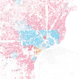 Racial distribution of Metro Detroit from 2000 Census
Caucasian African American Asian Hispanic Other (Each dot represents 25 people)The road has long served as a de facto cultural dividing line between the predominantly poor black city and its wealthier, predominantly white northern suburbs. (The suburbs of Grosse Pointe are exceptions to this cultural dividing line since they are white affluent suburbs south of 8 Mile Road. Harper Woods is another exception, being traditionally white but not affluent.) Although in fact this line has become blurred as certain communities immediately north of the road (notably Southfield, Eastpointe, and Oak Park) have gained black residents in recent years, the perception of 8 Mile as the chief dividing line between racial groups and classes persists, in part because the suburban counties of Oakland and Macomb remain, on the whole, significantly whiter and more prosperous than the city of Detroit.
According to the 2000 U.S. Census,[3] the median family income for the city of Detroit, whose population was 81.55% African-American, was $33,853, and 26.1% of the population lived below the poverty line. By contrast, the median family income for Oakland County, whose population was 82.75% white, was $75,540, and only 5.5% of residents lived below the poverty line.
The 2010 U.S. Census showed a dramatic shift in demographic numbers as affluent and middle class African American, Asian, and Hispanic populations surge in Oakland, Macomb and Washtenaw Counties, negating the tradition of 8 Mile being the racial divide of the Metro Detroit area. As of 2010 the population of Macomb County was 83.91% Non-Hispanic white, 8.65% Black, 0.31% Native American, 2.98% Asian, 0.02% Pacific Islander, 0.10% Non-Hispanics of some other race, 2.10% Two or more races and 2.27% Hispanic or Latino.While Oakland County reports In 2010, the U.S. Census Bureau estimated that non-Hispanic whites formed 76.8% of the population; African-Americans, 12.5%; Asian-Americans, 5.7%; and Hispanic or Latino people (of any race), 3.2%. Cities affected the most in Oakland County included Farmington Hills (17.4% African American, 10.1% Asian), Southfield (70% African-American),Troy (4.0% African American,19.1% Asian) and Oak Park (57% African American). Cities affected the strongest in Macomb county included Warren (13.5% African American, 4.6% Asian), Eastpointe (29.5% black or African American, 1.1% Asian, 0.2% Non-Hispanics reporting some 2.1% Hispanic or Latino and Roseville (11.7% African American ).
In media
Tupac Shakur, Tim Roth, and Thandie Newton form the fictitious musical act Eight Mile Road in the 1997 film Gridlock'd, which is set in Detroit.[4] The movie 8 Mile, starring Detroit area hip hop artist Eminem, as well as his songs "Lose Yourself" and "8 Mile", both take their names and cultural subject matter from the roadway.
There are a number of songs that refer to 8 Mile Road:
- Eminem – "Encore/Curtains Down"
- Eminem – "Marshall Mathers"
- Eminem featuring 50 Cent – "8 More Miles"
- Eminem – "Yellow Brick Road"
- Eminem – "Mockingbird"
- Uncle Kracker featuring Kid Rock and Paradime – "Heaven"
- 50 Cent – "Places to Go"
- Obie Trice - "8 Mile"
- The Game featuring Eminem – "We Ain't"
- The Game featuring Lil Wayne – "My Life"
- Freeway featuring Jay-Z – "8 Miles and Runnin' "
- Proof – "Many Men (Remix)"
In surveying
Also known as Base Line Road, 8 Mile Road marks the baseline used in the survey of Michigan land. It forms the boundary for many southern Michigan counties. Prior to the system used in Michigan, county boundaries were often set by geographic markers such as rivers, hills, and trees, and were therefore rather irregular. Michigan counties in the Lower Peninsula tend to be regularly bounded, and evenly sized, except in the cases of counties bordering one of the Great Lakes.
Where 8 Mile deviates from the base line in Northville, a portion of Base Line Road is a residential street, running from Old Novi Road to Center Street (Sheldon Road). Running slightly off alignment east of Old Novi because of a tributary of the River Rouge, Base Line reconnects to 8 Mile via Griswold Street.
Major intersections
Mileposts are only given along the M-102 designation.
County Location Mile[2] Destinations Notes Livingston–Washtenaw Hamburg Township –
Webster TownshipHall Road Green Oak Township –
Northfield Township US 23
US 23Exit 53 on US 23 Gap in 8 Mile Road Oakland–Washtenaw Lyon Township –
Salem TownshipPontiac Trail Oakland–Wayne Farmington Hills –
Livonia
 I-96 / I-275
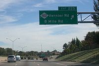
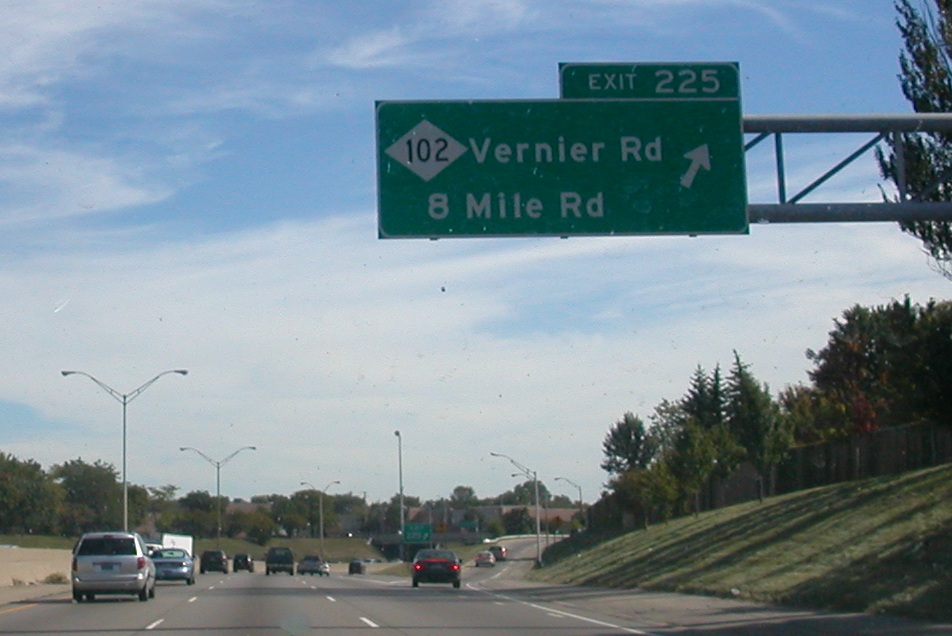
Exit 167 on I-96/I-275 0.000 M-5Western terminus of M-102 Southfield–Detroit 2.187 US 24 (Telegraph Road)Southern side of highway is in Detroit from here east 5.198 M-39 (Southfield Freeway)6.015 M-10 (Lodge Freeway)Exit 13 on M-10 Ferndale–Detroit 10.059 M-1 (Woodward Avenue)Hazel Park – Detroit 11,577 I-75 (Chrysler Freeway)Exit 59 on I-75 Macomb–Wayne Warren–Detroit 15.159 M-53 (Van Dyke Road)16.290 M-97 (Groesbeck Highway)Eastpointe–Detroit 18.096 M-3 (Gratiot Avenue)Eastpointe – Harper Woods 19.731 8 Mile Road east M-102 follows Vernier Road; 8 Mile continues east to Mack Avenue Wayne Harper Woods 20.804 I-94Eastern terminus of M-102 1.000 mi = 1.609 km; 1.000 km = 0.621 mi See also
References
- ^ a b c Bessert, Christopher J. (August 26, 2006). "Michigan Highways: Highways 100 through 119". Michigan Highways. http://www.michiganhighways.org/listings/MichHwys100-119.html#M-102. Retrieved October 29, 2006.
- ^ a b "Control Section/Physical Reference Atlas". Michigan Department of Transportation. 2001. http://mdotwas1.mdot.state.mi.us/public/maps/pr/. Retrieved March 28, 2008.
- ^ "American FactFinder". United States Census Bureau. http://factfinder.census.gov. Retrieved 2008-01-31.
- ^ Coker, Cheo Hodari (January 25, 1997). "Various Artists 'Gridlock'd: The Soundtrack', Death Row/Interscope". Los Angeles Times. http://articles.latimes.com/1997-01-25/entertainment/ca-21850_1_tupac-shakur. Retrieved September 19, 2011.
External links
Categories:- State highways in Michigan
- Interstate 96
- Culture of Detroit, Michigan


Wikimedia Foundation. 2010.