- Southfield, Michigan
Infobox Settlement
official_name = Southfield, Michigan
settlement_type =City
nickname =
motto = "The center of it all"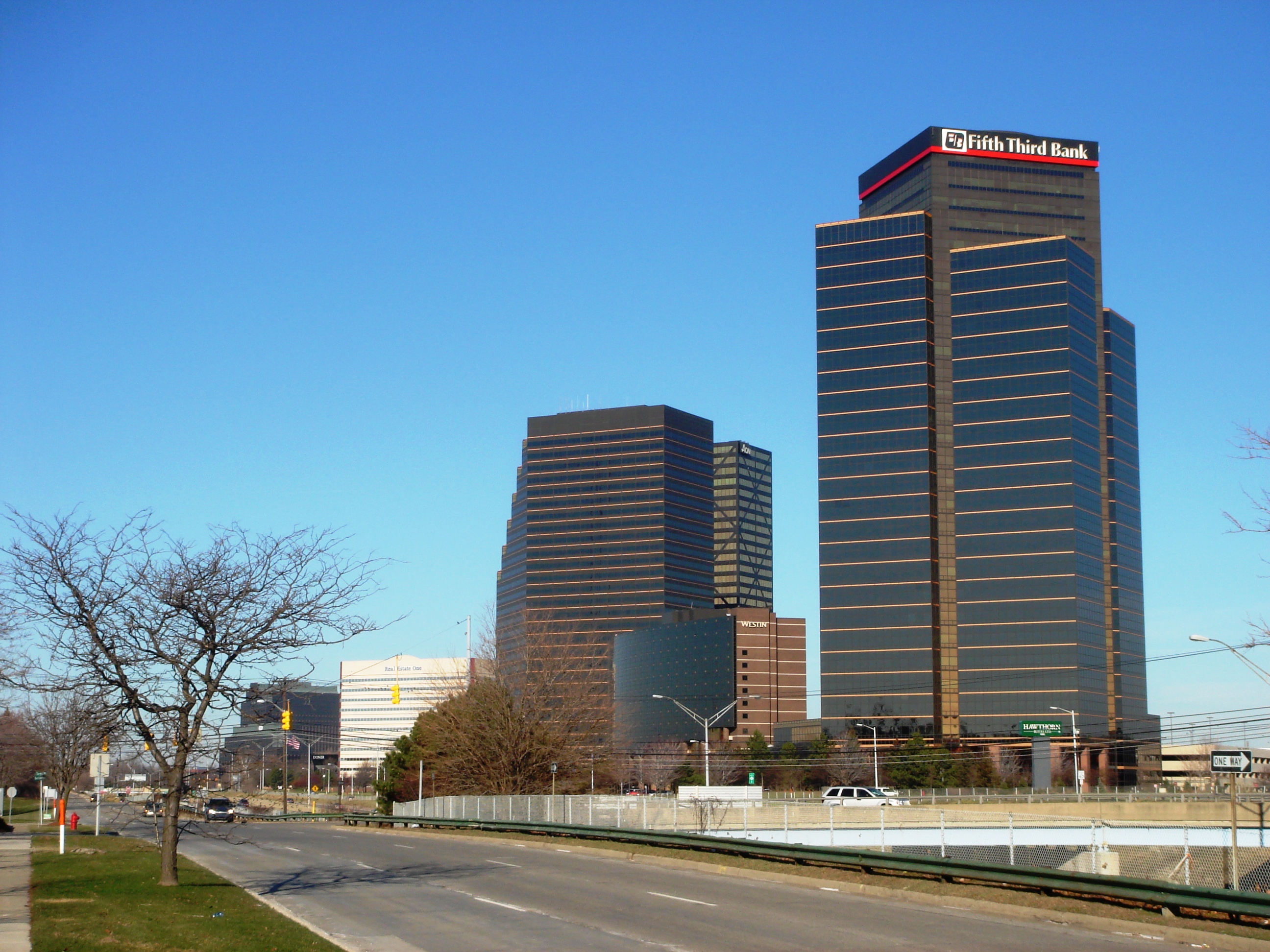
imagesize =
image_caption = "Southfield Town Center "
image_
image_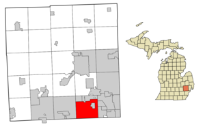
mapsize = 250x200px
map_caption = Location in the state ofMichigan
mapsize1 =
map_caption1 =
subdivision_type = Country
subdivision_type1 = State
subdivision_type2 = County
subdivision_name =United States
subdivision_name1 =Michigan
subdivision_name2 = Oakland
established_title = Founded
established_date = 1823
established_title2 = Incorporation
established_date2 = 1958
government_type =Council-Manager
leader_title =Mayor
leader_name =Brenda L. Lawrence
leader_title1 = City Administrator
leader_name1 = James G. Scharret
area_magnitude =
area_total_km2 = 68.0
area_land_km2 = 67.9
area_water_km2 = 0.1
population_as_of = 2000
population_total = 78296
population_metro = 5456428
population_density_km2 = 1152.5
timezone = EST
utc_offset = -5
timezone_DST = EDT
utc_offset_DST = -4
latd = 42 |latm = 28 |lats = 47 |latNS = N
longd = 83 |longm = 14 |longs = 42 |longEW = W
area_total_sq_mi = 26.2
area_land_sq_mi = 26.2
area_water_sq_mi = 0.0
elevation_m = 208
elevation_ft = 682
postal_code_type =ZIP code s
postal_code = 48000-48099
area_code = 248
blank_name = FIPS code
blank_info = 26-74900GR|2
blank1_name = GNIS feature ID
blank1_info = 0638439GR|3
footnotes =
website =Southfield is a city in Oakland County of the
U.S. state ofMichigan . It is asuburb of Detroit and is part of theMetro Detroit area. As of the 2000 census, the city had a total population of 78,296. Southfield Township is adjacent to the city on the north side. A part ofMetro Detroit 's upscale office market, the city's marque is a cluster of five golden skyscrapers that form the contemporary convert|2200000|sqft|m2|-2|sp=usSouthfield Town Center office complex with a Westin Hotel and a conference center. In addition, a 33-story luxuryresidential high-rise is separate from the complex. Southfield has other skyscrapers. To the west, near the confluence of I-696 and M-10, is theAmerican Center .History
Southfield was surveyed in 1817 according to the plan by Michigan territorial governor
Lewis Cass . The first settlers came from Birmingham and Royal Oak,Michigan , as well as the states ofNew York andVermont . The city was founded by John Daniels in 1823. Among the [http://www.pioneercem.com founders] where the Heth's, Stephens, Harmon, McClelland and Thompson families. It was first organized as a township onJuly 12 ,1830 . Southfield took its name from its location in the "south fields" of Bloomfield Township. A post office was established in 1833 and the first town hall built in 1873. The Southfield Fire Department was formed onApril 6 ,1942 and the Southfield Police Department in 1953.A portion of the township incorporated as a city on
April 28 ,1958 . The current city hall was built in 1964 as part of the new Civic Center complex, which also became home to Southfield's police headquarters. The Civic Center was expanded in 1971 to include a sports arena with swimming pool. Evergreen Hills Golf Course was added in 1972, and in 1978, a new public safety building, theSouthfield Pavilion and a new court building was added. In 2003, an expanded and redesignedSouthfield Public Library opened to the public on the Civic Center grounds, featuring state-of-the-art facilities. Outside the Civic Center complex, Southfield also has municipal parks and recreation facilities, which were largely developed in the 1970s, including Beech Woods Recreation Center and John Grace Community Center.The city's population growth occurred primarily between 1950 and 1990 as residents fleeing Detroit's inner city moved out to the suburbs. By the 1970s, Southfield became home to a sizeable
Jewish population which builtsynagogues and schools. By the early 1990s, many middle-classAfrican Americans had moved into the city.Economy
Southfield is a commercial center for the metropolitan Detroit area, with Southfield's convert|26000000|sqft|m2|-2|sp=us of office space surpassing that of even the city of Detroit's central business district. Several internationally-recognized corporations have major offices in Southfield, including the North American Headquarters of Denso,
Federal-Mogul ,Lear Corporation , andElectronic Data Systems . Today, more than eightyFortune 500 companies have offices in Southfield.Southfield is home to 700 acres (2.8 km²) of parkland, a nationally recognized public school district, eight colleges including
Lawrence Technological University , and Oakland Community College.Southfield's skyline is a mix of several skyscrapers built in the 1970s and 1980s and many mid- and low-rise residential and office buildings. Northland Center, built in 1954, claims to be the oldest suburban shopping mall in the United States. In 2003, Southfield unveiled its new library to the metropolitan Detroit area. The building is over convert|127000|sqft|m2|-2, houses 250 computers and 1,000 wire internet connections.
Southfield has the Consulate of Macedonia in Detroit. [ [http://consularcorpsofdetroit.com/macedonia.html Consular Corps of Detroit ] ]
Geography
According to the
United States Census Bureau , the city has a total area of 26.2 square miles (68.0 km²), of which, 26.2 square miles (67.9 km²) of it is land and 0.04% is water. The main branch of the River Rouge runs through Southfield. The city is bounded to the south byEight Mile Road , its western border is Inkster Road, and to the east it is bounded by Greenfield Road. Southfield's northern border does not follow a single road, but lies approximately around Thirteen Mile Road. The city is bordered byDetroit and Redford Township to the south,Farmington Hills to the west, Franklin, Bingham Farms, Beverly Hills to the north and Royal Oak, Berkley and Oak Park to the east. Also the completely separate city ofLathrup Village sits in the eastern part of the city and is completely surrounded by Southfield.Demographics
As of the
census GR|2 of 2000, there were 78,296 people, 33,987 households, and 19,780 families residing in the city. Thepopulation density was 2,984.6 per square mile (1,152.5/km²). There were 35,698 housing units at an average density of 1,360.8/sq mi (525.5/km²). The racial makeup of the city was 38.83% White, 54.22% African American, 0.20% Native American, 3.09% Asian, 0.03% Pacific Islander, 0.64% from other races, and 2.99% from two or more races. 1.19% of the population were Hispanic or Latino of any race.Of the city's 33,987 households, 25.3% had children under the age of 18 living with them, 40.2% were married couples living together, 14.3% had a female householder with no husband present, and 41.8% were non-families. 36.2% of all households were made up of individuals and 11.9% had someone living alone who was 65 years of age or older. The average household size was 2.27 and the average family size was 3.01.
The age distribution in the city's population was spread out with 21.6% under the age of 18, 7.9% from 18 to 24, 30.6% from 25 to 44, 24.8% from 45 to 64, and 15.2% who were 65 years of age or older. The median age was 38 years. In terms of gender distribution, for every 100 females there were 84.9 males. For every 100 females age 18 and over, there were 80.9 males.
The median income for a household in the city was $51,802, and the median income for a family was $64,543. Males had a median income of $48,341 versus $37,949 for females. The
per capita income for the city was $28,096. About 5.8% of families and 7.4% of the population were below thepoverty line , including 8.2% of those under age 18 and 10.2% of those age 65 or over.Government
Southfield utilizes the
Council-Manager form of government, and thus is governed by aCity Council consisting of seven council members. The city council appoints aCity Administrator , who manages the day-to-day operations of the city. The popularly electedMayor , who does not vote on council actions, does have the right to veto council actions and holds the power to appoint the city's planner, assessor, attorney, and members of various commissions. The city's Clerk andTreasurer are also popularly elected officials. All of these officials hold non-partisan positions.* City officials
**MayorBrenda L. Lawrence
**City AdministratorJames Scharret
**City ClerkNancy Banks
**City TreasurerIrv Lowenberg
**City Council
***Joan Seymour (President)
***Donald Fracassi (President Pro-Tem)
***Myron Frasier
***Sylvia Jordan
***Sydney Lantz
***William Lattimore
***Kenson Siver *State officials
**GovernorJennifer Granholm (D)
**State SenatorGilda Z. Jacobs (D) - 14th State Senate District
**State RepresentativePaul Condino (D) - 35th State House District*Federal officials
**SenatorCarl Levin (D)
**SenatorDebbie Stabenow (D)
**RepresentativeSander Levin (D) - 12th Congressional DistrictMedia
Southfield is also the broadcast media center for the Detroit area, boasting studios and broadcast facilities for several television stations including
WXYZ-TV ,WJBK-TV ,WKBD-TV , andWWJ-TV , and City Cable 15. The city has one radio stationWSHJ 88.3 which is sponsored by Southfield Public Schools.In addition to the News and Free Press, Detroit's two metropolitan daily newspapers that are widely distributed across Michigan, and parts of Ohio and Ontario, Southfield is served by the
Southfield Eccentric , a suburban paper that reports on local and community events, which is published twice a week, on Sunday and Thursday.Metro Detroit's sports station, FSN Detroit, is also located in Southfield on 11 mile and Evergreen Rd.
Transportation
Suburban Mobility Authority for Regional Transportation (SMART) operates local and regional bus transit.
The major thoroughfares in the city include the John C. Lodge Freeway (M-10), which is among the first urban to suburban highways constructed in the United States. The city also contains Interstate 696 (
I-696 ), Southfield freeway (M-39), and US-24/Telegraph Rd. Today, The city contains several freeway interchanges connecting local roads to the freeways. Most prominently, "The Lodge" connects downtown Detroit to "The Mixing Bowl," the sprawling interchange of I-696, US-24/Telegraph Rd, the Lodge, Northwestern Highway, Lahser Road, and Franklin Road, all of which are located in Southfield.Most major streets adhere to a north-south/east-west orientation, forming a grid of major streets spaced one mile (1.6 km) apart from each other. The major east-west streets are8 Mile Road (which forms the southern boundary of the city),9 Mile Road (which is split by the Southfield Freeway),10 Mile Road ,11 Mile Road (which is split by the Lodge), and12 Mile Road . Major north-south streets are Telegraph Road,Lahser Road ,Evergreen Road ,Southfield Road (the northern extension of theSouthfield Freeway ) and Greenfield Road (which forms the eastern boundary of the city).ee also
*
Architecture of metropolitan Detroit
*
*Lawrence Technological University
*Metro Detroit
*Tourism in metropolitan Detroit Notes
External links
* [http://www.cityofsouthfield.com/ City of Southfield]
* [http://www.sfldlib.org/ Southfield Public Library]
* [http://www.southfield.k12.mi.us/ Southfield Public Schools]
* [http://www.southfieldfirefighters.com/]
* [http://www.theoaklandcounty.com The Oakland County]
* [http://www.pioneercem.com/ Pioneer Cemetery]
Wikimedia Foundation. 2010.