- Interstate 75 in Michigan
-
This article is about the section of highway in Michigan. For the entire length of freeway, see Interstate 75.
Interstate 75
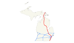
I-75 highlighted in redRoute information Maintained by MDOT Length: 395.54 mi[1] (636.56 km) Existed: 1958 – present Tourist
routes:Lake Erie Circle Tour, Lake Huron Circle Tour, Lake Michigan Circle Tour, Lake Superior Circle Tour Major junctions South end:  I-75 near Erie
 I-96 in Detroit
 I-94 in Detroit
 US 23 in Flint
 I-69 in Flint
 US 10 in Bay City
 US 127 near Grayling
North end: Canadian border on Int'l Bridge in Sault Ste. Marie Location Counties: Monroe, Wayne, Oakland, Genesee, Saginaw, Bay, Arenac, Ogemaw, Roscommon, Crawford, Otsego, Cheboygan, Emmet, Mackinac, Chippewa Highway system Main route of the Interstate Highway System
Main • Auxiliary • BusinessMichigan State Trunkline Highway System
Interstate • US • State←  M-74
M-74M-75  →
→Interstate 75 (I-75) is a part of the Interstate Highway System and runs from Miami, Florida to Sault Ste. Marie in the Upper Peninsula of Michigan. I-75 enters the state from Ohio in the south, just to the north of Toledo. It runs generally north through Detroit, Pontiac and Bay City, crossing the Mackinac Bridge and ending at the Canadian border in Sault Ste. Marie. On the Canadian side, drivers must use a series of city streets in Sault Ste. Marie, Ontario to reach Highway 17, the local route of the Trans-Canada Highway. The total length in Michigan is 395 miles (636 km).
Contents
Route description
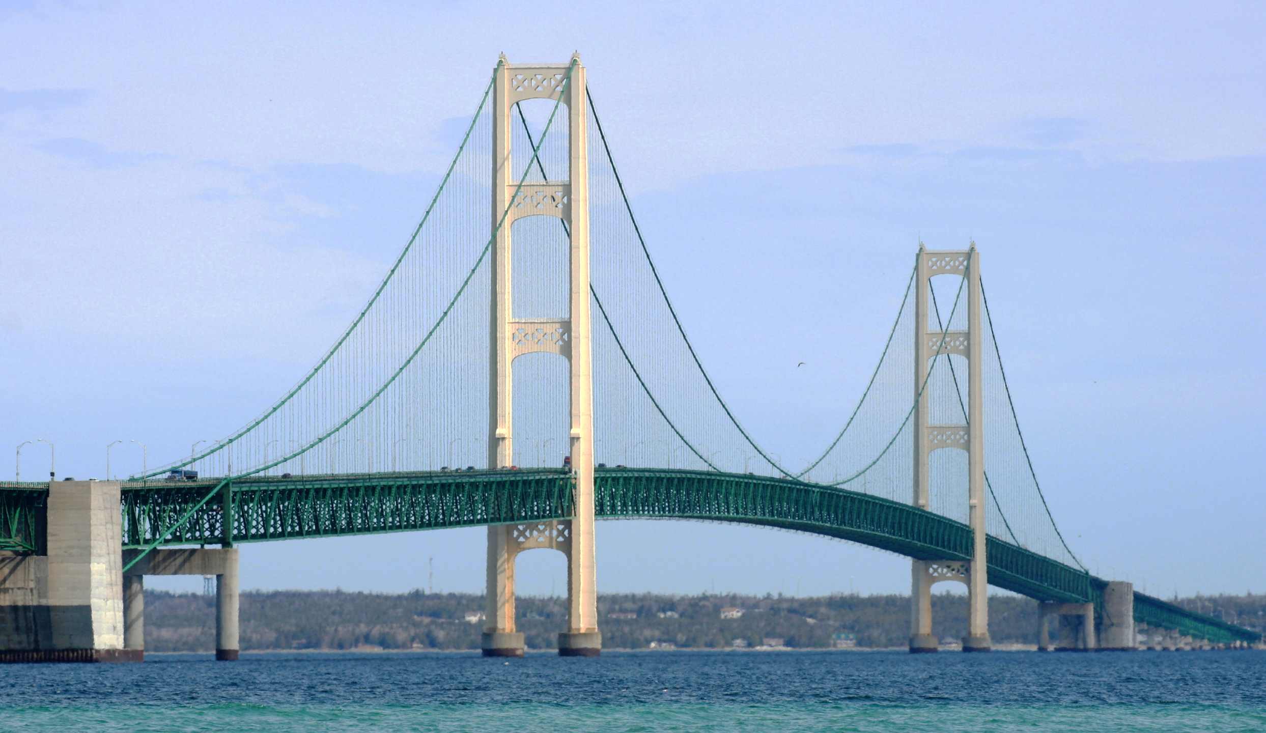
 Mackinac Bridge
I-75 connects Michigan's Upper and Lower Peninsulas via the 5-mile (8.0 km) long suspension Mackinac Bridge.
At the northern end of I-75, at Sault Ste. Marie, Michigan, the Sault Ste. Marie International Bridge leads into Canada, into Sault Ste. Marie, Ontario. This is the closest connection of any Interstate to the Trans-Canada Highway.
In Detroit, the spur route I-375 is the shortest signed spur of I-75 at 1.06 miles (1.71 km). Interstate 375 is the shortest signed Interstate Highway. In addition, at that same junction, the I-75 curve where it shifts from the Fisher Freeway to the Chrysler Freeway is one of the sharpest on a mainline route in the entire Interstate system, with a 25 mph (40 km/h) advisory speed.
Names
- The section in Cheboygan County from the southern end of the Mackinac Bridge to the south is known as the G. Mennen Williams Freeway.
- The section from the northern end of the Mackinac Bridge in Mackinac County proceeding north is known as the Prentiss M. Brown Freeway.
- The section between downtown Detroit and Pontiac is known as the (Walter P.) Chrysler Freeway. It is one of busiest segments of I-75 and hosts one of the perennially busiest segments of freeways in Michigan. The Chrysler Freeway continues south as I-375.
- The section through Southern and central Detroit to the Chrysler Freeway is known as the Fisher Freeway
- The section south of the Fisher Freeway is called the Detroit–Toledo Freeway south to the Ohio state line.
History
Pre designation
Prior to any segment of freeway in Michigan being designated as part of Interstate 75 various sections of it had been constructed.
Between the mid and late 1950s the following sections were constructed:
- US 2 between what is now known as BL I-75 in St. Ignace and M-123 was the Upper Peninsula's first segment.
- Alt US 24 between Ohio border and US 25 (now M-125) was the first segment of Michigan's I-75 to cross the state border; and the only freeway to cross the border until the early 1960s.
- Mackinac Bridge (on what was then US 27) was completed in 1957.
- M-20 (now part of US 10) - when this segment became US 10; it carried the temporary Interstate 75 designation.
-
This transport-related list is incomplete; you can help by expanding it.
Post designation
In 1960 the Zilwaukee Bridge, a Bascule bridge across the Saginaw River was constructed.[2]
In the 1960s, I-75 had several discontiguous segments connected with roads with "TO I-75" signs in addition to US 10 doubling as "TEMP I-75".
The section between Grayling, Michigan and M-32 was built in 1961. Between Higgins Lake and Grayling, it was built by converting the northbound lanes of U.S. Route 27 to southbound lanes and building a new set of northbound lanes leaving the former southbound lanes as a strip of grass. The terminus of the freeway near downtown Grayling was converted to a partial interchange for what would become BL I-75. Alongside that, the former segment of US 27 between Grayling and Gaylord, Michigan was turned back to local control. After this individual segment of freeway was completed, it left a gap between Gaylord and Indian River which was filled in a year later. While the gap was being filled in, a special "TO I-75" designation was applied to the former segment of US 27. Around that time, US 27's northern terminus was scaled back to 5 miles (8.0 km) south of Grayling until it was redesignated as an extension of US 127 in 2001.
A 12-mile (19 km) section of I-75 was opened between Gaylord and Waters in July 1962.[3]
In Detroit the Fisher Freeway was built in 'the early 1960s'[4] and then the Chrysler Freeway in 1967.[5]
Until the early 1970s, I-75 between Bay City and Grayling was routed west to Clare (along US-10 then north along then-US-27, and was signed as "TEMP I-75". This freeway segment had some at-grade intersections at the time. In 2002 the portion between Clare and Grayling was redesignated as an extension of US 127, although it was posted as US 127 on a National Geographic road atlas in the year 2000.
The section between Alger and Roscommon was completed in 1973, and the temporary section reverted to U.S. routes, although of freeway quality.
Until the completion of I-75 in 1973, the stretch of freeway between Standish and West Branch had the designation of M-76. When the I-75 signs were erected along the freeway, M-76 vanished from the state road map after 53 years of existence.
In the 1988 the original bascule Zilwaukee Bridge across the Saginaw River was replaced by a much higher structure slightly north of the former bridge.[2]
Until 1987, US 10 and I-75 were the same road between Bay City and Clarkston. Both also overlapped US 23 between Bay City and Flint. Now, Bay City serves as the eastern terminus of US 10.
As late as 1990, US 31 and US 23 both had their northern termini on I-75's southern approach to the Mackinac Bridge. Even though US 27 was scaled back 94 miles (from Mackinaw City to south of Grayling) in 1961, a lone sign assembly showed all three US highways ending at the same place as late as 1971.
Late 2000s
Beginning on February 25, 2008, the Interstate closed completely to traffic in both directions from Rosa Parks Boulevard (Exit 49) to Clark Street (Exit 47) in Detroit.[6] This facilitated the complete rebuilding of the road as part of the Gateway Project to better connect Interstates 75 and 96 to the Ambassador Bridge. Through traffic on 75 was instructed to take I-94 to I-275 and local detours were posted. The freeway re-opened to through traffic in July 2009, hence about all of the signs on I-75 within Detroit's city limits are in the Clearview typeface.
Spur routes
- I-275 - Begins as a loop from Northern Monroe County and continues to connect up with Interstate 696. Was going to connect back up with I-75 north of Pontiac. Serves the Western population of Wayne County and Detroit Metro Airport.
- I-375 - Is the shortest signed Interstate in the nation. It serves the immediate downtown Detroit area.
- I-475 - Known as the U.A.W. Freeway. Serves Flint's downtown areas as I-75 goes to the west side of the city.
- I-675 - A loop into the city of Saginaw and back out north of the city. Served as an alternate to I-75 when the drawbridge over the Saginaw River was still operating.
Exit list
County Location Mile Exit Destinations Notes Monroe Erie Township 0.00 I-75 – ToledoOhio state line 1.66 2 Summit Street Southbound exit and northbound entrance 2.49 2 
 CONN M-125 – Erie
Northbound exit and southbound entrance 4.60 5 Erie Road – Erie, Temperance Diamond interchange Luna Pier 5.78 6 Luna Pier Diamond interchange La Salle Township 8.62 9 South Otter Creek Road – La Salle Folded diamond interchange Monroe Charter Township 11.36 11 La Plaisance Road – Downtown Monroe Diamond interchange Monroe 13.45 13 Front Street – Monroe Folded diamond interchange 13.57 14 Elm Avenue Folded diamond interchange Frenchtown Charter Township 15.21 15 Dixie Highway – Downtown Monroe Former M-50; diamond interchange 18.03 18 Nadeau Road Diamond interchange 20.26 20  I-275 north – Flint
To Detroit Metro Airport Berlin Charter Township 21.45 21 Swan Creek Road – Newport To Newport Road; folded diamond interchange South Rockwood 26.32 26 South Huron River Drive – South Rockwood Wayne Rockwood 26.93 27 North Huron River Drive – Rockwood Folded diamond interchange Brownstown Charter Township 27.96 28 
 M-85 north (Fort Street) / LECT
Northbound exit and southbound entrance; southern terminus of M-85 and northern end of LECT concurrency; half trumpet interchange Flat Rock 28.80 29 Gibraltar, Flat Rock Signed as exits 29A (Gibraltar) and 29B (Flat Rock) southbound. Six-ramp parclo AB4 interchange Woodhaven 31.79 32 West Road Signed as exits 32A (east) and 32B (west); six-ramp parclo B4 interchange Brownstown Charter Township 33.67 34A  To US 24 (Telegraph Road)
Southbound exit and northbound entrance; partial diamond interchange 34.00 34B Sibley Road, Dix Highway Signed as exit 34 northbound; diamond interchange Taylor 35.06 35 US 24 (Telegraph Road)Northbound exit and southbound entrance; partial Y interchange. 35.92 36 Eureka Road Four-ramp parclo A3 interchange Taylor–
Southgate37.06 37 Allen Road, Northline Road Diamond interchange Lincoln Park 39.84 40 Dix Highway Two-level turbine interchange 40.67 41  M-39 (Southfield Road)
Six-ramp parclo A4 interchange Melvindale 41.81 42 Outer Drive Diamond interchange Detroit 43.13 43 M-85 (Fort Street) / LECT / Schaefer HighwaySigned as exits 43A (south) and 43B (north) southbound; former northern terminus of M-85; Southern end of LECT concurrency; six-ramp parclo AB4 interchange 44.83 44 Dearborn Street Northbound exit and southbound entrance; partial diamond interchange 45.57 45 M-85 (Fort Street) / Springwells StreetDiamond interchange 46.46 46 Livernois Avenue Diamond interchange 47.42 47A Clark Street Former M-3, Signed as exit 47 northbound; diamond interchange 48.02 47B Ambassador Bridge to Canada
LECTTo Highway 3; southbound exit and northbound entrance; northern end of LECT concurrency 48.27 47C Vernor Highway Southbound exit and northbound entrance 48.85 48 I-96 west (Jeffries Freeway) – LansingEastern terminus of I-96 49.87 49  M-10 (Lodge Freeway) / Rosa Parks Boulevard – Civic Center
Signed as exits 49A (Rosa Parks Boulevard) and 49B (M-10) southbound; three-level turbine interchange 50.16 50 Grand River Avenue Access to Comerica Park 50.82 51B 
 M-3 (Gratiot Avenue via Fisher Freeway) to M-53
Signed as exit 51 northbound 50.97 51C  I-375 south (Chrysler Freeway) – Downtown Detroit
Sharp turn 25 miles per hour (40 km/h); three-level turbine interchange 51.76 52 Mack Avenue Diamond interchange 52.50 53A Warren Avenue Diamond interchange 53.06 53B I-94 (Ford Freeway) – Port Huron, ChicagoThree-level cloverstack interchange 53.48 54 East Grand Boulevard, Clay Avenue Diamond interchange Hamtramck 55.14 55 Holbrook Avenue, Caniff Avenue Diamond interchange Detroit 56.17 56  M-8 (Davison Freeway)
Signed as exits 56A (east) and 56B (west); three-level turbine interchange 56.95 57 McNichols Road Diamond interchange 58.02 58 7 Mile Road Diamond interchange Wayne–Oakland Detroit–
Hazel Park59.01 59  M-102 (8 Mile Road)
Three-level diamond interchange Oakland Hazel Park 60.11 60 John R. Street, 9 Mile Road Diamond interchange Hazel Park–
Ferndale–
Madison Heights–
Royal Oak61.40 61  I-696 (Reuther Freeway) – Port Huron, Lansing
Four-level stack interchange Royal Oak–
Madison Heights62.38 62 11 Mile Road, 10 Mile Road west Diamond interchange Madison Heights 63.38 63 12 Mile Road Six-ramp parclo A4 interchange Madison Heights–
Troy65.41 65 14 Mile Road Signed as exits 65A (east) and 65B (west). Six-ramp parclo B4 interchange Troy 67.62 67 Rochester Road Four-ramp parclo A2 interchange 69.17 69 Big Beaver Road Signed as exits 69A (east) and 69B (west); cloverleaf interchange with collector-distributor lanes 72.28 72 Crooks Road Indirect accsess to Crooks Road, requires exiting onto a trumpet interchange with Corporate Drive to reach Crooks Road Bloomfield Township 74.31 74 Adams Road Folded diamond interchange 75.64 75  BL I-75 north (Square Lake Road) – Pontiac
Signed as Square Lake Road southbound; full Y interchange Auburn Hills 77.58 77  M-59 – Utica, Pontiac
Signed as exits 77A (east) and 77B (west). Cloverleaf interchange 78.59 78 Chrysler Drive 79.25 79 University Drive – Rochester Six-ramp parclo A4 interchange 81.22 81  M-24 / BL I-75 south – Lapeer, Oxford
Access to The Palace of Auburn Hills; double trumpet interchange 83.11 83 Joslyn Road Signed as exits 83A (north) and 83B (south) southbound; east entrance to Great Lakes Crossing; six-ramp parclo AB4 interchange 84.34 84 Baldwin Road Signed as exits 84A (north) and 84B (south) northbound; west entrance to Great Lakes Crossing; six-ramp parclo AB4 interchange Independence Township 88.75 89 Sashabaw Road 90.99 91  M-15 – Clarkston, Davison
Six-ramp parclo A4 interchange Springfield Township 92.79 93 US 24 (Dixie Highway) – WaterfordNorthern terminus of US 24 98.21 98 East Holly Road Folded diamond interchange Groveland Township 101.19 101 Grange Hall Road – Fenton, Ortonville Four-ramp parclo A2 interchange Holly Township 106.33 106 Dixie Highway Southbound exit and northbound entrance 106.63 106 Saginaw Road – Grand Blanc Northbound exit and southbound entrance Genesee Grand Blanc 108.86 108 Holly Road – Grand Blanc Diamond interchange 110.08 109  M-54 (Dort Highway) – Burton
Southern terminus of M-54; combination of a trumpet and cloverleaf interchange 111.88 111  I-475 north – Downtown Flint
Northbound exit and southbound entrance; partial Y interchange Mundy Township 115.12 115 US 23 south – Ann ArborSouthern end of US 23 concurrency; southbound exit and northbound entrance; partial Y interchange Flint 116.49 116  Bristol Road – Bishop International Airport
Signed as exits 116A (east) and 116B (west) southbound; former M-121; seven-ramp parclo AB4 interchange Flint Township 117.38 117 I-69 / Miller Road – Port Huron, LansingSigned as exits 117A (I-69) and 117B (Miller Road); I-69 interchange is a three-level cloverstack, Miller Road interchange is a four-ramp parclo A3 interchange 118.91 118  M-21 (Corunna Road) – Owosso
Folded diamond interchange Mount Morris Township 122.11 122 Pierson Road – Flushing Six-ramp parclo A4 interchange 125.59 125 I-475 south – Downtown FlintSemi-directional T interchange 126.13 126 Mt. Morris Diamond interchange Vienna Township 131.21 131  M-57 – Clio, Montrose
Saginaw Birch Run 136.29 136  M-54 / M-83 – Birch Run, Frankenmuth
Northern terminus of M-54; southern terminus of M-83 Bridgeport Township 144.69 144 Frankenmuth, Bridgeport Signed as exits 144A (Frankenmuth) and 144B (Bridgeport) northbound Buena Vista Township 149.40 149  M-46 (Holland Avenue) – Sandusky
Signed as exits 149A (east) and 149B (west) 149.72 150  I-675 north – Downtown Saginaw
151.88 151  M-81 – Caro, Reese
153.08 153  M-13 (East Bay City Road) – Saginaw
Saginaw River Zilwaukee Bridge Zilwaukee 154.02 154 Zilwaukee Zilwaukee Township 155.96 155 I-675 south – Downtown SaginawBay Frankenlust Township 160.30 160  M-84 (Saginaw Road)
Monitor Township 162.81 162  US 10 west / M-25 east / BL I-75 east – Downtown Bay City, Clare
Eastern terminus of US 10; western terminus of M-25 and BL I-75; signed as 162A (east) and 162B (west) 164.31 164
CONN M-13 – KawkawlinKawkawlin Township 168.05 168 Beaver Road Fraser Township 173.01 173 Linwood Road – Linwood Pinconning Township 181.02 181 Pinconning Road – Pinconning Arenac Lincoln Township 188.65 188 US 23 north – Alpena, StandishNorthern end of US 23 concurrency: Southbound exit and northbound entrance 190.97 190  M-61 – Gladwin, Standish
Adams Township 195.08 195 Sterling Road – Sterling Moffatt Township 202.87 202  M-33 north – Mio, Cheboygan
Ogemaw Horton Township 212.13 212 BL I-75 north (Cook Road) – West BranchOgemaw Township 215.73 215 
 M-55 east / BL I-75 south to M-30 – Tawas City, West Branch
Western end of M-55 concurrency Roscommon Richfield Township 222.83 222 Old 76 – St. Helen Former M-76 Backus Township 227.60 227 M-55 west – Cadillac, Houghton LakeEastern end of M-55 concurrency Higgins Township 239.61 239  M-18 / BL I-75 north – Roscommon, Houghton Lake
Gerrish Township 244.26 244 BL I-75 south – Roscommon, North Higgins Lake State ParkCrawford Beaver Creek Township 250.02 249 US 127 – Lansing, ClareSouthbound exit and northbound entrance; northern terminus of US 127 Grayling Township 251.03 251 4 Mile Road Grayling 254.11 254  BL I-75 north to M-72 – Downtown Grayling, Traverse City
Northbound exit and southbound entrance 256.14 256 North Down River Road Southbound exit and northbound entrance Grayling Township 259.19 259  M-93 (Hartwick Pines Road) / BL I-75 south to M-72 – Downtown Grayling, Traverse City
Signed as M-93 only (northbound) Maple Forest Township 264.23 264 Frederic, Lewiston Otsego Otsego Lake Township 270.83 270 Waters Bagley Township 279.05 279 BL I-75 north (Old 27) – Downtown GaylordFormer US 27; signed as Old 27 only (southbound) Gaylord 281.95 282  M-32 / BL I-75 south – Downtown Gaylord, Alpena
Signed as M-32 only (northbound) Vanderbilt 290.70 290 Old 27 – Vanderbilt Cheboygan Nunda Township 300.97 301  C-58 – Wolverine
Indian River 310.16 310  M-68 – Indian River, Rogers City
313.49 313  M-27 north – Cheboygan, Indian River
Southern terminus of M-27 Munro Township 322.51 322  C-64 – Cheboygan, Pellston
Hebron Township 326.71 326  C-66 – Cheboygan, Cross Village
Mackinaw Township 335.69 336 
 US 31 south / LMCT south – Petoskey, Charlevoix
Southbound exit and northbound entrance; northern terminus of US 31 and southern end of LMCT concurrency Cheboygan–Emmet Mackinaw Township–
Wawatam Township337.72 337 Nicolet Street north – Mackinaw City Northbound exit and southbound entrance; southern terminus of the former M-108 Emmet Mackinaw City 338.47 338  US 23 south / LHCT south – Cheboygan, Rogers City, Alpena
Southbound exit and northbound entrance; northern terminus of US 23; southern end of LHCT, signed as the GLCT from here north 338 Michigan Welcome Center Northbound exit only 339.22 339 Jamet Street Straits of Mackinac Mackinac Bridge Mackinac St. Ignace 343.80 343 Bridge View Park Southbound exit only 344.38 344 
 US 2 west / BL I-75 north / GLCT – St. Ignace, Escanaba, Manistique
Signed as exits 344A (north) and 344B (west) northbound, BL I-75 not signed southbound
Eastern terminus of the western US segment of US 2; southern terminus of BL I-75
LMCT follows exit 344A to US 2 and LHCT follows exit 344B to BL I-75345.08 345 Portage Street – St. Ignace Southbound exit and northbound entrance St. Ignace Township 348.10 348 BL I-75 south / LMCT – St. Ignace
 H-63 north / Mackinac Trail
Signed as BL I-75 southbound and H-63 northbound; southern end of LMCT concurrency 352.15 352  M-123 north – Newberry
Southern terminus of M-123 359.37 359  M-134 east / LMCT – Drummond Island, De Tour Village
Western terminus of M-134; northern end of LMCT concurrency Chippewa Rudyard Township 373.71 373  M-48 east (H-40) – Pickford, Rudyard
Western terminus of M-48 Kinross Township 377.88 378  M-80 east – Kinross
Western terminus of M-80 379.64 379 Gaines Highway – Barbeau Area Dafter Township 386.27 386 
 M-28 / LSCT west – Munising, Newberry
Southern end of LSCT concurrency Sault Ste. Marie 392.57 392  BS I-75 north (3 Mile Road) / LMCT – Sault Ste. Marie
Southern end of LMCT concurrency signed as GLCT concurrency 394.74 394 Easterday Avenue – Sault Ste. Marie, Soo Locks St. Marys River International Bridge to Canada 1.000 mi = 1.609 km; 1.000 km = 0.621 mi
Concurrency terminus • Closed/Former • Incomplete access • UnopenedAuxiliary routes of Interstate 75 
References
- ^ Route Log - Main Routes of the Eisenhower National System Of Interstate and Defense Highways - Table 1
- ^ a b Bessert, Chris (31 Jan 2009). "In Depth: The Zilwaukee Bridge". MichiganHighways.org. http://www.michiganhighways.org/indepth/zilwaukee.html.
- ^ "State Briefs". Argus-Press (Owosso, Michigan): p. 4. July 7, 1962.
- ^ Detroit's Corktown. http://books.google.co.uk/books?id=1JVigb8HjIAC&pg=PA39&lpg=PA39&dq=fisher+freeway+history&source=bl&ots=8_h01XnABx&sig=OYswsr7qduEbHZG9xvyzVPN53Rk&hl=en&ei=ZwpnTNaODtW14Abf96GZBA&sa=X&oi=book_result&ct=result&resnum=5&ved=0CCoQ6AEwBA#v=onepage&q=fisher%20freeway%20history&f=false.
- ^ "Detroit and Eastern Market History". http://www.angelfire.com/mi3/templatesdotcom/Detroit_and_EM_history.htm.
- ^ MDOT - Ambassador Bridge Gateway Project
External links
Interstate 75Previous state:
OhioMichigan Next state:
TerminusFreeways in metropolitan Detroit Fisher (I-75) • Edsel Ford (I-94) • Jeffries (I-96) • I-275 • Chrysler (I-375) • Walter Reuther (I-696)
Northern Michigan Topics Major Highways Central cities Satellite cities Region Outlying regions Counties See also: MichiganCategories:
- Interstate 75
- Interstate Highways in Michigan
- Lake Superior Circle Tour
- Lake Michigan Circle Tour
- Lake Huron Circle Tour
- Lake Erie Circle Tour
- Transportation in Monroe County, Michigan
- Transportation in Wayne County, Michigan
- Transportation in Oakland County, Michigan
- Transportation in Genesee County, Michigan
- Transportation in Saginaw County, Michigan
- Transportation in Bay County, Michigan
- Transportation in Arenac County, Michigan
- Transportation in Ogemaw County, Michigan
- Transportation in Roscommon County, Michigan
- Transportation in Crawford County, Michigan
- Transportation in Otsego County, Michigan
- Transportation in Cheboygan County, Michigan
- Transportation in Emmet County, Michigan
- Transportation in Mackinac County, Michigan
- Transportation in Chippewa County, Michigan


Wikimedia Foundation. 2010.