- M-25 (Michigan highway)
-
This article describes a Michigan state trunkline highway numbered M-25. For the former U.S. Highway, see U.S. Route 25 in Michigan; for other uses, see M25 (disambiguation)
M-25
M-25 highlighted in redRoute information Maintained by MDOT Length: 146.99 mi[3] (236.56 km) Existed: 1933[1][2] – present Tourist
routes:Lake Huron Circle Tour Major junctions South end: 
 BL I-69 / BL I-94 at Port Huron
 M-90 at Lexington
 M-46 at Port Sanilac
 M-142 at Harbor Beach
 M-53 at Port Austin
M-142 at Bay Port
 M-24 at Unionville
 M-15 near Bay City
West end: 


 I-75 / US 23 / US 10 / BS I-75 at Bay City
Location Counties: St. Clair, Sanilac, Huron, Tuscola, Bay Highway system Michigan State Trunkline Highway System
Interstate • US • State← M-24M-26  →
→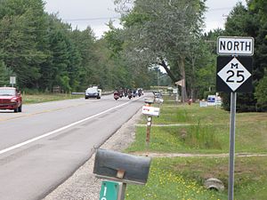 An M-25 reassurance marker
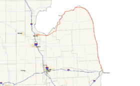
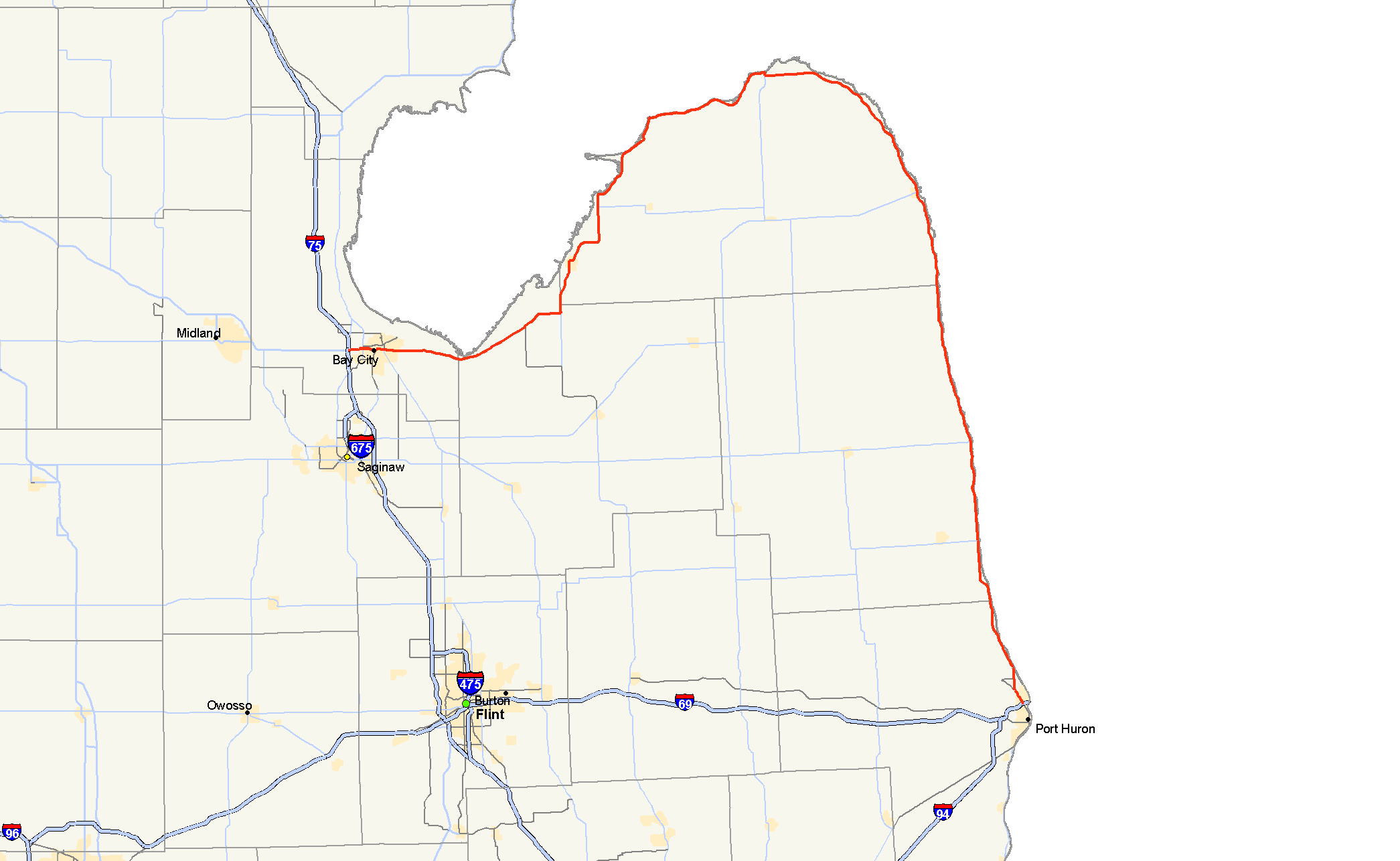
M-25 is a state trunkline highway in the US state of Michigan. The route follows an arc-like shape closely along the Lake Huron shore of the Thumb in the eastern Lower Peninsula between Port Huron and Bay City. It serves the lakeshore resorts along Lake Huron and Saginaw Bay and generally lies within sight of the lake and the bay. All is surface road and generally scenic, except for the freeway segment near the junction with I-75 and connection into the US 10 freeway.
Between Port Huron and Port Austin it is the north–south highway that used to be US 25 before the designation was removed from Michigan. Between Port Austin and Bay City it is an east–west route that appeared on some maps as US 25 and on some maps as a M-25. Since the 1970s, when all of US 25 was deleted north of Cincinnati, Ohio it is now entirely M-25.
Contents
Route description
North to Port Austin
The starting point of M-25 at a junction with Business Loop I-69/Business Loop I-94 (BL I-69/BL I-94) in Port Huron. M-25 is part of the Lake Huron Circle Tour for its entire length.[4] From here M-25 heads north on Pine Grove Avenue until meeting M-136. At this intersection, M-25 turns north on 24th Avenue to Lakeshore Road then runs parallel to the Lake Huron shoreline.[5]
In the community of Lakeport, M-25 passes through Lakeport State Park. Past the park, M-25 changes names from Lakeshore Road to Kimball Road temporarily. M-25 intersects the east end of M-90 blocks from Lake Huron in Lexington. There are public beaches in Lexington and in Port Sanilac. M-25's street name changes after the M-46 intersection to that of North Lakeshore Road. The Huron Shores Golf Club is located off the highway north of Port Sanilac at the intersection of Snover Road. Sanilac County has established the Sanilac County Park at the intersection of Downington Road and M-25 south of Richmondville. North of Forestville M-25 is once again called South Lakeshore Road as the highway crosses into Huron County.[4][5]
Wagener County Park is located off M-25 in the community of Helena. M-25 beings to curve to the northwest in Sand Beach near the Rock Falls Cemetery. In the city of Harbor Beach, M-25 is called Huron Avenue and meets M-142 for the first of two occasions. Here is the Harbor Beach Golf Course on the south side of town as M-25 moves inland through town. North of town, the trunkline parallels an old routing of the Chesapeake & Ohio Railway as it is once again renamed Lakeshore Road. The highway moves farther inland north of Rubicon and Port Hope as it begins to round the tip of the Thumb. In Grindstone City, M-25 loses the Lakeshore Road name in favor of Grindstone Road all the way to Port Austin.[4][5]
West to Bay City
Port Austin is the location of the historical northern terminus of US 25. Through town, M-25 turns north along Lake Street before continuing west on Port Austin Road along the lake. West of town, M-25 turns south along the Saginaw Bay and meets Port Crescent State Park. From here south west, M-25 hugs the bay and its miles of beaches. North of Caseville is the Albert E. Sleeper State Park. Through Caseville, M-25 uses Main Street and passes the city beach off State Street. McKinley is home to the Scenic Golf & Country Club and Wild Fowl Bay. M-25 follows the shore of Wild Fowl Bay, a smaller bay off Saginaw Bay, to the city of Bay Port and the western terminus of M-142 on Fairhaven a smaller community south of Bay Port. From here south, the road is called Unionville Road and turns inland to Sebewaing.[4][5]
At Unionville, M-25 turns more westerly to round the bottom of Saginaw Bay into Bay City along Bay City-Forestville Road in Tuscola County. In the community of Quanicassee, it transitions to Center Road and crosses into Bay County. M-25 is routed the one-way street pair of 7th Street and McKinley Street before crossing the Veterans Memorial Bridge over the Saginaw River. West of the bridge, the one-way pairing of Jenny Street and Thomas Street are used before the two merge into Thomas Street west of the M-13 intersections.[4][5]
The western terminus is at the junction of I-75/US 23 and US 10. As the roadway crosses the I-75/US 23 freeway it feeds into the eastern end of US 10 freeway.[4]
History
Previous designation
The M-25 designation was first used by July 1, 1919. in the Upper Peninsula. The highway ran from Skandia along what is today M-94 to Munising. From there it used today's routing of M-28 eastward to Newberry and Sault Ste. Marie.[6] This designation was replaced by M-28 in 1927.[7]
Current designation
In 1933, US 25 was extended north from Port Huron to Port Austin. along M-29. M-25 was designated along the portion of M-29 disconnected by the US 25 extension, from Bay City to Port Austin.[1][2] M-25 was extended along US 25 to Port Huron when the latter was removed from Michigan in 1973.[8][9] The southern terminus was placed at I-94 in Marysville, Michigan until it was moved northward to end at BL I-94 (now BL I-69/BL I-94) in 1987.[10][11]
The section of M-25 in the City of Bay City was named a history heritage route by the Michigan Department of Transportation (MDOT). This designation was made on 10 23, 1997 for the section of M-25 along Center Avenue between Madison Avenue and the eastern city limits.[12]
Major intersections
County Location Mile[3] Destinations Notes St. Clair Port Huron 0.00 BL I-69 / BL I-94 (Hancock Street)
 To I-69 west / I-94 west / Bridge to Canada (LHCT)
Southern end of LHCT concurrency 1.75  M-136 west (Pine Grove Avenue)
Eastern terminus of M-136 Sanilac Lexington 11.59 M-90 west (Huron Avenue)Eastern terminus of M-90 Port Sanilac 22.96 M-46 west (Main Street)Eastern terminus of M-46 Huron Harbor Beach 52.44 M-142 west (State Street)Eastern terminus of M-142 Port Austin 77.10 M-53 south (Lake Street)Northern terminus of M-53; historic northern terminus of US 25 Fairhaven 106.11 M-142 east (Pigeon Road)Western terminus of M-142 Tuscola Unionville M-24 south (Center Street)Northern terminus of M-24 Bay Bay City 142.92 M-15 south (Trumbull Street)Northern terminus of M-15  M-84 south (Washington Avenue) / BS I-75 ends
Northern terminus of M-84; eastern terminus of BS I-75 145.55 
 M-13 / LHCT (Euclid Avenue)
Northern end of LHCT concurrency 146.99 I-75 / US 23 – Saginaw, Mackinac Bridge
US 10 west / BS I-75 ends – ClareWestern terminus of M-25/BS I-75 and eastern terminus of US 10; road continues westward as US 10; exit 162 on I-75/US 23 1.000 mi = 1.609 km; 1.000 km = 0.621 mi
Concurrency terminus • Closed/Former • Incomplete access • UnopenedReferences
- ^ a b Michigan State Highway Department (October 1, 1932). Official Highway Service Map (Map). Cartography by Rand McNally.
- ^ a b Michigan State Highway Department (September 1, 1933). Official Highway Service Map (Map). Cartography by Rand McNally.
- ^ a b Michigan Department of Transportation (2001). Control Section/Physical Reference Atlas (Map). http://mdotwas1.mdot.state.mi.us/public/maps/pr/. Retrieved January 25, 2008.
- ^ a b c d e f Michigan Department of Transportation (2010). Official Department of Transportation Map (Map). 1 in:15 mi/1 cm:9 km. Section I12–K14.
- ^ a b c d e Google, Inc. Google Maps – Michigan (Map). Cartography by Google, Inc. http://maps.google.com/. Retrieved May 10, 2008.
- ^ Michigan State Highway Department (July 1, 1919). State of Michigan: Upper Peninsula (Map). Cartography by MSHD.
- ^ Michigan State Highway Department (December 1, 1927). Official Highway Service Map (Map). Cartography by MSHD.
- ^ Michigan Department of State Highways (1973). Official Highway Map (Map). 1 in:14.5 mi. Section I13–K14.
- ^ Michigan Department of State Highways and Transportation (1974). Official Highway Map (Map). 1 in:14.5 mi. Section I13–K14.
- ^ Michigan Department of Transportation (1987). Official Transportation Map (Map). Port Huron inset.
- ^ Michigan Department of Transportation (1988). Department of Transportation Map (Map). Port Huron inset.
- ^ "Bay City Receives Historic Heritage Route Designation" (Press release). Michigan Department of Transportation. October 23, 1997. Archived from the original on December 12, 2008. http://replay.waybackmachine.org/20081212001534/http://www.michigan.gov/mdot/0,1607,7-151-9620_11057-94343--,00.html. Retrieved May 10, 2008.
External links
Categories:- State highways in Michigan
- Lake Huron Circle Tour
- U.S. Route 25
- Dixie Highway
- Bay City, Michigan
- Transportation in Bay County, Michigan


Wikimedia Foundation. 2010.