- M-60 (Michigan highway)
-
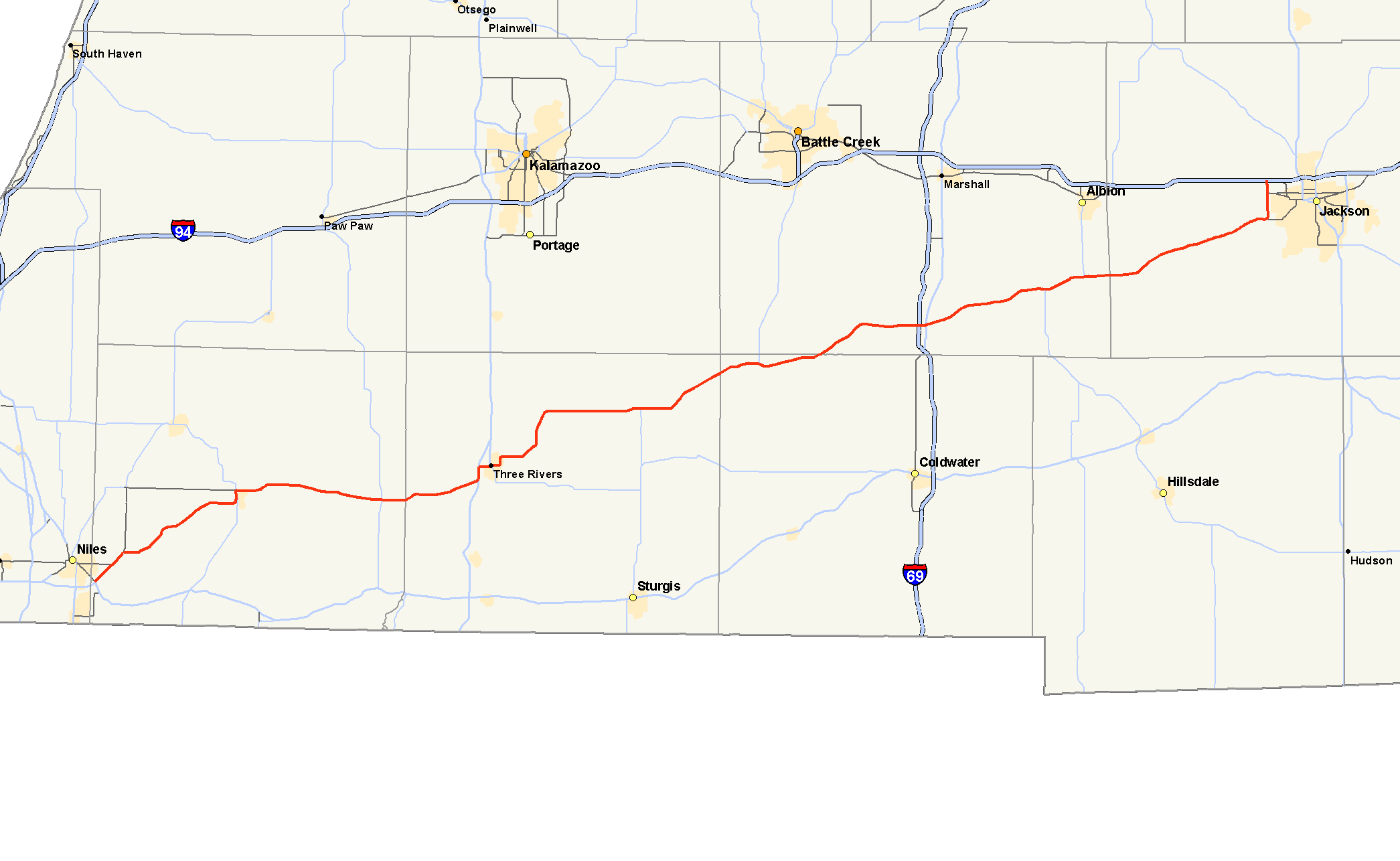
M-60

M-60 highlighted in redRoute information Maintained by MDOT Length: 104.224 mi[2] (167.732 km) Existed: c. July 1, 1919[1] – present Major junctions West end:  US 12 near Niles
 M-62 in Cassopolis
 M-40 in Jones

 US 131 / M-86 in Three Rivers
 M-66 from Mendon to near Athens
 I-69 near Tekonsha
 M-99 near Homer
East end:  I-94 near Jackson
Location Counties: Cass, St. Joseph, Branch, Calhoun, Jackson Highway system Michigan State Trunkline Highway System
Interstate • US • State←  M-59
M-59M-61  →
→M-60 is an east–west state trunkline highway in the US state of Michigan. It runs from the Niles area at a junction with US Highway 12 (US 12) to the Jackson area where it ends at Interstate 94 (I-94). The trunkline passes through a mix of farm fields and woodlands, crosses or runs along several rivers and connects several small towns of the southern area of the state. The westernmost segment runs along divided highway while the easternmost section is a full freeway bypass of Jackson.
M-60 was originally designed in 1919 with the rest of the state highway system in Michigan. It ran roughly along its current route connecting downtown Niles to downtown Jackson. In the mid 1920s, the western end was extended to New Buffalo; since then several bypasses of the smaller towns along the highway were added. One of these bypasses resulted in the creation of an alternate route (Alternate M-60, ALT M-60) through Concord; that route has since been decommissioned. When Niles was bypassed in the 1950s, a business loop (Business M-60, BUS M-60) was created through town. After the western end was truncated to its current location, that business loop was converted to a business spur.
Contents
Route description
M-60 starts at an interchange along US 12 southeast of Niles in southwestern Cass County. From this interchange, the highway runs northeasterly along the divided highway on Detroit Road to an intersection with BUS M-60 (Yankee Road). There, the main highway turns due east along the shore of Barron Lake. The trunkline continues through mixed farm fields and woodlands, running northeastward to Cassopolis and rounding Stone Lake on the southern approach to town. M-60 runs north–south through town on Broadway Street, merging with M-62 to run concurrently into downtown Cassopolis. M-60 turns eastward on State Street, separating from M-62, and leaves town[3][4] while crossing a line of the Canadian National Railway.[5]
East of Cassopolis, M-60 runs past Diamond Lake and through farm fields. At Vandalia, the highway passes Donnell Lake before meeting M-40 north of Bair Lake in Jones. East of Jones, the trunkline crosses into St. Joseph County and meets US 131 on the south side of Three Rivers. The two highways run concurrently northward through a retail business corridor to an intersection with Michigan Avenue. M-60 turns east along Michigan Avenue following BUS US 131 into downtown. The business loop turns north at the same intersection where M-60 meets M-86 near the Rocky River crossing. Continuing eastward, M-60 passes the high school and Three Rivers Municipal Dr. Haines Airport while running along the St. Joseph River. The trunkline turns north, runs by Fishers Lake and continues out of town through farm fields. Near Mendon, the highway runs along the river again. East of town, M-60 meets M-66, and the two run east and northeast through Leonidas into the extreme northwest corner of Branch County.[3][4]
South of Athens, M-66 turns northward and M-60 continues around Union City and into southern Calhoun County. The road runs through Burlington on Leroy Street. At Marshall Street. M-60 meets the southern end of M-311 which runs north to the Battle Creek area. M-60 continues east through farm fields to Tekonsha where it meets Interstate 69 (I-69) northwest of town. Continuing to Homer, the highway runs along Lehigh Street in town; M-99 merges into M-60 after the intersection with Hillsdale Street. East of town, the highway widens into a four-lane divided highway; M-99 turns north along this short section of roadway and M-60 reverts to a two-lane highway again. The trunkline crosses the Kalamazoo River at Concord before it crosses into Jackson County. At Spring Arbor, M-60 passes the campus of Spring Arbor University. Outside of Jackson, the highway widens out to a full freeway bypass around the west side of the city. This bypass has one interchange with Michigan Avenue near Jackson County Airport. North of this interchange, the highway picks up the Business Loop I-94[3][4] and crosses the Norfolk Southern Railway line in the area.[5] The freeway ends at a trumpet interchange with I-94 northwest of Jackson.[3][4]
M-60 is maintained by the Michigan Department of Transportation (MDOT) like other state highways. Among these responsibilities, the department tracks the level of traffic that uses the roadways under its jurisdiction. This is expressed using a metric called annual average daily traffic (AADT), which is a statistical calculation of the average daily number of vehicles on a segment of roadway. According to MDOT's surveys in 2009, the highest traffic counts were 12,547 cars and 999 trucks along the freeway immediately south of I-94 near Jackson; the lowest AADT was the 2601 cars and 384 trucks west of Union City.[6] Only two sections of M-60 have been listed on the National Highway System (NHS): along the US 131 concurrency in Three Rivers[7] and on the BL I-94 concurrency near Jackson.[8] The NHS is a network of roads important to the country's economy, defense, and mobility.[9]
History
M-60 was designated with the rest of the original state highway system by July 1, 1919, on a series of roads running between Niles and Jackson by way of Cassopolis, Three Rivers and Tekonsha.[1][a] By the end of 1927, the western end was extended to terminate at US 12 at New Buffalo.[11] In the early to mid 1930s, the Michigan State Highway Department (MSHD) realigned the New Buffalo – Niles section to bypass Galien and Buchanan. The former M-60 that ran into Buchanan was renumbered M-174 at the time, and the department extended US 112 concurrently along M-60 to New Buffalo.[12][13] M-60 was rerouted around Concord in 1933,[14][15] Tekonsha was bypassed by the MSHD in late 1936,[13][16] and the highway was routed around Union City in 1937.[17][18] The MSHD continued to improve the highway through the end of the 1930s. The last segment between Tekonsha and Homer was paved in 1940, making all of M-60 a hard-surfaced roadway.[19][20]
In late 1949 or early 1950, the MSHD shifted M-60 through the Jones area to straighten the roadway.[21][22] The US 131 bypass of Three Rivers opened in 1953; the US 131/M-60 concurrency became a BUS US 131/M-60 concurrency through town as a result.[23][24] In late 1956 or early 1957, the highway department bypassed Niles, converting the route through town into a business loop. BUS M-60 connected the bypass into downtown where it continued along BUS US 112 back to US 112/M-60.[25][26] At the end of the 1950s, M-60 was moved to a freeway bypass along the west side of Jackson; the final mile was also designated BUS US 12 as both highways connected to the I-94/US 12 freeway north of the city.[27][28][b] The western end was redesignated as a part of US 12 in the late 1961,[29][30] and the M-60 designation was truncated off this roadway in 1966.[31][32] M-60's routing has remained unchanged since.[3]
Major intersections
County Location Mile[2] Destinations Notes Cass Milton Township 0.000 US 12 – Coldwater, New BuffaloParclo interchange Howard Township 2.164 
 BUS M-60 west – Niles
Eastern terminus of BUS M-60 Cassopolis 13.753 M-62 south – EdwardsburgSouthern end of M-62 concurrency 14.320 M-62 north – DowagiacNorthern end of M-62 concurrency Newberg Township 25.709 M-40 – Paw PawSt. Joseph Three Rivers 33.328–
33.618 US 131 south – ConstantineSouthern end of US 131 concurrency 34.304–
34.506 US 131 north – Kalamazoo


BUS US 131 northNorthern end of US 131 concurrency
Western end of BUS US 131 concurrency35.372
BUS US 131 north
M-86 east – ColdwaterEastern end of BUS US 131 concurrency
Western terminus of M-86Mendon Township –
Leonidas Township49.168 M-66 south – SturgisWestern end of M-66 concurrency Branch Sherwood Township 59.394 M-66 north – Battle CreekEastern end of M-66 concurrency Calhoun Burlington 68.353  M-311 north – Battle Creek
Southern terminus of M-311 Tekonsha Township 72.679–
72.702 I-69 – Lansing, Fort WayneExit 25 on I-69 Homer 82.956 M-99 south – HillsdaleWestern end of M-99 concurrency Homer Township –
Albion Township86.166 M-99 north – AlbionEastern end of M-99 concurrency Jackson Summit Township 101.200 Freeway begins Blackman Township 103.255  BL I-94 east
Southern end of BL I-94 concurrency; parclo interchange 104.224 I-94 – Detroit, Chicago
BL I-94 endsNorthern end of BL I-94 concurrency at exit 138 1.000 mi = 1.609 km; 1.000 km = 0.621 mi
Concurrency terminus • Closed/Former • Incomplete access • UnopenedSpecial routes
There have been two different special routes of M-60. Business M-60 (BUS M-60) in Niles is still in existence, while Alternate M-60 (ALT M-60) in Concord has been decommissioned.
BUS M-60

BUS M-60
Location: Niles Length: 2.554 mi[2] (4.110 km) Existed: c. 1957[25][26]–present Business M-60 (BUS M-60) is a state business spur running through the city of Niles and adjacent townships. The spur starts at the intersection with M-51 (Main Street, 11th Street) and runs eastward along a former routing of M-60 on Oak Street through a residential section of town. Near the Berrien–Cass county line, the highway passes south of the Jerry Tyler Memorial Airport. East of the airport, the street name changes from Oak Street to Yankee Road, and BUS M-60 runs to its terminus at M-60 (Detroit Road).[33] The total length is 2.554 miles (4.110 km),[2] and 5,284–7,984 cars and 333 trucks use the route each day.[6]
The business route was a loop route, continuing through downtown along BUS US 112[b] when the designation was created in late 1956 or early 1957.[25][26] M-60 was truncated west of Niles in 1966; at the same time, BUS M-60 was truncated at its junction with BUS US 12/M-51[c] near downtown.[31][32]
ALT M-60

ALT M-60
Location: Concord Length: 2 mi[37] (3 km) Existed: 1933[14][15]–1934[35][36] ALT M-60 was an alternate loop route running through Concord. It acted as a "business route" into downtown Concord during its short lifetime after a bypass of town along M-60 was built. Its appearance predated the development of business routes in Michigan. Concord was bypassed in 1933, resulting in the creation of the alternate route.[14][15] That route was turned over to local control the next year, decommissioning the designation.[35][36]
Footnotes
- ^ The first state highways in Michigan were signed in 1919.[10]
- ^ a b Several business loops were renumbered in 1961 as the US 12 designation was moved off the I-94 freeway to replace the US 112 designation in the state. BUS US 12 routes, like the one in Jackson, were redesignated BL I-94 routes, and BUS US 112 routes, like the one in Niles, became BUS US 12 routes.[29][30]
- ^ In April 2010, the BUS US 12 designation was decommissioned when the central portion was turned over to local control and an extended M-139 replaced it on its west end. The eastern section became just M-51.[34]
References
- ^ a b Michigan State Highway Department (July 1, 1919). State of Michigan: Lower Peninsula (Map). Cartography by MSHD.
- ^ a b c d Michigan Department of Transportation (2009). MDOT Physical Reference Finder Application (Map). Cartography by Michigan Center for Geographic Information. http://www.mcgi.state.mi.us/prfinder/. Retrieved April 15, 2011.
- ^ a b c d e Michigan Department of Transportation (2010). Official Department of Transportation Map (Map). 1 in:15 mi/1 cm:9 km. Section N8–M11.
- ^ a b c d Google, Inc. Google Maps – Overview Map of M-60 (Map). Cartography by Google, Inc. http://maps.google.com/maps?f=d&source=s_d&saddr=M-60+E%2FDetroit+Rd&daddr=42.04537,-85.30564+to:42.14669,-84.80697+to:Unknown+road&hl=en&geocode=FTbvfQIdHmDc-g%3BFbqPgQId2Fbq-ilJkz1l3rgXiDEjytwjZspykw%3BFYIbgwIdxvLx-ikPtg4QD109iDGJ6dhUIw9Itg%3BFT_4hAIdMvz2-g&mra=ls&via=1,2&sll=42.26197,-84.469714&sspn=0.029696,0.029097&ie=UTF8&t=h&z=9. Retrieved April 15, 2011.
- ^ a b Michigan Department of Transportation (April 2009) (PDF). Michigan's Railroad System (Map). http://www.michigan.gov/documents/MDOT_Official_Rail_130897_7.pdf. Retrieved September 14, 2010.
- ^ a b Bureau of Transportation Planning (2008). "Traffic Monitoring Information System". Michigan Department of Transportation. http://mdotnetpublic.state.mi.us/tmispublic/. Retrieved April 15, 2011.
- ^ Michigan Department of Transportation (April 23, 2006) (PDF). National Highway System, Michigan (Map). http://www.michigan.gov/documents/MDOT_NHS_Statewide_150626_7.pdf. Retrieved October 7, 2008.
- ^ Michigan Department of Transportation (2005) (PDF). National Highway System: Jackson Urbanized Area (Map). http://www.michigan.gov/documents/MDOT_NHS_Jackson_150615_7.pdf. Retrieved January 1, 2011.
- ^ "The National Highway System". Federal Highway Administration. August 26, 2010. http://www.fhwa.dot.gov/planning/nhs/. Retrieved January 1, 2011.
- ^ "Michigan May Do Well Following Wisconsin's Road Marking System". Grand Rapids Press: p. 10. September 20, 1919.
- ^ Michigan State Highway Department (December 1, 1927). Official Highway Service Map (Map). Cartography by MSHD.
- ^ Michigan State Highway Department (July 1, 1930). Official Highway Service Map (Map). Cartography by H.M. Gousha.
- ^ a b Michigan State Highway Department (June 1, 1936). 1936 Official Michigan Highway Map (Map). Cartography by Rand McNally. Section N7–N8, M10.
- ^ a b c Michigan State Highway Department (May 1, 1933). Official Michigan Highway Map (Map). Cartography by Rand McNally.
- ^ a b c Michigan State Highway Department (September 1, 1933). Official Michigan Highway Map (Map). Cartography by Rand McNally.
- ^ Michigan State Highway Department (December 15, 1936). 1936/7 Official Michigan Highway Map (Map). Cartography by Rand McNally (Winter ed.). Section M10.
- ^ Michigan State Highway Department (May 15, 1937). 1937 Official Michigan Highway Map (Map). Cartography by Rand McNally (Summer ed.). Section M10.
- ^ Michigan State Highway Department (December 1, 1937). 1937/8 Official Michigan Highway Map (Map). Cartography by Rand McNally (Winter ed.). Section M10.
- ^ Michigan State Highway Department (July 15, 1940). 1940 Official Michigan Highway Map (Map). Cartography by Rand McNally (Summer ed.). Section M10.
- ^ Michigan State Highway Department (December 1, 1940). 1940 Official Michigan Highway Map (Map). Cartography by Rand McNally (Winter ed.). Section M10.
- ^ Michigan State Highway Department (July 1, 1949). Michigan Official Highway Map (Map). Section N8.
- ^ Michigan State Highway Department (April 15, 1950). Michigan Official Highway Map (Map). Section N8.
- ^ Michigan State Highway Department (April 15, 1953). 1953 Official Highway Map (Map). Section N9.
- ^ Michigan State Highway Department (October 1, 1953). 1953 Official Highway Map (Map). Section N9.
- ^ a b c Michigan State Highway Department (October 1, 1956). 1956 Official Highway Map (Map). Niles inset.
- ^ a b c Michigan State Highway Department (April 1, 1957). 1957 Official Highway Map (Map). Niles inset.
- ^ Michigan State Highway Department (1958). Official Highway Map (Map). Section M11. (Includes all changes through July 1, 1958)
- ^ Michigan State Highway Department (1960). Official Highway Map (Map). Section M11. (Includes all changes through July 1, 1960)
- ^ a b Michigan State Highway Department (1961). Official Highway Map (Map). Section M11, N8. (Includes all changes through July 1, 1961)
- ^ a b Michigan State Highway Department (1962). Official Highway Map (Map).
- ^ a b Michigan Department of State Highways (1966). Official Highway Map (Map). Section N7–N8.
- ^ a b Michigan Department of State Highways (1967). Official Highway Map (Map). Section N7–N8.
- ^ Google, Inc. Google Maps – Overview Map of BUS M-60 (Map). Cartography by Google, Inc. http://maps.google.com/maps?f=d&source=s_d&saddr=Oak+St&daddr=M-60+BUS+E%2FYankee+St&hl=en&geocode=FV06fgIdff_b-g%3BFS44fgIdsMPc-g&mra=ls&sll=41.828546,-86.197765&sspn=0.01495,0.014548&ie=UTF8&t=h&z=14. Retrieved April 15, 2011.
- ^ "Forum set for bridge project". The Herald-Palladium (St. Joseph, MI). April 27, 2010. http://www.theh-p.com/articles/2010/04/27/local_news/1377890.txt. Retrieved April 27, 2010. (subscription required)
- ^ a b Michigan State Highway Department (July 1, 1934). Official Michigan Highway Map (Map). Cartography by Rand McNally.
- ^ a b Michigan State Highway Department (September 1, 1934). Official Michigan Highway Map (Map). Cartography by Rand McNally.
- ^ Google, Inc. Google Maps – Overview Map of former ALT M-60 (Map). Cartography by Google, Inc. http://maps.google.com/maps?f=d&hl=en&saddr=homer+rd+%26+spring+arbor+rd.,+concord,+mi&daddr=S+Main+St+%26+Homer+Rd,+Concord,+Jackson,+Michigan+49237,+United+States&layer=&ie=UTF8&sll=42.173009,-84.65116&sspn=0.040075,0.060081&z=15&om=1. Retrieved April 8, 2007.
External links
Categories:- State highways in Michigan
- Western Michigan
- U.S. Route 12

Wikimedia Foundation. 2010.