- M-78 (Michigan highway)
-
This article is about the state highway in Michigan; for other uses, see M78 (disambiguation)
M-78
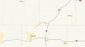
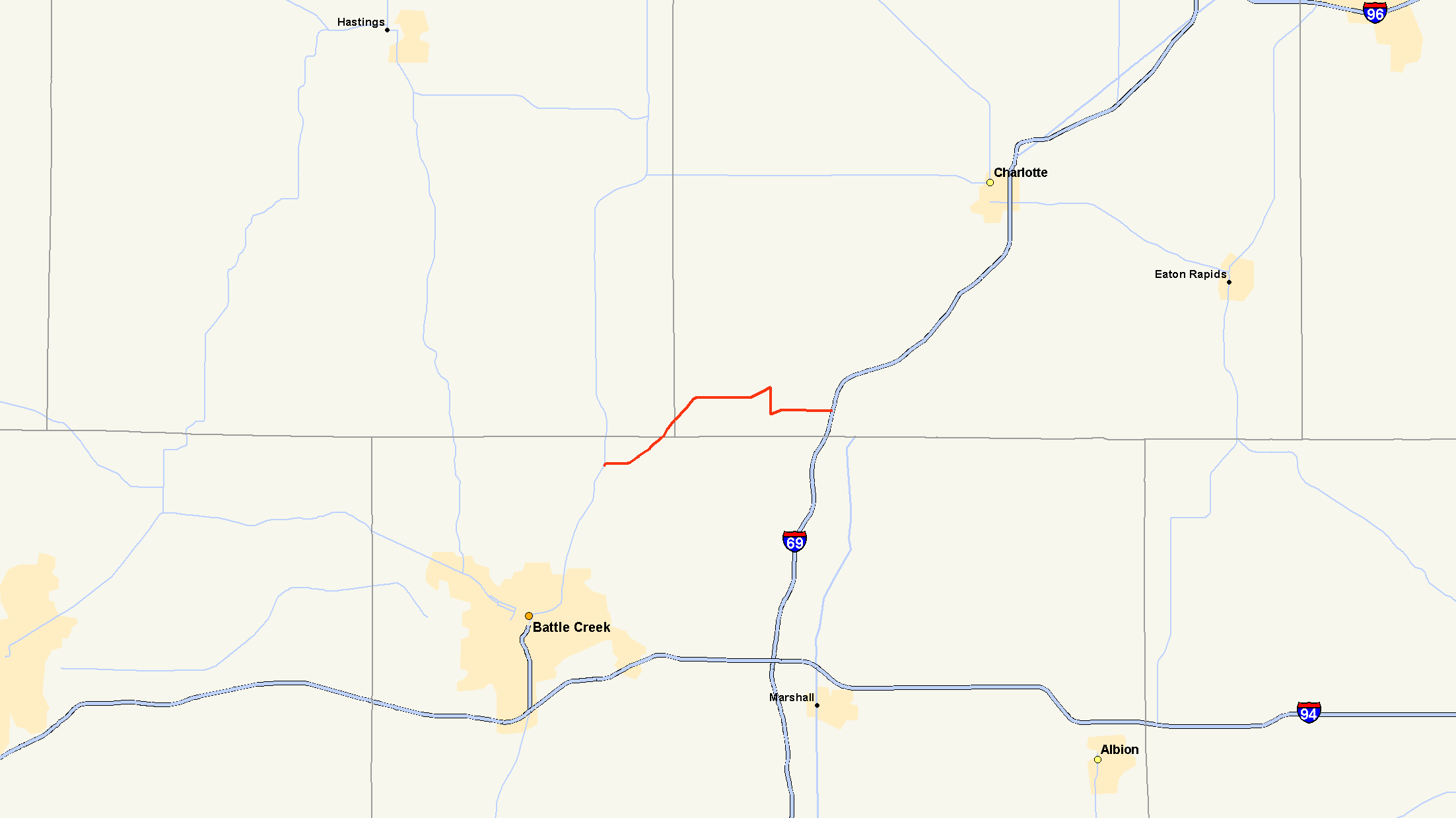
M-78 highlighted in redRoute information Maintained by MDOT Length: 10.744 mi[2] (17.291 km) Existed: c. July 1, 1919[1] – present Major junctions West end:  M-66 north of Battle Creek
East end:  I-69 Exit 48 near Olivet
Location Counties: Calhoun, Barry, Eaton Highway system Michigan State Trunkline Highway System
Interstate • US • State←  M-77
M-77M-79  →
→M-78 is a state trunkline highway in the US state of Michigan. The western terminus is the intersection with M-66 north of Battle Creek in Pennfield Township. The roadway runs 10.744 miles (17.291 km) through rural farmland and the community of Bellevue as it approaches its eastern terminus at an interchange with Interstate 69 (I-69) near Olivet. The highway is used by between 3,100 and 5,300 vehicles on a daily basis.
When the state highway system was signed in 1919, M-78 followed a similar routing. At Bellevue, it turned northeast to terminate at Charlotte. In the 1920s, the highway was extended southerly to the Indiana state line near Sturgis and northeasterly into the Lansing area. In the 1930s, M-78 was extended further on its northern and eastern end to Flint. The highway was converted into a freeway in sections starting in the 1960s. During that decade, the southern extension from the 1920s was removed from M-78 and added to other state highways, and in the 1970s, the northeastern extensions, now mostly freeways, were removed from M-78 as well. Two special routes were created as a result of the various reroutings in the Lansing area, both of which are no longer part of the state highway system.
Contents
Route description
M-78 begins at an intersection with M-66 in Pennfield Township, north of Battle Creek in Calhoun County. The trunkline passes through rural farm lands as it runs due east and northeast. It briefly crosses the southeast corner of Barry County as it enters Eaton County. There M-78 follows Battle Creek Highway past some small ponds and into the town of Bellevue. The trunkline becomes Capitol Avenue in town and turns south onto Main Street in the middle of the central business district.[3][4] M-78 crosses a branch line of the Canadian National Railway before leaving town.[4][5] Main Street turns easterly and becomes Butterfield Highway. M-78 crosses the Battle Creek River before terminating at I-69's exit 48 in Bellevue Township.[3][4]
M-78 is maintained by the Michigan Department of Transportation (MDOT) like other state highways in Michigan. As a part of these maintenance responsibilities, the department tracks the volume of traffic that uses the roadways under its jurisdiction. These volumes are expressed using a metric called annual average daily traffic, which is a statistical calculation of the average daily number of vehicles on a segment of roadway. MDOT's surveys in 2010 showed that the highest traffic levels along M-78 were the 5,256 vehicles daily on Capitol Avenue in Bellevue; the lowest counts were the 3,176 vehicles per day in Calhoun County.[6] No part of M-78 has been listed on the National Highway System,[7] a network of roads important to the country's economy, defense, and mobility.[8]
History
When the original state highway system was designated c. July 1, 1919, M-78 ran along a route similar that of today. It started north of Battle Creek at a junction with then M-79 and cut through the corner of Barry County to Bellevue, but it turned northeasterly to end at Charlotte at a junction with M-29.[1] By 1927, M-78 was extended southward, replacing M-79 to the Indiana state line, connecting with State Road 9 (SR 9) south of Sturgis. At the same time, a northerly addition extended the highway concurrently along US Highway 27 (US 27) to Dewitt and then solo to a junction with M-47 near Pittsburg.[9] The section north of Lansing was changed in 1929. The section from Dewitt Pittsburg was redesignated M-104, and M-78 was extended through East Lansing to Haslett.[10][11] By 1936, the highway was extended all the way into Flint to end at M-21.[12] Around the same time, a second routing through downtown Lansing for US 27/M-78 was designated along Capitol Avenue; the former route along Main, Kalamazoo and Larch streets and Grand Avenue was given the Truck M-78 designation.[13]
In the latter half of 1941 or the beginning of 1942, a section of the concurrent M-78/M-86 was rerouted west of Colon in St. Joseph County.[14][15] In 1950, the bridge across the Grand River on Main Street was completed; after completion, the mainline M-78 was routed over the bridge and up Larch Street, replacing Truck M-78 in the process. The former car-only route on Capitol Avenue was removed from the state highway system.[16][17] By the middle of 1960, the first section of freeway along M-78 was opened in the Lennon area.[18] The next year, the freeway had been extended as far southwest as Durand from the end at Lennon.[19] By the start of 1962, M-78 was a freeway from Perry at the junction with M-47 all the way to Swartz Creek near Flint.[20]
In 1963, the I-96 freeway was completed around the south and west sides of Lansing, and the I-496 freeway was completed north into downtown from I-96. M-78 was rerouted from the I-96/US 27 interchange southwest of Lansing east along I-96 and then north on I-496. From there, M-78 followed the one-way pairing of Homer and Howard streets from the northern end of the freeway up to the one-way couplet of Saginaw Street and Grand River Avenue, returning to its previous routing. The former route through downtown along US 27 was redesignated Business M-78 (BUS M-78) at the same time.[21][22]
M-66 was extended southerly from Assyria through Battle Creek to the Indiana state line replacing sections of M-78 in 1965.[23][24] The US 127 freeway was completed from Mason north to Lansing in 1966, adding the US 127 designation along the I-496/M-78 freeway.[25][26] The next year, M-78's freeway was extended eastward to I-75/US 10/US 23 in Flint.[27][28] The US 127/M-78 freeway was extended north of I-496 in 1969, and a discontinuous section of M-78 freeway east of Flint was completed around the same time frame.[29][30] In 1970, the I-496 freeway was completed and the BUS M-78 designation was removed through Lansing.[31][32] In 1972, the highway was rerouted to run east of Bellevue to Olivet instead of northeast to Charlotte.[33][34] The next year, all of M-78 northeast of Olivet was removed when I-69 between Charlotte and I-96 southwest of Lansing was completed; this truncation produced the modern routing of M-78 in the state.[34][35]
Major intersections
County Location Mile[2] Destinations Notes Calhoun Pennfield Township 0.000 M-66 – Battle Creek, IoniaBarry No major junctions Eaton Bellevue Township 10.744 I-69 – Fort Wayne, LansingExit 48 on I-69 1.000 mi = 1.609 km; 1.000 km = 0.621 mi Related routes
Truck route

TRUCK M-78
Location: Lansing Length: 1.5 mi[36] (2.4 km) Existed: c. 1936[13]–1950[16][17] TRUCK M-78 was a former truck route through the city of Lansing. It started at the corner of Capitol Avenue and Main Street and ran along Main Street to Grand Avenue. There, it turned north on Grand Avenue to Kalamazoo Street and turned east on Kalamazoo over the Grand River. At Larch Street, TRUCK M-78 continued north to rejoin the mainline at the corner of Larch and Saginaw streets.[16]
By the middle of 1936, the US 27/M-78 routing through Lansing was split into two. The mainline was restricted to cars only and moved to run along Capitol Avenue. The former routing was restricted to trucks only and designed as a truck route.[13] In 1950, the bridge for Main Street over the Grand River was completed and mainline US 27 was rerouted to use it to connect to Larch Street. From there north, US 27/M-78 followed Larch Street supplanting the truck route, which was decommissioned at that time.[16][17]
Business route

BUS M-78Location: Lansing Length: 9.9 mi[37] (15.9 km) Existed: 1963[21][22]–1970[31][32] Business M-78 (BUS M-78) was a business loop through the city of Lansing. It ran from an interchange between US 27/M-78 and I-96 on the southwest side of Lansing along US 27 (Lansing Road) into downtown. From there, it ran east on Main Street and north on Larch Street. At Saginaw Street, BUS M-78 turned east to reconnect to M-78.[31]
The business loop was created in 1963 when M-78 was rerouted along the newly completed sections of the I-96 and I-496 freeways in the Lansing area.[21][22] The designation was decommissioned in 1970 when I-496 was completed through downtown Lansing.[31][32]
References
- ^ a b Michigan State Highway Department (July 1, 1919). State of Michigan: Lower Peninsula (Map). Cartography by MSHD.
- ^ a b Michigan Department of Transportation (2009). MDOT Physical Reference Finder Application (Map). Cartography by Michigan Center for Geographic Information. http://www.mcgi.state.mi.us/prfinder/. Retrieved September 7, 2011.
- ^ a b Michigan Department of Transportation (2011). State Transportation Map (Map). 1 in:15 mi/1 cm:9 km. Section M10.
- ^ a b c Google, Inc. Google Maps – Overview Map of M-78 (Map). Cartography by Google, Inc. http://maps.google.com/maps?saddr=Unknown+road&daddr=M-78+E%2FButterfield+Hwy+W&hl=en&ll=42.358544,-85.056839&spn=0.244309,0.232773&sll=42.428525,-84.932985&sspn=0.061009,0.058193&geocode=FdoLhwIdLhjt-g%3BFQuIhwIdJMPv-g&vpsrc=6&mra=dme&mrsp=1&sz=14&t=h&z=12. Retrieved September 7, 2011.
- ^ Michigan Department of Transportation (April 2009) (PDF). Michigan's Railroad System (Map). http://www.michigan.gov/documents/MDOT_Official_Rail_130897_7.pdf. Retrieved September 14, 2010.
- ^ Bureau of Transportation Planning (2008). "Traffic Monitoring Information System". Michigan Department of Transportation. http://mdotnetpublic.state.mi.us/tmispublic/. Retrieved September 7, 2011.
- ^ Michigan Department of Transportation (April 23, 2006) (PDF). National Highway System, Michigan (Map). http://www.michigan.gov/documents/MDOT_NHS_Statewide_150626_7.pdf. Retrieved October 7, 2008.
- ^ Adderly, Kevin (August 26, 2010). "The National Highway System". Federal Highway Administration. http://www.fhwa.dot.gov/planning/nhs/. Retrieved January 1, 2011.
- ^ Michigan State Highway Department (December 1, 1927). Official Highway Service Map (Map). Cartography by MSHD.
- ^ Michigan State Highway Department (May 1, 1929). Official Highway Service Map (Map). Cartography by MSHD.
- ^ Michigan State Highway Department (January 1, 1930). Official Highway Service Map (Map). Cartography by H.M. Gousha.
- ^ Michigan State Highway Department (June 1, 1936). 1936 Official Michigan Highway Map (Map). Cartography by Rand McNally. Section K11–L12.
- ^ a b c Michigan State Highway Department (June 1, 1936). 1936 Official Michigan Highway Map (Map). Cartography by Rand McNally. Lansing inset.
- ^ Michigan State Highway Department (July 1, 1941). 1941 Official Michigan Highway Map (Map). Cartography by Rand McNally (Summer ed.). Section N9.
- ^ Michigan State Highway Department (June 1, 1942). 1942 Official Michigan Highway Map (Map). Cartography by Rand McNally (Summer ed.). Section N9.
- ^ a b c d Michigan State Highway Department (April 15, 1950). Michigan Official Highway Map (Map). Lansing inset.
- ^ a b c Michigan State Highway Department (July 1, 1950). Official Highway Map (Map). Lansing inset.
- ^ Michigan State Highway Department (1960). Official Highway Map (Map). Section K12. (Includes all changes through July 1, 1960)
- ^ Michigan State Highway Department (1961). Official Highway Map (Map). Section K12. (Includes all changes through July 1, 1961)
- ^ Michigan State Highway Department (1962). Official Highway Map (Map). Section K11–K12.
- ^ a b c Michigan State Highway Department (1963). Official Highway Map (Map). Section L10–L11.
- ^ a b c Michigan State Highway Department (1964). Official Highway Map (Map). Section L10–L11.
- ^ Michigan State Highway Department (1965). Official Highway Map (Map). Section M10–N10.
- ^ Michigan State Highway Department (1966). Official Highway Map (Map). Section M10–N10.
- ^ Michigan Department of State Highways (1966). Official Highway Map (Map). Lansing inset.
- ^ Michigan Department of State Highways (1967). Official Highway Map (Map). Lansing inset.
- ^ Michigan Department of State Highways (1967). Official Highway Map (Map). Section K12.
- ^ Michigan Department of State Highways (1968). Official Highway Map (Map). Section K12.
- ^ Michigan Department of State Highways (1969). Official Highway Map (Map). 1 in:14.5 mi. Cartography by H.M. Gousha. Section L10–K13.
- ^ Michigan Department of State Highways (1970). Official Highway Map (Map). 1 in:14.5 mi. Section L10–K13.
- ^ a b c d Michigan Department of State Highways (1970). Official Highway Map (Map). Lansing inset.
- ^ a b c Michigan Department of State Highways (1971). Official Highway Map (Map). Lansing inset.
- ^ Michigan Department of State Highways (1972). Official Highway Map (Map). 1 in:14.5 mi. Section M10.
- ^ a b Michigan Department of State Highways (1973). Official Highway Map (Map). 1 in:14.5 mi. Section M10, L10–K13.
- ^ Michigan Department of State Highways and Transportation (1974). Official Highway Map (Map). 1 in:14.5 mi. Section L10–K13.
- ^ Google, Inc. Google Maps – Overview Map of Former Truck M-78 (Map). Cartography by Google, Inc. http://maps.google.com/maps?saddr=W+Main+St&daddr=42.727564,-84.5507296+to:42.73188,-84.54469+to:E+Saginaw+St&hl=en&sll=42.730055,-84.548163&sspn=0.030389,0.029097&geocode=FWfwiwIdRs_1-g%3BFYz4iwIdt9v1-in7FV-x28EiiDEKMk8X6gpulQ%3BFWgJjAIdTvP1-ikjo3xJ3sEiiDGmWzam5ur5xg%3BFSwsjAIddvP1-g&vpsrc=0&mra=dpe&mrsp=2&sz=15&via=1,2&t=m&z=15. Retrieved September 7, 2011.
- ^ Google, Inc. Google Maps – Overview Map of Former BUS M-78 (Map). Cartography by Google, Inc. http://maps.google.com/maps?saddr=Lansing+Rd+N&daddr=42.70794,-84.61089+to:42.7222623,-84.5896783+to:42.7244059,-84.5847359+to:42.7254719,-84.553311+to:42.7408691,-84.524347+to:US-127+N&hl=en&ll=42.721543,-84.555588&spn=0.242892,0.232773&sll=42.680069,-84.640002&sspn=0.030382,0.029097&geocode=FWU1iwIdmFH0-g%3BFeSriwIdtvD0-ikDlwv9hb8iiDF7Saesh2Gdlw%3BFdbjiwIdkkP1-ikDKuG6FsAiiDELmbqzFtM5Vg%3BFTXsiwId4Vb1-imN_up8PcAiiDE7Jwt_dUyj2Q%3BFV_wiwIdodH1-ikpZwul2sEiiDEy46jWiKou3A%3BFYUsjAIdxUL2-ik9lkT6AuoiiDEsuXS3IAtqsA%3BFUcsjAIdQnr2-g&vpsrc=6&mra=dme&mrsp=0&sz=15&via=1,2,3,4,5&z=12. Retrieved September 7, 2011.
External links
Categories:- State highways in Michigan
- Interstate 69

Wikimedia Foundation. 2010.