- Charlotte, Michigan
-
Charlotte, Michigan — City — Location of Charlotte, Michigan
Coordinates: 42°33′38″N 84°50′5″W / 42.56056°N 84.83472°W Country United States State Michigan County Eaton Government - Mayor Deleski "Dee" Smith Area - Total 6.49 sq mi (16.8 km2) - Land 6.44 sq mi (16.7 km2) - Water 0.04 sq mi (0.1 km2) Elevation 909 ft (277 m) Population (2010) - Total 9,074 - Density 1,407.1/sq mi (543.3/km2) Time zone Eastern (EST) (UTC-5) - Summer (DST) EDT (UTC-4) ZIP code 48813 Area code(s) 517 FIPS code 26-14820[1] GNIS feature ID 0623117[2] Website http://www.charlottemi.org/ Charlotte (
 /ʃɑrˈlɒt/ shar-lot) is a city in the U.S. state of Michigan. As of the 2010 census, the city population was 9,074. It is the county seat of Eaton County.[3]
Charlotte is in the central portion of the county, on the boundary between Eaton Township and Carmel Township, though politically independent of both. Interstate 69 serves the city, and connects it to the state capital of Lansing. It is located 21.5 miles (34.6 kilometers) from downtown Lansing.
Contents
History
According to the book "Michigan Place Names" by Walter Romig, the area that would become Charlotte was owned by the U.S. Government until 1832 when George Barnes purchased the land. Barnes in turn sold the land to Edmond B. Bostwick, a land speculator from New York City three years later in 1835. Bostwick then sold a portion of the land to H.I. Lawrence, Townsend Harris and Francis Cochran. These four men can be credited for developing the village which they named after Bostwick's wife, Charlotte. Jonathan Searles became the first postmaster on March 17, 1838.
Charlotte was incorporated as a village on October 10, 1863 and as a city on March 29, 1871. It was designated as the county seat when Eaton County was organized in 1837; however, due to a lack of population and buildings, county functions were conducted at Bellevue until 1840.
At various times Charlotte has had the unofficial names of Eaton Centre, and Carmel.
The Dolson automobile was manufactured in Charlotte from 1904 to 1907.
Geography
According to the United States Census Bureau, the city has a total area of 6.5 square miles (17 km2), of which, 6.4 square miles (17 km2) of it is land and approximately 0.1 square miles (0.26 km2) is water.
Charlotte is situated on gently rolling prairie. The Battle Creek River has its northern bend in the south part of the city, entering from the southeast and exiting to the southwest. The northern part of the city is part of the Thornapple River watershed.
Demographics
As of the census[1] of 2000, there were 8,389 people, 3,249 households, and 2,124 families residing in the city. The population density was 1,403.8 per square mile (541.6/km²). There were 3,417 housing units at an average density of 571.8 per square mile (220.6/km²). The racial makeup of the city was 95.79% White, 0.94% African American, 0.55% Native American, 0.35% Asian, 1.07% from other races, and 1.30% from two or more races. Hispanic or Latino of any race were 3.46% of the population.
There were 3,249 households out of which 34.1% had children under the age of 18 living with them, 46.7% were married couples living together, 13.9% had a female householder with no husband present, and 34.6% were non-families. 29.5% of all households were made up of individuals and 12.1% had someone living alone who was 65 years of age or older. The average household size was 2.45 and the average family size was 3.02.
In the city the population was spread out with 26.5% under the age of 18, 10.1% from 18 to 24, 30.5% from 25 to 44, 19.4% from 45 to 64, and 13.6% who were 65 years of age or older. The median age was 34 years. For every 100 females there were 95.7 males. For every 100 females age 18 and over, there were 91.9 males.
The median income for a household in the city was $37,473, and the median income for a family was $45,759. Males had a median income of $31,573 versus $27,019 for females. The per capita income for the city was $18,066. About 7.8% of families and 10.0% of the population were below the poverty line, including 11.3% of those under age 18 and 11.2% of those age 65 or over.
Education
Charlotte Public Schools has two K-3 elementary schools,Parkview Elementary School and Washington Elementary School and 1 4-5 Upper Elementary School. It also has Weymouth Child Development Center, Charlotte Middle School and Charlotte High School
There are two parochial schools in the city. Charlotte Adventist Christian School serves grades 1 through 8 and is owned and operated by the Charlotte Seventh-day Adventist Church and is a part of the Seventh-day Adventist education system. St. Mary Elementary School is run by the Church of Saint Mary serves K-6 students.
There is one alternative education school, The Annex. In addition, special needs children are served by the Eaton Intermediate School District.
For post-secondary students, Olivet College is 10.4 miles (16.7 km) to the south and Michigan State University is 25.2 miles (40.6 km) to the northeast. University of Michigan is located 82.1 miles (132.1 km) southeast. Lansing Community College is located 22 miles (35 km) to the northeast, and features cooperative relationships with a number of other Universities around the state.
Further education/training can also be obtained at the Southridge Vocational Center.
Charlotte School Bands
For almost 100 years the Charlotte High School Marching Band has been a major cultural icon for the city of Charlotte. What began as the dream of six Charlotte students in the early 1920s has exploded into a powerhouse music program of hundreds of 6th–12th grade students. The High School Marching Band participated in the Holland Tulip Time Festival Band Revue from 1937–1991 (when Holland officials discontinued the Band Review) receiving their 50th First Division rating in 1989. The band has traveled to: Mexico, Edmonton, Chicago, Washington, D.C., Florida, Atlanta, St. Louis, Missouri, Chattanooga, Tennessee, Gatlinburg, Tennessee, and Virginia Beach. Of the eight National Band Festivals attended by the bands, Charlotte has been awarded Superior ratings consistently and has received six National Festival First Place awards.
Transportation
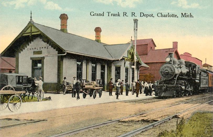
 Grand Trunk Depot, Charlotte, Michigan built in 1885.
Highways
Interstates
 I-69
I-69 I-69 Business Loop
Michigan Highways
 Michigan Highway M-50
 Michigan Highway M-79
Air
- In the northeast corner of the city is the Fitch H. Beach Airport.
- Scheduled passenger carrier flights are available at Capital Region International Airport, near the northeast corner of Eaton County.
Rail
- Charlotte was once serviced by the Grand Trunk Western Railroad& the Michigan Central Railroad. The original Michigan Central Railroad depot still stands at 430 N. Cochran Ave. and at various times has operated as a restaurant, ice cream parlor, and coffee shop.
Entertainment
A popular attraction is the Murder Mystery Dinner Train operated by the Old Road Railroad. While enjoying a leisurely trip through the countryside, a five course meal is served as theatrical entertainers perform a comical, and interactive murder mystery.
Theatres
The Eaton Theatre opened as a single screen in 1930 and is located downtown (235 S. Cochran). It was closed for a short time in 1960 and was later twinned by Beechler Theatres. Built during the Art Deco era it was totally modernized when it was twinned. It still has the large square marquee and the vertical sign, however the balcony area was transformed into a separate upstairs room to house a second screen.
The Charlotte Performing Arts Center (opened October 2004) is an 825-seat performance and instructional venue located at 378 State St. The auditorium is fully accessible with restrooms on all levels. The facility is fully air conditioned, and features an orchestra pit, "cushioned" stage floor, climate controlled storage, professional quality acoustical engineering, high-capacity electrical system for lights and sound with video projection capability on a large screen. The Charlotte Performing Arts Center hosts nationally-known events, as well as rental events and Charlotte Public School District events.
City Parks
The city of Charlotte has many wonderful parks. City Parks are open May 1 thru October 31. These include: Bennett Park (1225 S. Cochran), Dean Park (526 W. Stoddard), Gateway Park (N. Cochran and Packard), Lincoln Park (Lincoln St. and W. Shepherd), Oak Park (230 St. Clinton/Seminary St.), Snell Park (Upland and E. Shepherd), Southridge Park (312 W. Third), and U.S. Veterans Memorial Park (1501 S. Cochran).
Lincoln Park contains a Skate Park and Disc Golf Course. By the water tower nearby (at 619 W. Shepherd) there is a sled hill and ice skating rink.
Tennis Courts and Gobel Football field are located at 1149 S. Cochran.
A popular sled hill known locally as Kane's Hill (named after the Kane family who lived nearby and operated Kane's Heating Services) is located on Gale St. between Church St. and E. Lovett St.
Famous residents
- A. Whitney Brown – Comedian and writer, Saturday Night Live.
- Brock Gutierrez – Former NFL player.
- Eric Menk – Professional basketball player in Denmark and the Philippines.
- Harry T. Morey – Stage and film actor.
- Wayne Terwilliger – Major League Baseball player and coach.
- Rocco Moore- Former NFL player
References
- ^ a b "American FactFinder". United States Census Bureau. http://factfinder.census.gov. Retrieved 2008-01-31.
- ^ "US Board on Geographic Names". United States Geological Survey. 2007-10-25. http://geonames.usgs.gov. Retrieved 2008-01-31.
- ^ "Find a County". National Association of Counties. http://www.naco.org/Counties/Pages/FindACounty.aspx. Retrieved 2011-06-07.
External links
Municipalities and communities of Eaton County, Michigan County seat: Charlotte Cities Charlotte | Eaton Rapids | Grand Ledge‡ | Lansing‡ | Olivet | Potterville
Villages Bellevue | Dimondale | Mulliken | Sunfield | Vermontville
Charter
townshipsGeneral law
townshipsBellevue | Benton | Brookfield | Carmel | Chester | Eaton Rapids | Eaton | Hamlin | Kalamo | Roxand | Sunfield | Vermontville | Walton
Unincorporated
communityFootnotes ‡This populated place also has portions in an adjacent county or counties
Coordinates: 42°33′49″N 84°50′09″W / 42.56361°N 84.83583°W
Categories:- Populated places in Eaton County, Michigan
- Cities in Michigan
- County seats in Michigan
- Lansing – East Lansing metropolitan area
- Populated places established in 1863


Wikimedia Foundation. 2010.