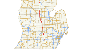
- U.S. Route 127 in Michigan
-
This article is about the section of highway in Michigan. For the entire length of highway, see US Highway 127.
US Highway 127
Route information Maintained by MDOT Length: 214.139 mi[3] (344.623 km) Existed: November 11, 1926[1][2] – present Major junctions South end:  US 127 near Prattville
 US 223 near Somerset
 US 12 near Somerset
 I-94 in Jackson

 I-96 / I-496 in Lansing
I-496 in Lansing
 I-69 near East Lansing
 US 10 near Clare
North end:  I-75 near Grayling
Location Counties: Lenawee, Hillsdale, Jackson, Ingham, Clinton, Gratiot, Isabella, Clare, Roscommon, Crawford Highway system United States Numbered Highways
List • Bannered • Divided • ReplacedMichigan State Trunkline Highway System
Interstate • US • State←  M-126
M-126M-129  →
→US Highway 127 (US 127) is a part of the United States Numbered Highway System that runs from Chattanooga, Tennessee, to the Lower Peninsula of the US state of Michigan. In Michigan, it is a state trunkline highway that runs for 214.12 miles (344.59 km), entering from Ohio south of Hudson and ending at a partial interchange with I-75 south of Grayling. Prior to 2002, US 127 ended at I-69 north of East Lansing, a total of approximately 83 miles (134 km).
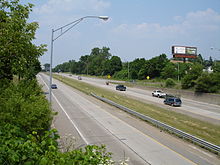
US 127 is the primary route connecting Lansing and Central Michigan to Northern Michigan and the Mackinac Bridge. From the south side of Jackson northerly, it is mostly a four-lane freeway, with posted speed limits of 70 miles per hour (113 km/h) for passenger cars, and 60 miles per hour (97 km/h) for trucks.
A notable exception is a 16-mile (26 km) stretch from north of St. Johns to just south of Ithaca, where access to the road is not limited and speeds are restricted to 65 miles per hour (105 km/h) for passenger cars, 55 miles per hour (89 km/h) for trucks.[4]
Contents
Route description
US 127 enters Michigan as a two-lane highway south of Hudson following the course (with minor deviations) of the Michigan Meridian used to survey Michigan in the early 19th century. That stretch is called Meridian Road north to Jackson. From the state line north, US 127 follows the Hillsdale–Lenawee county line north to Hudson and curves east into Addison. North of Addison is the intersection with US 223 at the northern/western terminus of US 223, and about a mile (1.6 km) farther north, US 12 in rural northwest Lenawee County, east of Somerset. US 127 continues northward to the Jackson area where it becomes a full freeway along the east side of Jackson. When US 127 and I-94 meet on the city's northeast side, they join together westward before US 127 splits off northward. The US 127 freeway continues northward through Leslie and Mason to the Lansing area.[5]
 US 127 through Lansing
In the Lansing area, US 127 follows the I-496/Ransom E. Olds Freeway around the city's east side north of I-96. Right near the Red Cedar River, just west of the Michigan State University campus, I-496 and US 127 separate as US 127 continues north and I-496 turns west. US 127 meets I-69 at the 1998–2002 terminus of the highway. From here north, US 127 follows the former US 27 north to Grayling.
The freeway ends just north of St. Johns. For a 16-mile (26 km) stretch north to just south of Ithaca, US 127 is a four-lane highway with cross-street traffic and driveway access to adjacent homes and businesses. While there are no immediate plans to convert this section to freeway, MDOT continues to purchase parcels for right-of-way to be used for future upgrades.[6]
MDOT has made several improvements to this stretch of roadway recently to improve safety and traffic flow. This includes the construction of an interchange at M-57 in 2000 in southern Gratiot County, replacing an accident-prone intersection.[7][8] In 2009, MDOT constructed median u-turn crossovers (also known as a "Michigan Left") at several intersections in northern Clinton County to remove cross-street traffic.[9] In April 2010, the MDOT raised speed limits for passenger cars on this non-freeway stretch to 65 miles per hour (105 km/h) from the previous 55 miles per hour (89 km/h).[4]
South of Ithaca, the highway becomes a freeway again for the remainder of its routing. US 127 crosses the Pine River in Alma and runs near the campus of Central Michigan University, crossing the Chippewa River in Mt. Pleasant. Mt. Pleasant is also home to the Saginaw Band of Chippewa Indians and their tribal reservation.[5]
There is a welcome center in the median of US 127/US 10 in Clare. US 127 continues north through the community of Harrison, county seat of Clare County. The freeway serves the resort areas of Houghton Lake and Higgins Lake in Roscommon County before ending 4 miles (6 km) south of Grayling at a partial interchange with I-75. Traffic along US 127 northbound has access to northbound I-75 and southbound traffic on I-75 can access US 127 southbound.[5]
History
US 127 debuted with the rest of the United States Numbered Highway System in 1926. This new designation replaced part or all of M-14, M-23, M-34 and M-80.[1][2][10] US 127 originally ran from the Toledo, Ohio area through Adrian to Jackson and Lansing. The southern end of US 127 was rerouted in 1930 from Somerset south to Hudson and on to Cincinnati, Ohio. The section of former US 127 between Somerset and Toledo became US 223.[11] The city of Mason was bypassed in 1954. The former route through town was designated BUS US 127 at the time.[12] The US 127 expressway was first started in 1957 with an extension south of Mason to Leslie.[13] A further extension to Jackson was opened in 1958.[14] By 1964 this expressway was converted to full freeway, complete with interchanges and the BUS US 127.[15] The US 127 freeway was extended north to the Lansing area by 1968. Near Lansing, it was routed along I-496 to the north side of Lansing and East Lansing to connect with US 27.[16] The last extension of US 127 for another 11 years was completed in 1973 when the freeway was completed north to DeWitt.[17] Two changes took place in the routing of US 127 in the 1980s as the I-69 freeway was completed. The northern Lansing bypass was completed in 1984[18] and I-69 was built through Clinton County in 1987.[19] These changes routed I-69 along a portion of US 127 near DeWitt and removed a TEMP I-69 routing from US 127 on the east side of Lansing. The opening of the St. Johns Bypass on August 31, 1998 shortened US 127 by almost 2 miles (3 km) while US 27 was routed along the I-69 freeway between exits 87 and 89 to connect with the new freeway northward.[20]
The Michigan Department of Transportation petitioned the American Association of State Highway and Transportation Officials (AASHTO) for approval to remove US 27 from Michigan in 1999. This would remove the 88-mile (142 km) concurrency of I-69 and US 27 south of the Lansing area. MDOT proposed that US 127 be extended north over the former US 27 to Grayling. AASHTO approved this change on April 16, 1999[21] nearly tripling the highway from 83 miles (134 km) to 214 miles (344 km). The highway markers were changed over in 2002, converting US 27 and the BUS US 27 routes to US 127 and BUS US 127 routes.[22] In 2011, an extra lane was added to the northbound lanes of US 127 between Grand River Avenue at mile marker 78 up to Lake Lansing Road, at exit 79.[citation needed]
Future
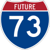
The original defined alignment of Interstate 73 (I-73) would have simply run along I-75 to Detroit.[23] However, the definition was amended in 1995 to have a branch along the US 223 corridor to south of Jackson and the US 127 corridor (formerly US 27 north of Lansing until 2002) north to I-75 near Grayling. From Grayling it would simply use I-75 to Sault Ste. Marie.[24] Except south of Jackson, where it is a two-lane road and a section of road north of Lansing where the freeway reverts to a divided highway, this is mostly a rural four-lane freeway.[5] MDOT abandoned further study of I-73 after June 12, 2001, diverting remaining funding to safety improvement projects along the corridor.[25] MDOT included using the US 223 corridor as one of its three options to build I-73 in 2000. The others included using the US 127 corridor all the way into Ohio with a connection to the Ohio Turnpike or using US 127 south and a new freeway connection to US 223 at Adrian.[26] MDOT abandoned further study of I-73 after June 12, 2001, diverting remaining funding to safety improvement projects along the corridor.[27] The department stated there was a "lack of need" for sections of the proposed freeway, and the project website was closed down in 2002.[28] According to press reports in 2011, a group advocating on behalf of the freeway is working to revive the I-73 project in Michigan. According to an MDOT spokesman, "to my knowledge, we’re not taking that issue up again."[29] The Lenawee County Road Commission is not interested in the freeway, and according to the president of the Adrian Area Chamber of Commerce, "there seems to be little chance of having an I-73 link between Toledo and Jackson built in the foreseeable future."[29]
Exit list
- US 127 was updated with exit numbers on the freeway sections as of 2008.
County Location Mile Exit Destinations Notes Lenawee Medina Township 0.000 US 127 southOhio state line Hudson  M-34 – Hudson
Woodstock Township US 223 south – AdrianSouthern end of unsigned US 223 concurrency US 12 – SomersetNorthern end of unsigned US 223 concurrency Hillsdale No major junctions Jackson Summit Township 34 


 BUS US 127 / M-50 – Jackson
Freeway begins Leoni Township 36 South Street 38 Page Avenue 39  BL I-94 (Michigan Avenue)
40 I-94 east – Ann ArborEastern end of I-94/US 127 concurrency; freeway uses I-94 exit numbers, signed as exit 142 southbound Blackman Charter Township 141 Elm Avenue 139  M-106 (Cooper Street) – Stockbridge
138 I-94 west – Battle Creek
BUS US 127 / M-50 – Jackson, NapoleonWestern end of I-94 concurrency; south end of M-50 concurrency; signed as 43A (east) and 43B (west) southbound 44 Springport Road, Shirley Drive Northbound access at Shirley Drive 45 Parnall Road Southbound interchange provides access to westbound M-50 via Clinton Way 46 M-50 west – Eaton Rapids, CharlotteNorthbound exit and southbound entrance; north end of M-50 concurrency Rives Township 51 Berry Road – Rives Junction Ingham Leslie 56 Bellevue Road – Leslie Vevay Township 61 Barnes Road 64 Kipp Road – Mason Mason 66  M-36 (Cedar Street) – Mason
Alaiedon Township 70 Holt Road – Holt Delhi Charter Township 73 I-96 – Grand Rapids, Detroit
I-496Numbered as 73 A&B; southern end of I-496 concurrency, freeway uses I-496 exit numbers Lansing 11 Jolly Road 9 Trowbridge Road Marked as exit 75 on southbound US 127 76 Kalamazoo Street, Michigan Avenue Northbound exit and southbound entrance 77 I-496 - Downtown LansingNorthern end of I-496 concurrency; exit 8 on I-496 78 
 BL I-69 / M-43 (Grand River Avenue, Saginaw Street) – Grand Ledge, Okemos
East Lansing 79 Lake Lansing Road Clinton DeWitt Charter Township 82 I-69 – Flint, MarshallNumbered as 82 A&B Olive Township 86 Round Lake Road – DeWitt 91
BUS US 127 (Price Road) – St. JohnsBingham Township 96  M-21 – Ionia, Owosso
99
BUS US 127 (OLD US 27) – St. JohnsFreeway ends Gratiot Washington Township 109  M-57 (Cleveland Avenue) – Greenville, Chesaning
Partial Cloverleaf Interchange Ithaca 117
BUS US 127 (Center Street, Washington Road) – IthacaFreeway begins 119
BUS US 127 (Polk Road) – IthacaEmerson Township 123
BUS US 127 north (Lincoln Road) – AlmaBusiness loop through Alma; northbound exit and southbound entrance 124
BUS US 127 (State Road) – St. LouisBusiness loop through St. Louis Pine River Township 127
 BUS US 127 south / M-46 – St. Louis
BUS US 127 – AlmaExit 127A is northern terminus of BUS US 127 for St. Louis; exit 127B is northern terminus of BUS US 127 for Alma; southbound exit and northbound entrance Isabella Shepherd 135 Wright Avenue/Blanchard Road – Shepherd Mt. Pleasant 139
BUS US 127 north (Mission Street) – Mt. PleasantNorthbound exit and southbound entrance 143  M-20 (Pickard Street) – Big Rapids, Midland
144
BUS US 127 south (Mission Street) – Mt. PleasantSouthbound exit and northbound entrance Rosebush 149 Rosebush Road – Rosebush Clare 156
BUS US 127 north – ClareNorthbound entrance and southbound exit; access to eastbound US 10 by way of BUS US 10 Clare 158 US 10 east – MidlandSouth end of US 127/US 10 concurrency
Southbound exit and northbound entrance
Concurrency uses US 127 exit numbers160
BUS US 127 south (Clare Avenue) / BUS US 10 east – Clare162  US 10 west to M-115 – Reed City, Cadillac
Northern end ofUS 10 concurrency Hayes Township 168 Mannsiding Road – Lake George Harrison 170
 BUS US 127 / M-61 (Clare Avenue) – Harrison
Hayes Township 176
BUS US 127 (Clare Avenue) – HarrisonRoscommon Roscommon Township 189 Snow Bowl Road Houghton Lake 194  M-55 (Lake City Road) – Lake City, West Branch
Signed as exits 194A (east) and 194B (west) southbound Lyon Township 201 West Higgins Lake Road Crawford Beaver Creek Township 206 Military Road, North Higgins Lake Road I-75 – Mackinac Bridge, SaginawExit 249 on I-75; northbound exit and southbound entrance 1.000 mi = 1.609 km; 1.000 km = 0.621 mi
Concurrency terminus • Closed/Former • Incomplete access • UnopenedReferences
- ^ a b Weingroff, Richard F. (January 9, 2009). "From Names to Numbers: The Origins of the US Numbered Highway System". Federal Highway Administration. http://wwwcf.fhwa.dot.gov/infrastructure/numbers.cfm. Retrieved April 21, 2009.
- ^ a b Bureau of Public Roads (1926) (PDF). United States System of Highways (Map). http://www.okladot.state.ok.us/hqdiv/p-r-div/maps/misc-maps/1926us.pdf. Retrieved May 10, 2008.
- ^ "MDOT Physical Reference Finder Application". Michigan Department of Transportation. 2009. http://www.mcgi.state.mi.us/prfinder/. Retrieved November 18, 2010.
- ^ a b "US 127 Speed Limit to Increase Beginning in Early April" (Press release). Michigan Department of Transportation. April 2, 2010. http://www.michigan.gov/mdot/0,1607,7-151-9620_11057-234739--,00.html. Retrieved April 10, 2010.
- ^ a b c d Michigan Department of Transportation (2008). Official 2008 Department of Transportation Map (Map). 1 in:15 mi/1 cm:9 km. Section H10-N11.
- ^ Rook, Christine (July 12, 2009). "Finishing US 127 Still Has Support". Lansing State Journal. http://www.lansingstatejournal.com/article/20090712/NEWS01/907120438. Retrieved July 13, 2009.[dead link]
- ^ Michigan Department of Transportation (1999). Michigan Department of Transportation Map (Map). 1 in:14.5 mi/1 cm:9 km. Section K11.
- ^ Michigan Department of Transportation (2000). Michigan Department of Transportation Map (Map). 1 in:14.5 mi/1 cm:9 km. Section K11.
- ^ "MDOT Begins Construction on US 127 North of St. Johns in Clinton County" (Press release). Michigan Department of Transportation. April 29, 2009. http://www.michigan.gov/mdot/0,1607,7-151-9620_11057-213793--,00.html. Retrieved April 10, 2010.
- ^ Michigan State Highway Department (July 1, 1919). State of Michigan (Map). Cartography by MSHD. http://maps.lib.msu.edu/miroadmaps/mirm5.htm. Retrieved May 10, 2008.
- ^ Automobile Legal Association (1930). "Route Log of State Highway Systems". Automobile Green Book (1930–31 edition ed.). Boston: Scarborough Motor Guide Co.. pp. 45+.
- ^ Michigan State Highway Department (April 1, 1954). State of Michigan (Map). Cartography by MSHD.
- ^ Michigan State Highway Department (April 1, 1957). State of Michigan (Map). Cartography by MSHD.
- ^ Michigan State Highway Department (July 1, 1958). State of Michigan (Map). Cartography by MSHD.
- ^ Michigan State Highway Department (1964). State of Michigan (Map). Cartography by MSHD.
- ^ Michigan Department of State Highways (1968). Official Highway Map (Map). Cartography by MDSH.
- ^ Michigan Department of State Highways (1973). Official Highway Map (Map). Cartography by MDSH.
- ^ Michigan Department of Transportation (1984). Official Department of Transportation Map (Map).
- ^ Michigan Department of Transportation (1987). Official Department of Transportation Map (Map).
- ^ "Governor Engler Opens US 27 Freeway" (Press release). Michigan Department of Transportation. August 31, 1998. http://www.michigan.gov/mdot/0,1607,7-151-9620_11057-94897--,00.html. Retrieved May 24, 2008.
- ^ "Report of the Special Committee on Route Numbering to the Standing Committee on Highways" (PDF). American Association of State Highway and Transportation Officials. April 17, 1999. http://cms.transportation.org/sites/route/docs/1999-USRN_Cmte.pdf. Retrieved May 24, 2008.
- ^ Michigan Department of Transportation (2002). Official 2002–03 Department of Transportation Map (Map).
- ^ "Intermodal Surface Transportation Efficiency Act of 1991". U.S. Congress. December 18, 1991. http://ntl.bts.gov/DOCS/istea.html. Retrieved September 28, 2010. "§1105(c)(5) I-73/74 North-South Corridor from Charleston, South Carolina, through Winston-Salem, North Carolina, to Portsmouth, Ohio, to Cincinnati, Ohio, and Detroit, Michigan."
- ^ "The National Highway System Designation Act of 1995". U.S. Congress. November 28, 1995. http://www.fhwa.dot.gov/legsregs/title3.html#332. Retrieved September 28, 2010. "§1105(c)(5) I-73/74 North-South Corridor from Charleston, South Carolina, through Winston-Salem, North Carolina, to Portsmouth, Ohio, to Cincinnati, Ohio, to termini at Detroit, Michigan and Sault Ste. Marie, Michigan. The Sault Ste. Marie terminus shall be reached via a corridor connecting Adrian, Jackson, Lansing, Mount Pleasant, and Grayling, Michigan."
- ^ "MDOT Postpones Further Studies Along I-73 Corridor" (Press release). Michigan Department of Transportation. June 12, 2001. Archived from the original on December 31, 2004. http://web.archive.org/web/20050228055502/www.michigan.gov/mdot/0,1607,7-151-9620_11057-75166--M_2001_6,00.html. Retrieved September 28, 2010.
- ^ "Michigan Settles on 3 Options for I-73: State Still May Decide not to Build Highway". Toledo Blade: p. B2. December 14, 2000. http://news.google.com/newspapers?id=38wpAAAAIBAJ&sjid=wQMEAAAAIBAJ&pg=6389,4543775&dq=us+223+michigan+%7C+toledo+%7C+ohio&hl=en. Retrieved December 19, 2010.
- ^ "MDOT Postpones Further Studies Along I-73 Corridor" (Press release). Michigan Department of Transportation. June 12, 2001. Archived from the original on December 31, 2004. http://web.archive.org/web/20050228055502/www.michigan.gov/mdot/0,1607,7-151-9620_11057-75166--M_2001_6,00.html. Retrieved September 28, 2010.
- ^ "South Takes the Lead: I-73 Will Push from South to North" (PDF). Marion Star & Mullins Enterprise (Marion County, SC: Media General Carolina). August 22, 2007. http://www.i73.com/pdf/South%20takes%20the%20lead%20I-73%2008.24.07.pdf. Retrieved January 4, 2011.
- ^ a b Pelham, Dennis (July 16, 2011). "Group Seeks to Revive I-73 Interest in Michigan". The Daily Telegram (Adrian, MI). http://www.lenconnect.com/news/x121480165/Group-seeks-to-revive-I-73-interest-in-Michigan. Retrieved September 6, 2011.
US Highway 127Previous state:
OhioMichigan Next state:
TerminusNorthern Michigan Topics Major Highways Central cities Satellite cities Region Outlying regions Counties See also: MichiganCategories:
- U.S. Highways in Michigan
- U.S. Route 127
- Freeways and expressways in Michigan
- Central Michigan
- Northern Michigan
- Transportation in Lansing, Michigan


Wikimedia Foundation. 2010.