- Cheboygan County, Michigan
-
Cheboygan County, Michigan 
Seal
Location in the state of Michigan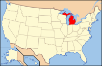
Michigan's location in the U.S.Founded 1840 Seat Cheboygan Largest city Cheboygan Area
- Total
- Land
- Water
885.23 sq mi (2,293 km²)
715.60 sq mi (1,853 km²)
169.63 sq mi (439 km²), 19.16%Population
- (2000)
- Density
26,448
36/sq mi (14/km²)Website www.cheboygancounty.net Cheboygan County is a county in the U.S. state of Michigan. As of the 2000 census, the population was 26,448. The county seat is Cheboygan[1].
The name of the county shares the same origin as that of the Cheboygan River, although the precise meaning is no longer known. It may have come from an Ojibwe word zhaabonigan meaning "sewing needle". Alternatively, the origin may have been "Chabwegan," meaning "a place of ore".[2] See List of Michigan county name etymologies.
The county boundaries were set off in 1840 and county government organized in 1853.[3]
Contents
Geography
- According to the 2000 census, the county has a total area of 885.23 square miles (2,292.7 km2), of which 715.60 square miles (1,853.4 km2) (or 80.84%) is land and 169.63 square miles (439.3 km2) (or 19.16%) is water.[4]
- The county is considered to be part of Northern Michigan.
Adjacent counties
- Mackinac County - north
- Presque Isle County - east
- Montmorency County - southeast
- Otsego County - south
- Charlevoix County - southwest
- Emmet County - west

Straits of Mackinac Mackinac County Lake Huron Emmet County 
Presque Isle County  Cheboygan County, Michigan

Charlevoix County Otsego County Montmorency County Transportation
Airports
Private
Cheboygan County Airport (Cheboygan)
Commercial Airline
There are no commercial airline airports in Cheboygan County but the nearest ones are Alpena County Regional Airport, Chippewa County International Airport (Sault Ste. Marie, MI), and Cherry Capital Airport (Traverse City). Delta Air Lines schedules flights daily out of the Pellston Regional Airport.
Interstates
US Highways
Michigan State Trunklines
Cheboygan County Intercounty Highways
 C-58
C-58 C-64
C-64 C-66
C-66 F-05
F-05
Demographics
As of the census[5] of 2000, there were 26,448 people, 10,835 households, and 7,573 families residing in the county. The population density was 37 people per square mile (14/km²). There were 16,583 housing units at an average density of 23 per square mile (9/km²). The racial makeup of the county was 94.80% White, 0.25% Black or African American, 2.55% Native American, 0.20% Asian, 0.02% Pacific Islander, 0.15% from other races, and 2.05% from two or more races. 0.76% of the population were Hispanic or Latino of any race. 21.4% were of German, 10.4% English, 10.0% French, 9.5% Polish, 9.2% American and 8.9% Irish ancestry according to Census 2000. 97.7% spoke English as their first language.
There were 10,835 households out of which 28.60% had children under the age of 18 living with them, 58.00% were married couples living together, 8.60% had a female householder with no husband present, and 30.10% were non-families. 25.80% of all households were made up of individuals and 11.80% had someone living alone who was 65 years of age or older. The average household size was 2.41 and the average family size was 2.87.
In the county the population was spread out with 23.70% under the age of 18, 6.20% from 18 to 24, 25.80% from 25 to 44, 26.30% from 45 to 64, and 17.90% who were 65 years of age or older. The median age was 41 years. For every 100 females there were 98.30 males. For every 100 females age 18 and over, there were 96.50 males.
The median income for a household in the county was $33,417, and the median income for a family was $38,390. Males had a median income of $30,054 versus $20,682 for females. The per capita income for the county was $18,088. About 8.70% of families and 12.20% of the population were below the poverty line, including 17.90% of those under age 18 and 7.10% of those age 65 or over.
Government
The county government operates the jail, maintains rural roads, operates the major local courts, keeps files of deeds and mortgages, maintains vital records, administers public health regulations, and participates with the state in the provision of welfare and other social services. The county board of commissioners controls the budget but has only limited authority to make laws or ordinances. In Michigan, most local government functions — police and fire, building and zoning, tax assessment, street maintenance, etc. — are the responsibility of individual cities and townships.
Cheboygan County elected officials
- Prosecuting Attorney: Daryl Vizina
- Sheriff: Dale Clarmont
- County Clerk/Register of Deeds: Mary Ellen Tryban
- County Treasurer: Linda Cronan
- Drain Commissioner: Dennis Lennox
- County Surveyor: James H. Granger
(information as of November 2008)
Cities, villages, and townships
Unincorporated
- Afton
- Aloha
- Alverno
- Burt Lake
- Elmhurst
- Indian River
- Mullett Lake
- Riggsville
- Topinabee
- Tower
Townships
Historical Note: Cheboygan County had another township called Maple Grove Township, and it became part of Forest Township in 1942.
Historical markers
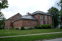 Jail and Sheriff's Residence, now the Cheboygan County Historical Museum Complex
There are eight recognized Michigan historical markers in the county:[6]
- Forty Mile Point Lighthouse / Graveyard of Ships
- Inland Waterway
- Jacob J. Post House
- Jail and Sheriff's Residence
- Newton-Allaire House
- Old Cheboygan County Courthouse
- St. Bernard Catholic Church
- St. Mary's Church
See also
- National Register of Historic Places listings in Cheboygan County, Michigan
- USS Cheboygan County (LST-533)
Notes
- ^ "Find a County". National Association of Counties. http://www.naco.org/Counties/Pages/FindACounty.aspx. Retrieved 2011-06-07.
- ^ Michigan County names per the Michigan government.
- ^ Clarke Historical Library, Central Michigan University, Bibliography on Cheboygan County.
- ^ "Census 2000 U.S. Gazetteer Files: Counties". United States Census. http://www.census.gov/tiger/tms/gazetteer/county2k.txt. Retrieved 2011-02-13.
- ^ "American FactFinder". United States Census Bureau. http://factfinder.census.gov. Retrieved 2008-01-31.
- ^ Michigan Historical Markers
External links
- Cheboygan County official site
- Clarke Historical Library, Central Michigan University, Bibliography on Cheboygan County.
- Cheboygan County's Historic Bridges
- Enchanted forest, Northern Michigan source for information, calendars, etc.
- YourCheboygan.org, Open forum for community feedback
Municipalities and communities of Cheboygan County, Michigan City 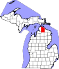
Villages Townships Unincorporated
communitiesAfton | Burt Lake | Elmhurst | Indian River | Mullett Lake | Topinabee | Tower
Footnotes ‡This populated place also has portions in an adjacent county or counties
Northern Michigan Topics Major Highways Central cities Satellite cities Region Outlying regions Counties See also: MichiganCategories:
- Michigan counties
- Cheboygan County, Michigan


Wikimedia Foundation. 2010.